
Southern Coastal Islands of Puerto Rico
Caja de Muertos and the Cays of the Caribbean Coast
Along Puerto Rico's southern Caribbean coastline lies a collection of small islands, mangrove cays, rocky formations, and shallow marine habitats that reflect the region's distinctive coastal geography.
From the waters near Guayama and Salinas to the offshore islands of Ponce and Guayanilla, these coastal formations are shaped by a warmer, generally drier climate and a complex network of bays, reefs, and mangrove ecosystems.
The best-known destination is Caja de Muertos, an uninhabited island south of Ponce, recognized for its historic lighthouse, dry coastal vegetation, beaches, and protected natural habitats.
Other southern cays are much smaller, consisting of mangrove-covered islands, sandy formations, and rocky outcrops that provide important habitats for marine life and coastal wildlife.
Together, these islands contribute to Puerto Rico's biodiversity, maritime history, and Caribbean coastal heritage.
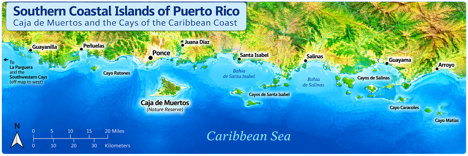
Southern Coastal Islands at a Glance
Puerto Rico's southern coastal islands include small offshore islands, mangrove cays, and rocky formations scattered along the Caribbean-facing coastline.
| Feature | Description |
|---|---|
| Location | Southern coast of Puerto Rico |
| Surrounding waters | Caribbean Sea |
| Notable island | Caja de Muertos |
| Principal coastal areas | Guayama, Salinas, Santa Isabel, Ponce, and Guayanilla |
| Common formations | Small islands, mangrove cays, rocky islets, and coastal reefs |
| Natural features | Dry coastal forests, mangroves, seagrass beds, and coral reefs |
| Protected areas | Caja de Muertos Nature Reserve and other coastal conservation areas |
| Accessibility | Varies by island; some require boats or have restricted access |
| Ecological importance | Marine biodiversity, seabird habitats, coastal protection |
Where Are Puerto Rico's Southern Coastal Islands?
Puerto Rico's southern coastal islands are distributed along the Caribbean-facing shoreline, particularly near the municipalities of Guayama, Salinas, Santa Isabel, Ponce, and Guayanilla.
Unlike La Cordillera in northeastern Puerto Rico, these formations do not form a single continuous island chain. Instead, they are scattered across shallow bays, coastal lagoons, reef systems, and offshore waters.
Caja de Muertos lies approximately 5 miles (8 kilometers) south of Ponce and is one of the region's most recognizable offshore islands.
Other southern cays are located much closer to the mainland, particularly in sheltered coastal environments where mangroves and seagrass beds thrive.
Notable Southern Coastal Islands and Cays
Puerto Rico's southern coastline includes a variety of offshore islands, mangrove cays, and rocky formations. These islands differ in size, geography, ecological importance, and accessibility.
The most recognizable is Caja de Muertos, located south of Ponce. Other smaller cays are associated with the shallow bays, mangrove forests, and marine ecosystems of southern Puerto Rico.
Caja de Muertos — Ponce
Isla Caja de Muertos is one of Puerto Rico's most distinctive offshore islands. Located approximately 5 miles (8 kilometers) south of Ponce, the island is known for its rugged landscape, dry coastal vegetation, sandy beaches, and historic lighthouse.
The island's name translates to Coffin Island, possibly referring to its elongated shape, although several local legends offer alternative explanations.
Caja de Muertos forms part of the Reserva Natural Isla Caja de Muertos, which protects important terrestrial and marine habitats.
The island's surrounding waters support coral communities, reef fish, and other marine organisms, while its coastal habitats provide refuge for seabirds and other wildlife.
Its historic lighthouse, completed in the nineteenth century, reflects the island's importance as a navigational landmark along Puerto Rico's southern coast.
Cayo Ratones — Ponce
Cayo Ratones is a small coastal cay associated with the waters near Ponce.
Like other small offshore formations along the southern coast, it forms part of the region's coastal geography and marine environment.
The name Ratones is used for more than one coastal feature in Puerto Rico, making geographic identification important when documenting individual cays.
Mangrove Cays of Salinas
The coastal waters of Salinas contain shallow bays, mangrove habitats, and small offshore formations associated with the Caribbean coastal environment.
Mangrove-covered cays provide shelter for juvenile fish, crustaceans, and other marine organisms. Their root systems also help stabilize sediments and protect nearby shorelines.
These coastal habitats contribute to the ecological importance of the Salinas region.
Coastal Cays of Santa Isabel
The southern coastline of Santa Isabel includes shallow marine environments, coastal wetlands, and small offshore formations.
These habitats support marine biodiversity and provide feeding and resting areas for coastal birds.
The surrounding seagrass beds and shallow waters also contribute to the ecological productivity of the region.
Guayanilla's Coastal Formations
The coastal waters near Guayanilla include sheltered bays, rocky shorelines, and small offshore features.
These formations contribute to the geographic diversity of Puerto Rico's southern Caribbean coastline and provide habitat for marine organisms and coastal wildlife.
Islands and Cays of Puerto Rico's Southern Coast
Puerto Rico's southern coastal islands are distributed among several municipalities along the Caribbean Sea. They range from larger offshore islands to small mangrove-covered cays and rocky formations.
The following table highlights selected islands and coastal areas associated with southern Puerto Rico.
| Municipality | Island or Coastal Area | Notable Characteristics |
|---|---|---|
| Ponce | Caja de Muertos | Protected offshore island known for its historic lighthouse, dry coastal landscapes, beaches, and marine ecosystems. |
| Ponce | Cayo Ratones | Small coastal cay; precise geographic identification should be verified against the municipality directory. |
| Salinas | Mangrove cays and coastal formations | Shallow bays, mangrove habitats, seagrass beds, and coastal marine ecosystems. |
| Santa Isabel | Small coastal cays and offshore formations | Shallow coastal waters, marine habitats, and coastal wetlands. |
| Guayama | Coastal islands and cays | Caribbean coastal environments associated with mangroves, reefs, and shallow bays. |
| Guayanilla | Coastal rocks and offshore formations | Sheltered bays, rocky coastal features, and marine habitats. |
Caja de Muertos Nature Reserve
Reserva Natural Isla Caja de Muertos
The Reserva Natural Isla Caja de Muertos protects one of Puerto Rico's most recognizable offshore islands and its surrounding natural environments.
Located south of Ponce, the reserve includes dry coastal vegetation, sandy beaches, rocky shorelines, and important marine habitats.
The island's relatively isolated location has helped preserve natural landscapes that differ from those of Puerto Rico's more developed coastal areas.
Its surrounding waters support coral communities, seagrass habitats, reef fish, and other marine organisms.
Why the Reserve Matters
Coastal Biodiversity: The island provides habitats for seabirds, reptiles, and other wildlife adapted to dry coastal environments.
Marine Conservation: Coral reefs, seagrass beds, and surrounding coastal waters support diverse marine ecosystems.
Geological Heritage: The island's rugged terrain and rocky coastline reflect the geological history of southern Puerto Rico.
Maritime History: The historic Caja de Muertos Lighthouse reflects the island's role in navigation and Puerto Rico's maritime heritage.
The Caja de Muertos Lighthouse
The Faro de Isla Caja de Muertos was constructed during the Spanish colonial period and began operating in 1887.
Its elevated position helped guide vessels navigating the waters along Puerto Rico's southern coast.
Today, the lighthouse remains an important historical landmark associated with the island.
Did You Know?
Caja de Muertos means Coffin Island in Spanish. One explanation connects the name to the island's elongated shape, while local traditions preserve other stories about its origins.
Mangrove Cays and Southern Coastal Ecosystems
Puerto Rico's southern coastline contains extensive shallow marine environments that support mangroves, seagrass beds, coral reefs, and coastal wetlands.
Unlike the rocky offshore formations found along parts of the northern Atlantic coast, many southern cays are low-lying and associated with sheltered bays and shallow coastal waters.
These ecosystems contribute to marine biodiversity, coastal protection, and the ecological health of southern Puerto Rico.
Mangrove Islands
Mangrove cays are small islands or coastal formations dominated by salt-tolerant trees and shrubs.
Their complex root systems help stabilize sediments, reduce shoreline erosion, and provide shelter for juvenile fish, crabs, and other marine organisms.
Mangroves also serve as important feeding and resting habitats for coastal birds.
Seagrass Beds
Seagrass meadows grow in suitable shallow coastal waters and provide important feeding grounds and shelter for marine wildlife.
These underwater habitats help stabilize sediments, improve water clarity, and support productive coastal food webs.
Seagrass beds also provide habitat for juvenile fish and feeding areas for certain sea turtles and other marine species.
Coral Reefs
Coral reefs occur in suitable marine environments along Puerto Rico's southern coast.
They support diverse communities of fish, invertebrates, and other marine organisms.
Reefs can also help reduce wave energy, contributing to the protection of nearby coastal environments.
Coastal Wildlife
Southern coastal islands and cays provide habitat for seabirds, fish, crustaceans, reptiles, and other wildlife.
Some protected coastal areas also support sea turtles and other species of conservation concern.
Environmental Challenges
Southern coastal ecosystems face pressures from coastal development, pollution, habitat loss, and changing marine conditions.
Rising sea temperatures, coral bleaching, and stronger storm impacts may also affect sensitive marine environments.
Protecting mangroves, reefs, and seagrass beds is essential for preserving Puerto Rico's coastal biodiversity.
Visiting Puerto Rico's Southern Coastal Islands
Puerto Rico's southern coastal islands offer opportunities to experience Caribbean scenery, dry coastal landscapes, and diverse marine environments.
However, accessibility varies considerably between destinations. Some islands require boat transportation, while others may have restricted access because of conservation regulations or limited visitor infrastructure.
Getting There
Caja de Muertos is reached by boat from the Ponce area when authorized transportation and visitor access are available.
Other southern cays may require private boats or guided excursions, depending on their location and current access restrictions.
Unlike Vieques and Culebra, these smaller offshore islands generally do not have regular public ferry service.
What to Expect
Depending on the destination and applicable regulations, visitors may enjoy boating, coastal sightseeing, nature observation, hiking, and snorkeling.
Caja de Muertos is particularly notable for its historic lighthouse, dry coastal vegetation, and protected natural landscapes.
Many smaller cays have limited or nonexistent visitor facilities.
Responsible Island Travel
Southern coastal ecosystems are sensitive to human activity, particularly mangrove habitats, coral reefs, and seagrass beds.
- Respect protected areas and posted access restrictions.
- Avoid disturbing nesting birds and other wildlife.
- Do not damage mangrove roots or coastal vegetation.
- Never anchor on coral reefs or seagrass beds.
- Do not remove shells, coral, plants, or wildlife.
- Carry out all trash and personal belongings.
- Check weather and marine conditions before traveling.
Local Tip
Confirm access before planning your trip. Boat transportation to Caja de Muertos may not operate regularly, and access can change because of conservation requirements, weather conditions, or infrastructure limitations.
Before traveling to Ponce specifically to visit the island, confirm current access arrangements and transportation availability.
Southern Coastal Islands vs. Northern and Eastern Islands
Puerto Rico's southern coastal islands differ from the rocky formations of the northern Atlantic coast and the island-and-reef system near Fajardo.
The Southern Coastal Islands include Caja de Muertos and smaller cays associated with Caribbean coastal bays, mangroves, and marine habitats.
The Northern Coastal Islands are scattered along the Atlantic-facing shoreline, while the Eastern Coastal Islands are concentrated around La Cordillera near Fajardo.
Comparing Puerto Rico's Coastal Island Groups
| Feature | Southern Coastal Islands | Northern Coastal Islands | Eastern Coastal Islands |
|---|---|---|---|
| Location | Caribbean-facing southern coast | Atlantic-facing northern coast | Northeastern coast near Fajardo |
| Notable islands | Caja de Muertos and southern cays | Scattered rocky islets and coastal formations | Icacos, Palomino, Palominito |
| Geographic arrangement | Scattered offshore islands and coastal cays | Isolated coastal rocks and islets | La Cordillera island-and-reef system |
| Typical formations | Mangrove cays, rocky islands, coral reefs | Rocky islets, limestone coastal features | Sandy cays, small islands, coral reefs |
| Coastal environment | Generally drier landscapes and sheltered bays | Atlantic-exposed coastline | Offshore island-and-reef environments |
| Natural habitats | Mangroves, seagrass beds, reefs, dry coastal vegetation | Rocky shores, reefs, seabird habitats | Coral reefs, seagrass beds, coastal vegetation |
| Accessibility | Varies; some destinations require boats or have restrictions | Many formations best viewed from shore | Several destinations accessible by boat excursions |
| Main interests | Nature, maritime history, marine conservation | Geology, coastal scenery, history | Snorkeling, boating, marine recreation |
Caja de Muertos and the smaller southern cays are associated with Puerto Rico's Caribbean-facing coastline, while northern coastal formations face the Atlantic Ocean.
The eastern coastal islands form a separate island-and-reef system near Fajardo. Together, these regions illustrate the diversity of Puerto Rico's offshore geography.
Frequently Asked Questions
Find answers to common questions about Caja de Muertos, Puerto Rico's southern coastal cays, their natural environments, and visitor accessibility.
What are Puerto Rico's southern coastal islands?
Puerto Rico's southern coastal islands include small offshore islands, mangrove cays, and rocky formations located along the island's Caribbean-facing southern coastline. Caja de Muertos is one of the region's most recognizable islands.
Where is Caja de Muertos located?
Caja de Muertos is located approximately 5 miles (8 kilometers) south of Ponce, Puerto Rico, in the Caribbean Sea.
Can you visit Caja de Muertos?
Visits may be possible when authorized transportation and public access are available. Travelers should confirm current access regulations and boat service before planning a trip.
Is Caja de Muertos inhabited?
No. Caja de Muertos has no permanent civilian population. It is a protected natural area known for its coastal landscapes, wildlife, and historic lighthouse.
Why is Caja de Muertos important?
Caja de Muertos is significant for its protected natural habitats, historic lighthouse, geological features, and surrounding marine ecosystems. The island also contributes to Puerto Rico's maritime and environmental heritage.
What are mangrove cays?
Mangrove cays are small islands dominated by salt-tolerant trees and shrubs. Their root systems help stabilize coastal sediments, reduce erosion, and provide important habitats for fish, crustaceans, and coastal wildlife.
Are Puerto Rico's southern coastal islands protected?
Some southern coastal islands and surrounding marine habitats are included in natural reserves or other conservation areas. Protection and access regulations vary by location.
How are the southern coastal islands different from the northern coastal islands?
Southern coastal islands lie along Puerto Rico's Caribbean-facing shoreline and often include mangrove habitats, shallow bays, and coral reefs. Northern coastal formations face the Atlantic Ocean and frequently include rocky islets, limestone cliffs, and areas exposed to stronger ocean swells.
Continue Exploring Puerto Rico
North Coast
Explore Puerto Rico's North Coast, home to Atlantic beaches, dramatic karst landscapes, caves, and communities stretching west from San Juan.
East Coast
Discover Puerto Rico's East Coast, where El Yunque, Luquillo's beaches, Fajardo, and coastal nature reserves create endless opportunities for outdoor adventure.
Central Mountains
Journey into Puerto Rico's Central Mountains for coffee country, cooler temperatures, scenic roads, forests, and traditional mountain towns.
Metro Area
Experience Puerto Rico's Metro Area, home to San Juan, historic Old San Juan, beaches, museums, restaurants, nightlife, shopping, and the island's largest urban center.
West Coast
Head to Puerto Rico's West Coast for legendary surfing, beautiful sunsets, beaches, and lively coastal towns such as Rincón and Mayagüez.
South Coast
Explore Puerto Rico's South Coast for historic Ponce, Caribbean beaches, dry forests, coastal communities, and a slower pace.
Did You Know?
The poverty rate in Puerto Rico decreased by 1.3 percentage points, from 44.4% in 2017 to 43.1% in 2018.
Get Our Newsletter
Discover new places, local flavors, upcoming events, cultural stories, and some of our favorite finds from around the island.Read the Latest ¡La Isla! Newsletter
Follow Along


