
Eastern Coastal Islands of Puerto Rico
Icacos, Palomino, Palominito, and the Cays of La Cordillera
Just off Puerto Rico's northeastern coast lies a chain of small islands, cays, and coral reefs known as La Cordillera. Stretching eastward from the waters near Fajardo, these offshore formations are among the most distinctive features of Puerto Rico's coastal geography.
The region includes popular destinations such as Icacos, Palomino, and Palominito, along with smaller cays and rocky formations that support important marine and coastal ecosystems.
Surrounded by turquoise waters, coral reefs, and seagrass beds, these islands are known for their natural beauty, snorkeling opportunities, and ecological significance. While some welcome visitors arriving by boat, others are protected, privately owned, or unsuitable for recreational access.
Together, they form an important part of Puerto Rico's eastern archipelago, distinct from the Spanish Virgin Islands of Vieques and Culebra.
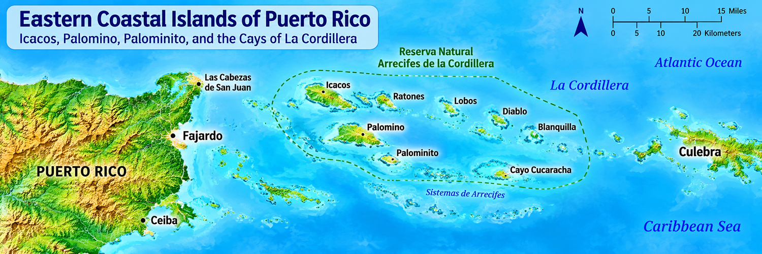
Eastern Coastal Islands at a Glance
Puerto Rico's eastern coastal islands form part of La Cordillera, a chain of small islands, cays, and coral reefs located off the northeastern coast near Fajardo.
| Feature | Description |
|---|---|
| Location | Northeastern coast of Puerto Rico |
| Principal municipality | Fajardo |
| Geographic formation | La Cordillera |
| Notable islands | Icacos, Palomino, Palominito, Lobos |
| Other notable cays | Ratones, Diablo, Blanquilla, Cucaracha |
| Protected area | Reserva Natural Arrecifes de la Cordillera |
| Surrounding waters | Atlantic Ocean and northeastern Caribbean waters |
| Natural features | Coral reefs, seagrass beds, sandy beaches, rocky islets |
| Popular activities | Snorkeling, boating, sailing, wildlife observation |
| Access | Primarily by boat; access varies by island |
Where Are Puerto Rico's Eastern Coastal Islands?
The eastern coastal islands are located offshore from Fajardo, near the northeastern tip of mainland Puerto Rico.
Many belong to a shallow submarine ridge known as La Cordillera, which extends approximately 18 miles (29 kilometers) eastward through a series of cays, reefs, and rocky formations.
These islands lie between the northeastern Puerto Rican coastline and the waters approaching Culebra.
The surrounding reefs and shallow marine habitats form part of an interconnected coastal ecosystem.
The Reserva Natural Arrecifes de la Cordillera protects much of this environment, although certain privately owned islands are excluded from the reserve's terrestrial boundaries.
The Most Notable Eastern Coastal Islands
Icacos (Cayo Icacos)
Icacos is one of the best-known offshore destinations near Fajardo and one of the larger cays within La Cordillera.
Its sandy beaches, clear shallow waters, and surrounding reefs make it popular for snorkeling and day trips.
Visitors commonly arrive by catamaran, water taxi, or private boat. The cay has limited facilities, so visitors should plan accordingly.
Icacos is also ecologically important. Its coastal vegetation and surrounding habitats support native wildlife, while its marine environments contribute to the biodiversity of La Cordillera.
Palomino (Isla Palominos)
Palomino is a privately owned island located off Puerto Rico's eastern coast.
Known for its beaches and coastal scenery, the island has long been associated with recreational boating and resort activities.
Although geographically part of La Cordillera, its privately owned land is distinct from the publicly protected islands of the natural reserve.
Access to the island is subject to private-property arrangements and applicable coastal access rules.
Palominito (Isla Palominito)
Palominito is a small offshore island near Palomino.
Its sandy shoreline and surrounding shallow waters make it one of the region's recognizable coastal features.
Because of its small size, Palominito is particularly sensitive to erosion, storms, and changing coastal conditions.
Visitors should not assume that landing or recreational access is always permitted.
Lobos (Cayo Lobos)
Cayo Lobos is another significant island within the La Cordillera geographic system.
Its surrounding waters contain coral reef and marine habitats important to the region's ecological diversity.
Like Palomino, Lobos has privately owned land, and visitors should distinguish its geographic inclusion in La Cordillera from the boundaries of the protected reserve.
Diablo (Cayo Diablo)
Cayo Diablo is a smaller cay known for its coastal vegetation, rocky areas, and surrounding marine ecosystems.
The cay has particular conservation significance because it provides habitat for the Virgin Islands boa, a protected snake species.
Unlike the more popular recreational islands, Diablo is best understood as an ecologically sensitive natural area.
The Puerto Rico Department of Natural and Environmental Resources identifies Diablo, Ratones, and Icacos as important habitats for this species.
Islands, Cays, and Reefs of La Cordillera
La Cordillera includes a chain of small islands, cays, rocky formations, and coral reefs extending eastward from Puerto Rico's northeastern coast.
Some formations belong to the protected Reserva Natural Arrecifes de la Cordillera, while others are privately owned. The following table identifies notable geographic features within the broader La Cordillera island-and-reef system.
| Name | Type | Notable Features |
|---|---|---|
| Cayo Icacos | Cay | Sandy beaches, snorkeling, coastal vegetation |
| Isla Palominos | Island | Privately owned land, beaches, recreation |
| Isla Palominito | Small island | Sandy shoreline, shallow coastal waters |
| Cayo Lobos | Cay | Privately owned land, surrounding reefs |
| Cayo Ratones | Cay | Coastal wildlife habitat, protected ecosystems |
| Cayo Diablo | Cay | Protected wildlife habitat, coastal vegetation |
| La Blanquilla | Cay | Small offshore formation within La Cordillera |
| Cayo Cucaracha | Cay | Small coastal cay |
| Los Farallones | Rocky formations | Offshore rocks and marine habitats |
| La Barquilla | Rocky formation | Small formation associated with Cayo Diablo |
| Arrecifes Hermanos | Coral reefs | Marine habitats within La Cordillera |
| Arrecifes Barriles | Coral reefs | Shallow reef ecosystems |
| Las Cucharas | Small cays or formations | Named features of the La Cordillera system |
Note: Not all islands and cays are open to the public. Private ownership, conservation regulations, and environmental conditions may restrict access.
La Cordillera Natural Reserve
Reserva Natural Arrecifes de la Cordillera
The Reserva Natural Arrecifes de la Cordillera is one of Puerto Rico's important marine conservation areas. Located off the northeastern coast near Fajardo, the reserve protects a network of small islands, cays, coral reefs, and shallow marine habitats.
The reserve is part of the broader geographic formation known as La Cordillera, a chain of offshore islands and reefs extending eastward from Puerto Rico's northeastern coastline. Not every island within the geographic chain is included in the reserve's protected land areas.
Its diverse ecosystems include coral reefs, seagrass beds, sandy seabeds, rocky shorelines, and coastal vegetation. These habitats support tropical fish, sea turtles, seabirds, marine invertebrates, and other native wildlife.
Beyond its ecological importance, the reserve provides opportunities for scientific research, environmental education, and regulated recreational activities, including snorkeling and boating.
Why the Reserve Matters
Marine Biodiversity: Coral reefs and seagrass beds provide food, shelter, and nursery habitats for numerous marine species, helping sustain the region's underwater ecosystems.
Coastal Protection: Reef systems help absorb wave energy, reduce coastal erosion, and protect nearby marine and shoreline environments.
Wildlife Conservation: The islands and cays provide important habitats for seabirds, marine turtles, and other wildlife, including species that depend on relatively undisturbed coastal environments.
Sustainable Recreation: Responsible snorkeling, boating, and wildlife observation allow visitors to experience the region's natural beauty while helping protect fragile marine habitats.
La Cordillera is not a mountain range on land. It is a chain of small islands, cays, rocky formations, and reefs associated with a shallow underwater ridge extending eastward from Puerto Rico's northeastern coast.
Visiting Puerto Rico's Eastern Coastal Islands
Puerto Rico's eastern coastal islands offer opportunities to explore clear waters, sandy beaches, coral reefs, and protected marine environments. However, accessibility varies considerably between islands, and some locations are privately owned or subject to conservation restrictions.
Getting There
Most islands within La Cordillera are accessible only by boat, with excursions commonly departing from the Fajardo area. Visitors can choose from organized catamaran trips, private boat charters, and water taxis, depending on the destination.
Icacos is among the most popular destinations for day trips, particularly for swimming and snorkeling. Other islands, including Palomino and Palominito, may have access restrictions related to private ownership or environmental protection.
Unlike Vieques and Culebra, these smaller offshore islands generally do not have regular public ferry service.
What to Expect
Visitors can enjoy snorkeling, boating, coastal scenery, and opportunities to observe marine wildlife. The surrounding waters contain coral reefs, seagrass beds, and shallow marine habitats that support diverse tropical species.
Facilities are limited or nonexistent on many of the islands. Visitors should bring drinking water, sunscreen, appropriate footwear, and other essentials needed for a day on the water.
Responsible Island Travel
The islands and surrounding marine ecosystems are sensitive to human activity. Visitors should follow conservation regulations, respect private property, and avoid disturbing wildlife.
- Avoid touching or standing on coral reefs.
- Never anchor on coral or seagrass beds.
- Use designated mooring buoys where available.
- Do not remove shells, coral, plants, or wildlife.
- Carry out all trash and personal belongings.
- Respect restricted areas and nesting habitats.
Local Tip
Plan around marine conditions. The waters off northeastern Puerto Rico can experience strong trade winds and Atlantic swells, particularly during the winter months. Morning excursions may offer calmer conditions, but visitors should always check the marine forecast and follow the recommendations of experienced local boat operators.
Eastern Coastal Islands vs. Spanish Virgin Islands
Although both island groups lie east of mainland Puerto Rico, they represent distinct geographic areas within the Puerto Rican archipelago.
The Eastern Coastal Islands primarily consist of the smaller islands, cays, and reefs of La Cordillera near Fajardo. The Spanish Virgin Islands are centered on Vieques and Culebra, Puerto Rico's two offshore island municipalities.
Comparing the Island Groups
| Feature | Eastern Coastal Islands | Spanish Virgin Islands |
|---|---|---|
| Geographic area | La Cordillera, near Fajardo | Vieques, Culebra, and surrounding cays |
| Principal islands | Icacos, Palomino, Palominito, Lobos | Vieques and Culebra |
| Administrative affiliation | Primarily associated with Fajardo | Separate municipalities of Puerto Rico |
| Permanent population | Generally uninhabited offshore islands | Established residential communities |
| Transportation | Primarily private boats and organized excursions | Public ferries and flights to the main islands |
| Popular activities | Snorkeling, sailing, boating, day trips | Beaches, snorkeling, cultural experiences, nature tourism |
| Natural features | Coral reefs, seagrass beds, small cays | Beaches, wildlife refuges, reefs, bioluminescent waters |
| Conservation areas | Reserva Natural Arrecifes de la Cordillera | Vieques and Culebra National Wildlife Refuges |
| Geographic identity | Northeastern coastal island-and-reef system | Western portion of the Virgin Islands archipelago |
Important Geographic Distinction
Icacos, Palomino, and Palominito are associated with Puerto Rico's northeastern coastal island system. Vieques and Culebra form the core of the Spanish Virgin Islands.
Although the two groups are geographically close, distinguishing them helps explain the diversity of Puerto Rico's offshore islands and coastal ecosystems.
Continue Exploring Puerto Rico
North Coast
Explore Puerto Rico's North Coast, home to Atlantic beaches, dramatic karst landscapes, caves, and communities stretching west from San Juan.
East Coast
Discover Puerto Rico's East Coast, where El Yunque, Luquillo's beaches, Fajardo, and coastal nature reserves create endless opportunities for outdoor adventure.
Central Mountains
Journey into Puerto Rico's Central Mountains for coffee country, cooler temperatures, scenic roads, forests, and traditional mountain towns.
Metro Area
Experience Puerto Rico's Metro Area, home to San Juan, historic Old San Juan, beaches, museums, restaurants, nightlife, shopping, and the island's largest urban center.
West Coast
Head to Puerto Rico's West Coast for legendary surfing, beautiful sunsets, beaches, and lively coastal towns such as Rincón and Mayagüez.
South Coast
Explore Puerto Rico's South Coast for historic Ponce, Caribbean beaches, dry forests, coastal communities, and a slower pace.
Did You Know?
Did you know that the original design for the Puerto Rican flag used a sky blue tone? But when the flag was adopted officially by the Commonwealth in 1952 it featured a dark blue very similar to that of the US flag.
Get Our Newsletter
Discover new places, local flavors, upcoming events, cultural stories, and some of our favorite finds from around the island.Read the Latest ¡La Isla! Newsletter
Follow Along


