
Northern Coastal Islands of Puerto Rico
Atlantic-Facing Islands, Cays, and Offshore Rock Formations
Puerto Rico's northern coastline is home to a variety of small islands, rocky islets, offshore formations, and coastal reefs shaped by the powerful waters of the Atlantic Ocean.
Stretching from the northwestern coast toward the northeastern shoreline, this region features dramatic limestone cliffs, wave-carved rocks, and isolated formations that rise above the sea.
Unlike the larger offshore islands of Vieques and Culebra or the sandy cays of La Cordillera, many northern coastal islands are small, rocky, and inaccessible. Their importance lies primarily in their geological features, coastal ecosystems, and historical significance.
Some are recognizable coastal landmarks, while others provide nesting and resting habitats for seabirds or contribute to the region's marine biodiversity.
Together, these formations illustrate how waves, erosion, and Puerto Rico's complex geology have shaped the island's Atlantic-facing coast.
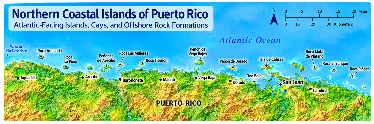
Northern Coastal Islands at a Glance
Puerto Rico's northern coastal islands include small offshore islets, rocky formations, and cays scattered along the Atlantic-facing coastline.
| Feature | Description |
|---|---|
| Location | Northern coast of Puerto Rico |
| Surrounding waters | Atlantic Ocean |
| Coastal geography | Limestone cliffs, rocky islets, reefs, and coastal formations |
| Notable areas | Arecibo, Barceloneta, Manatí, Vega Baja, Dorado, Toa Baja, and San Juan |
| Common formations | Rocky islets, sea stacks, coastal rocks, and small cays |
| Natural features | Wave-cut cliffs, limestone formations, coastal reefs, and seabird habitats |
| Accessibility | Many formations are inaccessible or best viewed from shore |
| Primary significance | Geology, coastal biodiversity, and maritime heritage |
Where Are Puerto Rico's Northern Coastal Islands?
Puerto Rico's northern coastal islands are scattered along the Atlantic-facing coastline, stretching from the northwestern shore toward the northeastern coast. Unlike the concentrated island groups of La Cordillera near Fajardo, these offshore formations do not form a single continuous chain.
Instead, they consist of small islands, rocky islets, offshore rocks, and coastal formations associated with different municipalities, including Aguadilla, Arecibo, Barceloneta, Manatí, Vega Baja, Dorado, Toa Baja, San Juan, and Carolina.
Much of Puerto Rico's northern coastline is influenced by the island's northern limestone belt, where coastal erosion and Atlantic wave action have helped shape cliffs, rocky headlands, and isolated offshore formations.
Some of these features are recognizable coastal landmarks, while others are small, uninhabited formations that are difficult to access or best observed from shore.
A Coast Shaped by the Atlantic
The northern coastline is exposed to Atlantic swells, particularly during the winter months. Waves, currents, and storms continually influence its beaches, rocky shorelines, and offshore formations.
Unlike the sheltered waters surrounding some of Puerto Rico's southern cays, many northern coastal formations experience stronger wave exposure, making them less suitable for recreational boating or landing.
Notable Northern Coastal Islands and Rock Formations
Puerto Rico's northern coastline includes a variety of small islands, rocky islets, and offshore formations with geological, ecological, and historical significance.
Some are recognizable coastal landmarks, while others are isolated rocks shaped by centuries of Atlantic wave action and coastal erosion.
Isla de Cabras — Toa Baja
Located near the entrance to San Juan Bay, Isla de Cabras is one of the most historically significant coastal landforms along Puerto Rico's northern coast.
The island is associated with Fortín San Juan de la Cruz, commonly known as El Cañuelo, a Spanish colonial fortification that helped defend the entrance to San Juan Bay.
Together with the fortifications across the bay, El Cañuelo formed part of the defensive system protecting Puerto Rico's capital during the Spanish colonial period.
Today, Isla de Cabras is connected to the mainland by a causeway and is associated with recreational and historical sites.
Other Northern Coastal Formations
Additional small offshore rocks and coastal formations occur along the Atlantic-facing shore, particularly in areas associated with the northern limestone belt.
Arecibo: The coastline features limestone cliffs, rocky headlands, and coastal formations influenced by Atlantic erosion.
Manatí: The municipality's northern shoreline includes limestone landscapes, rocky coastal features, and offshore formations.
Vega Baja: Coastal limestone and Atlantic wave action contribute to the area's distinctive rocky shoreline.
San Juan: The entrance to San Juan Bay includes historically important coastal landforms associated with Puerto Rico's maritime and defensive history.
Note: Individual offshore formations should be verified against geographic records before being added to a complete municipality-based directory.
How the Atlantic Ocean Shapes Puerto Rico's Northern Coast
The Atlantic Ocean has played an important role in shaping Puerto Rico's northern coastline. Powerful waves, coastal currents, and long-term erosion have contributed to the formation of limestone cliffs, rocky islets, coastal caves, and isolated offshore formations.
Unlike the smaller sandy cays found along parts of Puerto Rico's southern and eastern coasts, many northern coastal formations consist of exposed rock shaped by persistent wave action.
Limestone and Coastal Erosion
Much of northern Puerto Rico is characterized by limestone formations associated with the island's northern karst region.
Over time, rainwater gradually dissolves limestone, while ocean waves erode exposed coastal rocks. These processes contribute to the formation of coastal cliffs, caves, irregular shorelines, and isolated rock formations.
The interaction between geological structure and coastal erosion helps explain the dramatic landscapes found along sections of Puerto Rico's Atlantic coastline.
Sea Stacks and Rocky Islets
Some offshore rock formations are remnants of larger coastal landforms that have been separated from the mainland through erosion.
These isolated features are sometimes called sea stacks, although not every offshore rock or islet formed through the same geological process.
Their shapes and sizes depend on the composition of the rock, its resistance to erosion, and the intensity of wave exposure.
Atlantic Waves and Coastal Change
Puerto Rico's northern coast is exposed to Atlantic swells, particularly during the winter months.
Wave action can gradually reshape beaches, cliffs, and rocky shorelines, while hurricanes and major storms may cause more rapid coastal changes.
These natural processes make the northern coastline one of Puerto Rico's most dynamic coastal environments.
Not every offshore rock is an island. Some formations are sea stacks, exposed reefs, or isolated rocks that rise above the water. Their classification depends on their physical characteristics and geographic setting.
Wildlife and Coastal Ecosystems
Although many northern coastal islands and rocky islets are small, they can play an important role in Puerto Rico's coastal ecosystems.
Isolated offshore formations may provide resting or nesting habitats for seabirds, while surrounding submerged rocks and reefs support fish, crustaceans, and other marine organisms.
These environments also contribute to the ecological diversity of Puerto Rico's Atlantic coastline.
Why These Formations Matter
Seabird Habitats: Offshore rocks and small islets can provide relatively undisturbed resting and nesting areas for coastal birds.
Marine Ecosystems: Submerged rocks, reefs, and nearby marine habitats provide shelter and feeding areas for fish, invertebrates, and other marine species.
Geological Heritage: Rocky coastal formations provide visible evidence of erosion, geological processes, and the natural history of northern Puerto Rico.
Coastal Protection: Some offshore reefs and rocky formations help dissipate wave energy before it reaches nearby shorelines.
Environmental Challenges
Northern coastal ecosystems face pressures from coastal development, pollution, erosion, and changing marine conditions.
Strong storms and hurricanes can also alter small offshore formations and affect the habitats of species that depend on them.
Protecting these environments helps preserve Puerto Rico's coastal biodiversity and geological heritage.
Exploring Puerto Rico's Northern Coastal Formations
Unlike the eastern coastal islands near Fajardo, many northern coastal formations are not conventional boating or snorkeling destinations.
Instead, they are best appreciated from coastal viewpoints, beaches, historic sites, and designated recreational areas.
Viewing from Shore
Visitors can observe distinctive coastal formations from beaches and scenic overlooks along Puerto Rico's northern coastline.
Some locations offer opportunities to photograph limestone cliffs, rocky offshore formations, and the dramatic Atlantic shoreline.
Historic Coastal Sites
Isla de Cabras offers an opportunity to explore the relationship between Puerto Rico's coastal geography and its maritime history.
Its strategic location near San Juan Bay made it an important defensive position during the Spanish colonial period.
Safety and Conservation
Many northern coastal formations are exposed to strong Atlantic waves and currents. Visitors should exercise caution when exploring rocky coastal environments.
- Avoid climbing unstable coastal rocks or cliffs.
- Stay away from exposed rocks during strong surf.
- Do not attempt to reach isolated offshore formations without appropriate guidance.
- Respect protected wildlife habitats and nesting areas.
- Follow posted warnings and access restrictions.
- Use designated trails and coastal viewpoints where available.
Local Tip
Enjoy the Atlantic scenery from a safe distance. Puerto Rico's northern coast can be especially dramatic during periods of strong surf. However, unexpected waves can reach exposed rocks and coastal ledges. Choose established viewpoints and avoid approaching the water during hazardous conditions.
Northern Coastal Islands vs. Eastern Coastal Islands
Although Puerto Rico's northern and eastern coastal islands are both part of the Puerto Rican archipelago, they differ in geography, geological characteristics, and accessibility.
The Northern Coastal Islands consist primarily of scattered offshore rocks, small islets, and coastal formations along the Atlantic-facing shore.
The Eastern Coastal Islands are concentrated around La Cordillera near Fajardo, where small islands, cays, and coral reefs form a more recognizable offshore chain.
Comparing the Coastal Island Groups
| Feature | Northern Coastal Islands | Eastern Coastal Islands |
|---|---|---|
| Location | Atlantic-facing northern coastline | Northeastern coast near Fajardo |
| Geographic arrangement | Scattered coastal rocks and islets | La Cordillera island-and-reef chain |
| Typical formations | Rocky islets, sea stacks, limestone coastal features | Cays, small islands, coral reefs |
| Wave exposure | Many formations exposed to Atlantic swells | Varies depending on location and reef protection |
| Accessibility | Often viewed from shore | Several destinations accessible by boat |
| Popular activities | Coastal sightseeing, photography, historical exploration | Snorkeling, sailing, boating, day trips |
| Main interests | Geology, coastal scenery, maritime history | Marine biodiversity, recreation, conservation |
| Notable example | Isla de Cabras | Icacos, Palomino, Palominito |
Important Geographic Distinction
Puerto Rico's northern coastal islands are scattered along the Atlantic-facing shoreline, while the eastern coastal islands are concentrated around La Cordillera near Fajardo.
Both regions contribute to Puerto Rico's geographic diversity, but their coastal environments and recreational opportunities differ considerably.
Frequently Asked Questions
Find answers to common questions about Puerto Rico's northern coastal islands, their geology, accessibility, and ecological significance.
What are Puerto Rico's northern coastal islands?
Puerto Rico's northern coastal islands include small offshore islands, rocky islets, cays, and coastal formations located along the island's Atlantic-facing northern coastline. Many are uninhabited and are primarily significant for their geology and coastal ecosystems.
Where are the northern coastal islands located?
They are scattered along Puerto Rico's northern coastline, from the northwestern shore toward the northeastern coast. Unlike La Cordillera near Fajardo, they do not form a single continuous island chain.
Are there inhabited islands along Puerto Rico's northern coast?
Most small offshore formations along the northern coast are uninhabited. Some historically named islands, such as Isla de Cabras, are now connected to the mainland and are accessible by land.
What is Isla de Cabras?
Isla de Cabras is a historic coastal landform near the entrance to San Juan Bay in Toa Baja. It is associated with Fortín San Juan de la Cruz, also known as El Cañuelo, a Spanish colonial fortification that helped defend the bay.
Why are there so many rocky formations along the northern coast?
Puerto Rico's northern coastline has been shaped by Atlantic wave action, coastal erosion, and geological processes. Limestone formations, cliffs, and rocky headlands have contributed to the development of isolated offshore rocks and other coastal features.
Can you visit Puerto Rico's northern offshore islands?
Accessibility varies by location. Some coastal landmarks are accessible by land or can be viewed from public beaches and scenic overlooks. Many offshore rocks and islets are inaccessible, environmentally sensitive, or unsafe to approach.
Are the northern coastal islands part of La Cordillera?
No. La Cordillera is a separate island-and-reef system located off Puerto Rico's northeastern coast near Fajardo. The northern coastal islands are scattered along the Atlantic-facing shoreline.
What makes the northern coast different from Puerto Rico's southern coast?
Puerto Rico's northern coast faces the Atlantic Ocean and includes extensive limestone landscapes, rocky formations, and areas exposed to strong ocean swells. Much of the southern coast faces the Caribbean Sea and has different coastal environments, including mangroves, shallow bays, and offshore cays.
Continue Exploring Puerto Rico
North Coast
Explore Puerto Rico's North Coast, home to Atlantic beaches, dramatic karst landscapes, caves, and communities stretching west from San Juan.
East Coast
Discover Puerto Rico's East Coast, where El Yunque, Luquillo's beaches, Fajardo, and coastal nature reserves create endless opportunities for outdoor adventure.
Central Mountains
Journey into Puerto Rico's Central Mountains for coffee country, cooler temperatures, scenic roads, forests, and traditional mountain towns.
Metro Area
Experience Puerto Rico's Metro Area, home to San Juan, historic Old San Juan, beaches, museums, restaurants, nightlife, shopping, and the island's largest urban center.
West Coast
Head to Puerto Rico's West Coast for legendary surfing, beautiful sunsets, beaches, and lively coastal towns such as Rincón and Mayagüez.
South Coast
Explore Puerto Rico's South Coast for historic Ponce, Caribbean beaches, dry forests, coastal communities, and a slower pace.
Did You Know?
Puerto Rico was under Spanish rule for almost 400 years.
Get Our Newsletter
Discover new places, local flavors, upcoming events, cultural stories, and some of our favorite finds from around the island.Read the Latest ¡La Isla! Newsletter
Follow Along


