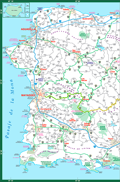
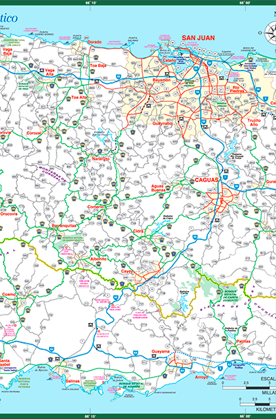
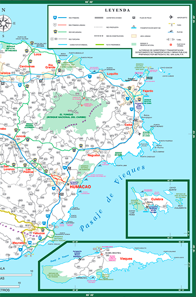
Puerto Rico's Highway and Road Maps
Whether you're planning a road trip, navigating the island's cities, or heading off the beaten path, having a reliable map of Puerto Rico's highways and roads is essential. The Puerto Rico Department of Transportation and Public Works (DTOP) provides detailed, free maps to help residents and visitors easily travel across the island.
The maps are in PDF format and require the Acrobat Reader to view them. Tap on the map to enlarge the map to the full screen.
What's Included in the Maps?
The official road maps cover all cities, towns, major highways, toll roads, scenic routes, major lakes, rivers, and streams in Puerto Rico, making it easier to plan your route.
Need directions? Use google maps for step-by-step instructions.
Source: Mapa de Carreteras by DTOP
Understanding Puerto Rico's Roads & Highways
Major Highways & Expressways (Autopistas)
- PR-52 (Luis A. Ferr&ecute; Expressway) - Connects San Juan to Ponce, passing through Caguas and Cayey.
- PR-22 (José de Diego Expressway) - Runs along the northern coast from San Juan to Arecibo and Aguadilla.
- PR-66 (Roberto S&aacut;nchez Vilella Expressway) - Provides an easier route from San Juan to the eastern coast, including Fajardo.
- PR-2 (Puerto Rico Route 2) - The longest highway, connecting cities along the north and west coasts.
- PR-53 (Eastern Coastal Highway) - Runs along the southeast coast, serving towns like Humacao and Guayama.
Scenic & Regional Roads
- Ruta Panorámica (PR-143, PR-144, PR-149, and PR-105) - A stunning mountain drive across the island's central region.
- PR-187 & PR-165 - Coastal roads with beautiful ocean views and access to hidden beaches.
Toll Roads in Puerto Rico
Some expressways in Puerto Rico require a toll payment. To drive on these roads, travelers can use an AutoExpreso tag, similar to an E-ZPass. If you're renting a car, check with your rental company about toll payment options.