
Where Is Puerto Rico?
Puerto Rico is a Caribbean island located between the Caribbean Sea and the North Atlantic Ocean, about 1,000 miles (1,600 km) southeast of Miami, Florida. It lies approximately 50 miles (80 km) east of the Dominican Republic, 40 miles (65 km) west of the U.S. Virgin Islands. Its approximate geographical coordinates are 18.2° N latitude and 66.5° W longitude.
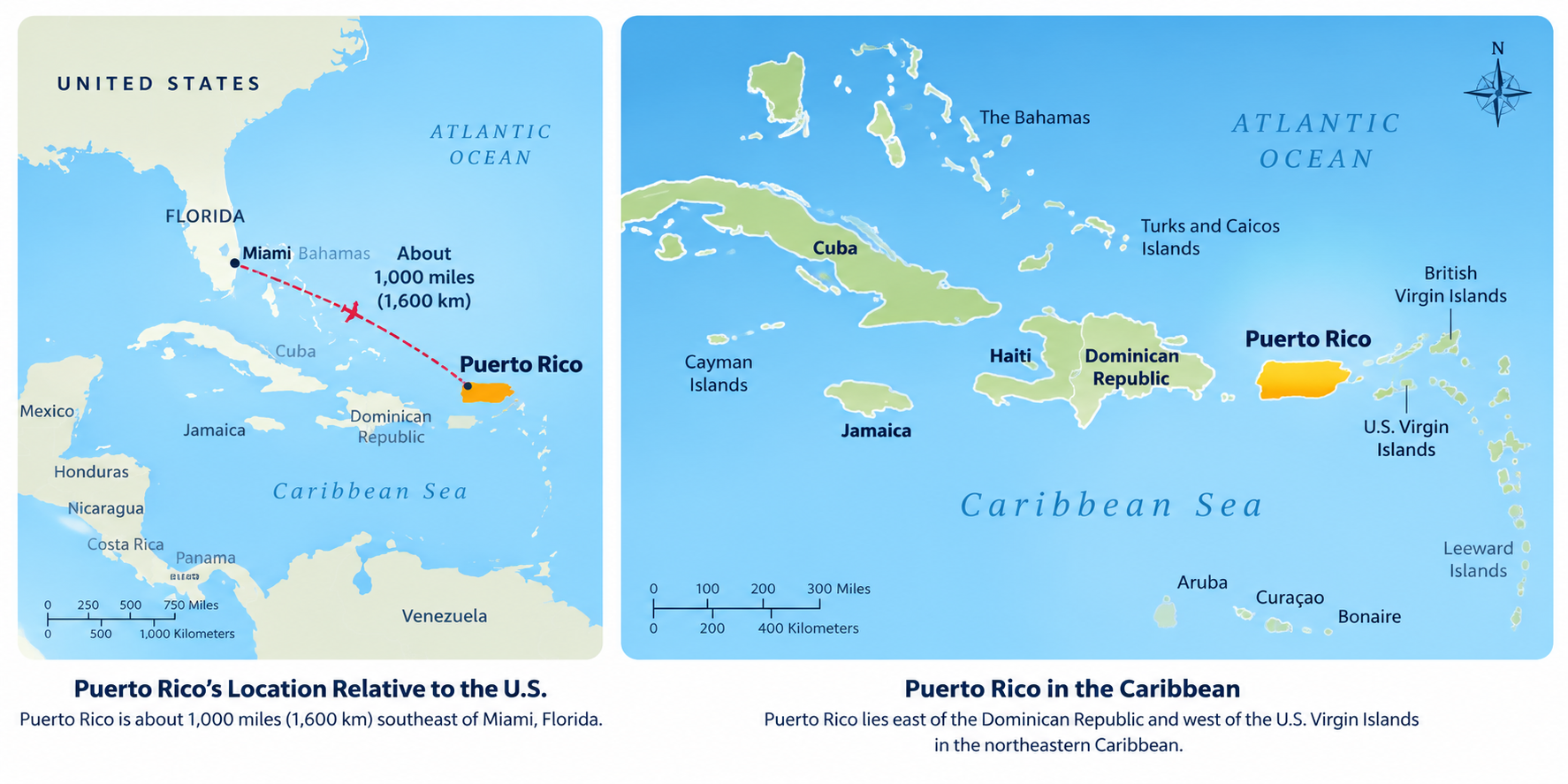
Where Is Puerto Rico in the Caribbean?
The island is located in the Caribbean, between the Caribbean Sea and the North Atlantic Ocean, east of the Dominican Republic, about 1,000 miles (1,600 km) southeast of Miami, Florida. Puerto Rico is one of the 28 islands in the Caribbean.
Puerto Rico is the easternmost of the Greater Antilles, the Caribbean island group that also includes Cuba, Hispaniola—home to the Dominican Republic and Haiti—and Jamaica. The U.S. Virgin Islands lie just east of Puerto Rico, while the Dominican Republic is across the Mona Passage to the west.
Puerto Rico is almost rectangular in shape, approximately 100 miles long by 35 miles wide and is the smallest and the most eastern island of the Greater Antilles (Cuba, Hispaniola, Jamaica and Puerto Rico).
Although, often referred an island, Puerto Rico is an archipelago formed by the main island and 143 small islands, islets and cays, including Vieques, Culebra, Culebrita, Palomino, Mona, and Monito. Vieques and Culebra are also known by some by the Spanish Virgin Islands, formerly called the Passage Islands and also known as the Puerto Rican Virgin Islands.
Its coasts measures approximately 435 km, and if the adjacent islands Vieques and Culebra are included the coast measures approximately 700 km. With an area of 3,425 square miles (9,104 sq km), Puerto Rico is the third largest island in the United States and the 82nd largest island in the world.
3rd largest island in the U.S. (after Hawaii and Kodiak Island, Alaska)
Atlantic Standard Time (AST), UTC-4 year-round (no daylight saving)
Vieques, Culebra, and Mona Island are the largest offshore territories
~900 people per square mile, one of the most densely populated islands
Location & Size
The island of Puerto Rico is a very popular tourist destination because of its location, rich history and warm atmostphere. Puerto Rico is strategically positioned in the northeastern Caribbean Sea.
Puerto Rico is approximately 100 miles (160 km) from east to west and 35 miles (56 km) from north to south.
Geographic Position
Coordinates
Latitude: 18° 15" N Longitude: 66° 30" W
Location
- Easternmost island of the Greater Antilles
- Between the Caribbean Sea and Atlantic Ocean
- 1,000 miles southeast of Miami, Florida
- West of the U.S. Virgin Islands
- East of Hispaniola (Dominican Republic/Haiti)
Region
North America
Subregion
Caribbean
Map References
Central America and the Caribbean
Limits
To the west by Haití and the Dominican Republic (La
Hispañola), separated by the Mona Passage ("Mona Canal"), to
the east by the Virgin Islands, to the north by the Atlantic Ocean, and to the
south by the Caribbean Sea.
Dimensions
Land Area
3,459 sq mi (8,959 sq km)
Roughly the size of Connecticut or three times the size of Rhode Island
Water Area
145 sq km
Island Measurements
- Length: 100 miles (160 km) east to west
- Width: 35 miles (56 km) north to south
- Coastline: 270 miles (435 km)
- Offshore Islands: Over 140 smaller islands
Land boundaries
0 km
Borders
Puerto Rico is under the U.S. customs jurisdiction. Borders are
open between P.R. and the U.S., allowing for free movement of people and
merchandise.
Maritime Claims
Continental shelf: 200 NM (depth)
Exclusive economic zone: 200 NM
Territorial sea: 12 NM
Learn more about Puerto Rico's islands and cays, topography, and coastal geography.
Puerto Rico Is More Than One Island
Puerto Rico is an archipelago, not just one island. The main island is surrounded by smaller islands and cays. Among the most notable are Vieques and Culebra, both popular for their beautiful beaches and natural reserves, as well as Mona Island, an ecological sanctuary often referred to as the "Galápagos of the Caribbean." Other lesser-known islands like Monito, Caja de Muertos, and Icacos add to Puerto Rico's rich and diverse geographical landscape.
How Far Is Puerto Rico from the U.S.?
- Miami → Puerto Rico: about 1,000 miles
- New York → Puerto Rico: about 1,600 miles
- Dominican Republic → Puerto Rico: about 80 miles across the Mona Passage at the closest major-island points
Puerto Rico is part of the Caribbean and is an unincorporated territory of the United States. People born in Puerto Rico are U.S. citizens, and travelers arriving from the U.S. mainland are traveling within the United States.
Puerto Rico's unique location makes it a cultural crossroads between the Americas and a key gateway to the Caribbean. Whether you're looking to explore its vibrant cities, historical landmarks, or natural wonders, the island's position offers both accessibility and adventure.
Explore Puerto Rico's Geography.
Continue Exploring Puerto Rico
Geography
Discover Puerto Rico's mountains, rivers, forests, coastlines, islands, and natural regions.
Did You Know?
Puerto Rico has three bioluminescent bays, more than any other place in the world.
Get Our Newsletter
Discover new places, local flavors, upcoming events, cultural stories, and some of our favorite finds from around the island.Read the Latest ¡La Isla! Newsletter
Follow Along


