Aguas Buenas, Puerto Rico

Known as "La Ciudad de las Aguas Claras" (The City of Clear Waters), because of the purity of its fresh water springs. Originally named Aguabuena, a sector of Caguas, later in 1798, became Aguas Claras as residents started establishing houses near the area.
Aguas Buenas is a scenic mountain municipality nestled in Puerto Rico's Central Mountain Range. Surrounded by lush forests, winding rivers, and breathtaking overlooks, the town offers visitors a peaceful escape just a short drive from the San Juan metropolitan area. Whether you're hiking through nature, enjoying panoramic mountain views, or discovering local traditions, Aguas Buenas showcases the quieter side of Puerto Rico.
Overview
Why Visit Aguas Buenas?
Aguas Buenas is an ideal destination for travelers looking to experience Puerto Rico's mountain landscapes, fresh air, and authentic small-town charm. Known for its natural springs, scenic overlooks, outdoor recreation, and welcoming community, the municipality offers a relaxing retreat while remaining conveniently close to the island's capital.
Top Attractions in Aguas Buenas
Mirador La Piedra Degetau
Perched high above the surrounding mountains, Mirador La Piedra Degetau offers sweeping panoramic views of Puerto Rico's Central Mountain Range. On clear days, visitors can enjoy spectacular scenery stretching toward the northern coast, making it one of the municipality's favorite scenic overlooks.
Plaza de Recreo Luis Muñoz Marín
The heart of downtown Aguas Buenas, Plaza de Recreo Luis Muñoz Marín is surrounded by historic buildings, local cafés, and small businesses. Throughout the year, the plaza hosts concerts, festivals, holiday celebrations, and community gatherings.
Iglesia Nuestra Señora de la Monserrate
Built in the early twentieth century, Iglesia Nuestra Señora de la Monserrate serves as one of Aguas Buenas' most recognizable landmarks. Its elegant architecture and prominent location overlooking the town plaza make it an important symbol of the municipality's religious and cultural heritage.
Charco El Roble
Nestled within the municipality's lush interior, Charco El Roble is a natural swimming hole surrounded by tropical vegetation. Its refreshing waters and peaceful setting make it a popular destination for locals seeking a quiet escape into nature.
Cerro La Tisa
One of the municipality's highest elevations, Cerro La Tisa rewards hikers with impressive mountain vistas and opportunities to observe Puerto Rico's native flora and wildlife. The area is especially popular among outdoor enthusiasts and nature photographers.
Hacienda La Esperanza
A reminder of Aguas Buenas' agricultural heritage, Hacienda La Esperanza reflects the municipality's long history of coffee cultivation and rural life in Puerto Rico's central mountains.
Ruta de los Chinchorros
Visitors can explore Aguas Buenas through its collection of traditional chinchorros, where local restaurants serve Puerto Rican specialties while offering beautiful mountain views and a relaxed atmosphere.
Plan your Visit
Whether you're planning a scenic day trip or a relaxing mountain getaway, Aguas Buenas offers easy access from the San Juan metropolitan area while providing a peaceful escape into Puerto Rico's central highlands.
Getting There
By Air
Luis Muñoz Marín International Airport (SJU) in San Juan is approximately 30 minutes from Aguas Buenas, making the municipality one of the most accessible mountain destinations on the island.
By Car
Aguas Buenas is easily reached via PR-156, connecting the municipality with Caguas, Bayamón, and San Juan.
Getting Around
Rental Car
A rental car is highly recommended for exploring the municipality's scenic roads, mountain attractions, and nearby communities.
Public Transportation
Public transportation is limited. Visitors should plan on driving or using taxis and ride-sharing services when available.
Walking
Downtown Aguas Buenas is compact and easily explored on foot, especially around the central plaza and historic district.
Nature & Resources
Geography
Located in Puerto Rico's Central Mountain Range, Aguas Buenas borders Cidra to the south, Caguas to the east, Comerío to the west, and Bayamón and Guaynabo to the north. The municipality is characterized by rolling mountains, fertile valleys, winding rivers, and abundant forests that contribute to its nickname, "The City of Clear Waters."
Several rivers flow through Aguas Buenas, contributing to its lush landscapes and abundant natural resources. Portions of the Bayamón River originate within the municipality, while the Bairoa, Cagüitas, and Cañas rivers form part of the Río Grande de Loíza watershed, one of Puerto Rico's most important river systems. These waterways have long supported the municipality's agriculture, biodiversity, and reputation as the "City of Clear Waters."
Aguas Buenas' highest peaks are La Peña (552 m), Santa Bárbara (510 m), and Chícharo (490 m).
Neighborhoods & Barrios
Aguas Buenas consists of 10 barrios (PDF) (wards/districts):
- Bairoa
- Bayamóncito
- Cagüitas
- Jagüeyes
- Juan Ascencio
- Mulas
- Mulitas
- Pueblo
- Sonadora
- Sumidero
Climate
Aguas Buenas enjoys a tropical mountain climate, with slightly cooler temperatures than Puerto Rico's coastal communities due to its higher elevation. Average daytime temperatures generally range from the upper 70s°F (mid-20s°C) in winter to the mid-80s°F (around 30°C) during the summer. Rainfall is common throughout the year, helping create the lush green landscapes and clear streams for which the municipality is known. Aguas Buenas annual precipitation is 66.5 inches, and its average temperature is 75°F. June is the warmest, February is the coldest, November is the wettest, and March is the driest month.
Local Tip
Bring a light jacket if you're visiting in the evening. The higher elevation often brings cooler temperatures and refreshing mountain breezes after sunset.
AGUAS BUENAS WEATHER10 Day Forecast from weather.com
Where to Stay
- Hacienda Siempre Viva
- Canyon Boutique Hotel
- Finca Victoria
- Casa de Campo Aguas Buenas
- Villa Campestre
- Mountain cabins
- Country homes
Local Flavors & Festivities
Where to Eat
- El Panorámico
- El Rancho de Don Nando
- La Casona Criolla
- Restaurante El Bohío
- Sirimiri Café
- Panadería La Monserrate
- Panadería y Repostería La Familia
- Punto Criollo
- El Patio Gastrobar
- La Terraza Restaurant & Bar
Festivals and Events
Displaying 3 results.
- Aguas Buenas Carnival - March
- Festival Folklorico de Campo y Pueblo - January
-
Fiestas Patronales Nuestra Senora de la Monserrate
- September
Every year, Aguas Buenas celebrates a patron saint festival. The festivities include dances, food, parades and religious processions.(787) 732-8621
History
Founded in May 25, 1838, by Francisco de Salas Torres, who was declared the first city mayor. Aguas Buenas developed as a rural farming community known for its fertile lands and abundant natural springs. Coffee cultivation, tobacco farming, and agriculture played an important role in the municipality's early economy. Over time, its strategic location between the mountains and the San Juan metropolitan area helped shape its growth while preserving its peaceful rural character. Today, Aguas Buenas remains known for its natural beauty, community traditions, and rich agricultural heritage.
Moments in History
Coffee and tobacco become important economic activities.
Road improvements strengthen connections with neighboring municipalities.
Residential growth increases due to proximity to the San Juan metropolitan area.
Aguas Buenas is recognized for its mountain scenery, outdoor recreation, and community festivals.
Notable People
Throughout its history, Aguas Buenas has been home to accomplished journalists, educators, artists, musicians, physicians, and public servants whose achievements have contributed to Puerto Rico's cultural and civic life. Their work continues to reflect the municipality's strong commitment to education, creativity, and public service.
Famous Aguasbonenses
Isaac Córdova Chávez
1914–1993
Journalism • Literature
A respected journalist, columnist, and writer, Isaac Córdova Chávez devoted much of his career to documenting Puerto Rico's culture, politics, and society. His thoughtful commentary and literary work earned him recognition as one of Aguas Buenas' most distinguished intellectuals.
Gustavo Muñiz Díaz
1904–1986
Medicine
Dr. Gustavo Muñiz Díaz was a highly respected physician who dedicated his life to improving healthcare in Puerto Rico. His commitment to public health and patient care made him a well-known figure throughout the island.
Luis Rafael Arcelay
1930–2011
Theater • Literature
A playwright, dramatist, and educator, Luis Rafael Arcelay made important contributions to Puerto Rican theater through works that explored the island's culture, history, and social issues. His plays continue to be appreciated by students and theater enthusiasts.
Rafael Nicolau
1929–2009
Journalism
Rafael Nicolau was an accomplished journalist whose reporting and editorial work helped inform Puerto Rican audiences for decades. His dedication to responsible journalism earned him widespread professional respect.
Pico Rechani
1915–1999
Journalism
Pico Rechani became well known for his work as a journalist and broadcaster, covering important events while promoting Puerto Rican culture and public affairs through the media.
City Symbols
Aguas Buenas' official symbols celebrate the municipality's natural beauty, agricultural heritage, and strong community spirit. Together, the flag, coat of arms, and anthem reflect the clear waters, fertile mountains, and traditions that have shaped the municipality since its founding in 1838.
Flag
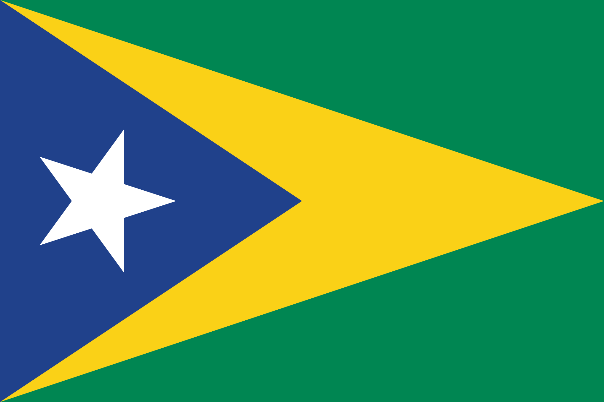
The flag of Aguas Buenas consists of a large green triangle symbolizing the municipality's fertile mountains and abundant vegetation. A yellow triangle represents prosperity and hope, while a blue triangle reflects the municipality's clear rivers and streams that inspired its nickname, "La Ciudad de las Aguas Claras." A white star honors the municipality itself and its place among Puerto Rico's seventy-eight municipalities.
Coat of Arms
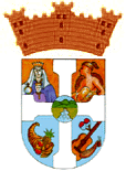
The coat of arms of Aguas Buenas incorporates symbols representing the municipality's history and natural environment. Indigenous motifs honor the region's Taíno heritage, while water represents the clear springs and rivers that inspired the municipality's name. Agricultural elements recognize the importance of farming and coffee cultivation, and the mural crown signifies Aguas Buenas' status as an incorporated municipality.
Anthem
The official anthem of Aguas Buenas is "Aguas Claras," written by Ramón Berríos. The anthem celebrates the municipality's beautiful mountain scenery, abundant waters, and the pride of its people. It is performed during civic ceremonies, festivals, and other official events as a symbol of the community's identity and heritage.
Written by Ramon Cintron. Aguas Claras.
Human & Capital Resources
Economy
Historically rooted in agriculture, Aguas Buenas has evolved into a diverse local economy supported by retail, healthcare, education, construction, and small businesses. Many residents also commute to nearby Caguas and the San Juan metropolitan area for employment, while tourism and outdoor recreation continue to contribute to the municipality's economic growth.
Education
Education has long been an important part of Aguas Buenas' development. The municipality is served by several public and private elementary and secondary schools operated by the Puerto Rico Department of Education. Residents also have convenient access to colleges and universities in nearby Caguas, Bayamón, and San Juan, providing opportunities for higher education throughout the region.
Demographics *
Population
24,223
Land Area: 30.08 sq mi
Density: 840.9 per sq mi
Median Age: 42.6
Sex: 51% female
Economics **
$12,245
Median household income: $20,190
Puerto Rico: $21,058
Persons below poverty line: 44.8%
Housing, families and educational attainment *
Number of households
8,629
Housing units density:
382 (2013)
Persons per household: 2.91
High school grad or higher: 72.7%
Marital status: 39% married
* U.S. Census Bureau 2020 data, unless otherwise noted - Source: Quick Facts Puerto Rico.
** U.S. Census Bureau 2016-2020
Map References
Coordinates: 18.2569° N, 66.1031° W
ZIP Code: 703
Driving Distance from San Juan: 21.3 miles
Driving Time: 43 minutes
Frequently Asked Questions
What is Aguas Buenas known for?
Aguas Buenas is known for its beautiful mountain scenery, clear rivers and springs, outdoor recreation, and its nickname, "La Ciudad de las Aguas Claras" (The City of Clear Waters).
Why is Aguas Buenas called the City of Clear Waters?
The municipality received its nickname because of the abundance of clean rivers, streams, and natural springs that flow through the surrounding mountains.
Is Aguas Buenas worth visiting?
Yes. Aguas Buenas offers beautiful mountain landscapes, scenic overlooks, local cuisine, hiking opportunities, and a peaceful atmosphere just a short drive from San Juan.
What are the top attractions in Aguas Buenas?
Popular attractions include Mirador La Piedra Degetau, Iglesia Nuestra Señora de la Monserrate, Plaza de Recreo Luis Muñoz Marín, Charco El Roble, and several scenic mountain routes.
How far is Aguas Buenas from San Juan?
Aguas Buenas is located about 25 miles (40 km) south of San Juan, approximately a 35- to 45-minute drive, depending on traffic.
What airport is closest to Aguas Buenas?
Luis Muñoz Marín International Airport (SJU) is the closest airport and is approximately 30 minutes away by car.
What outdoor activities can you enjoy in Aguas Buenas?
Visitors can enjoy hiking, mountain drives, nature photography, birdwatching, scenic overlooks, and exploring rivers and natural swimming areas.
When is the best time to visit Aguas Buenas?
Aguas Buenas can be visited year-round. The cooler mountain temperatures make it especially enjoyable during the winter months and after seasonal rains when the landscape is at its greenest.
Does Aguas Buenas have a historic downtown?
Yes. The town center features Plaza Luis Muñoz Marín, Iglesia Nuestra Señora de la Monserrate, local shops, restaurants, and municipal buildings that reflect the community's history and charm.
Can Aguas Buenas be visited as a day trip?
Absolutely. Its close proximity to San Juan, Caguas, and Bayamón makes Aguas Buenas an excellent day trip destination for visitors looking to experience Puerto Rico's scenic central mountains.
Did You Know?
The lamb on the seal represents Saint John the Baptist, for whom the island was originally named San Juan Bautista.
This is your comprehensive guide to La Isla del Encanto.