Comerio, Puerto Rico
(ko-me-REE-o)
Known as "El Paraíso entre Montañas" (Paradise Among the Mountains) and "La Perla de La Plata" (The Pearl of La Plata), Comerío is a picturesque municipality nestled in Puerto Rico's Central Mountain Region. Originally named "Sabana del Palmar", but later changed to Comerío, named after a local Indian chief Comerio.
Surrounded by lush forests, rivers, waterfalls, and dramatic mountain scenery, Comerío offers visitors an authentic rural experience just under an hour from San Juan. Rich in history, outdoor recreation, and cultural traditions, the municipality invites travelers to discover scenic overlooks, historic hydroelectric dams, natural pools, caves, and welcoming mountain communities.
Overview
Why Visit Comerío?
Comerío is an ideal destination for travelers seeking nature, adventure, and authentic Puerto Rican culture. Scenic mountain roads lead to waterfalls, rivers, panoramic viewpoints, and one of Puerto Rico's oldest hydroelectric complexes. The municipality is also home to La Ruta de las Siete Maravillas (The Route of the Seven Wonders), a self-guided journey connecting many of Comerío's most beautiful natural and historic attractions. Whether you're hiking, swimming in natural pools, enjoying a traditional chinchorreo, or simply taking in the mountain views, Comerío offers a memorable escape into Puerto Rico's countryside.
Top Attractions in Cabo Rojo
La Ruta de las Siete Maravillas
Comerío's signature scenic route connects many of the municipality's most spectacular attractions, including waterfalls, rivers, caves, historic landmarks, and panoramic overlooks. It is one of the best ways to experience the municipality's natural beauty.
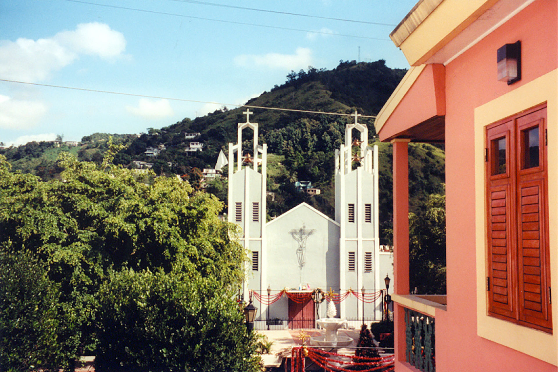
Photo: Manuel Santiago
El Salto Hydroelectric Dams
Built in the early twentieth century, El Salto I and El Salto II are among Puerto Rico's oldest hydroelectric facilities. The nearby Mirador El Salto offers breathtaking views of the dams surrounded by steep mountain cliffs and lush vegetation.
Río La Plata
Puerto Rico's longest river flows through Comerío, providing beautiful scenery and opportunities for photography, picnicking, and nature appreciation. The river has played an essential role in the municipality's history and development.
Charco Las Pailas
Fed by the Río Hondo, Charco Las Pailas features crystal-clear natural pools, small waterfalls, and smooth rock formations that make it one of Comerío's favorite places to cool off on warm days.
Cañón Las Bocas
This impressive canyon between Comerío and Barranquitas offers waterfalls, rivers, caves, and dense forests. Guided excursions allow visitors to explore one of the municipality's most scenic natural landscapes.
Cuevas de la Mora
This archaeological cave system contains ancient Taíno petroglyphs and pictographs, making it one of Puerto Rico's most important pre-Columbian cultural sites. Guided tours are available.
Media Luna Recreational Area
Perfect for families, Media Luna offers picnic facilities, swimming pools, playgrounds, walking areas, and seasonal water attractions surrounded by beautiful mountain scenery.
Cruz de Monte Limón
Standing atop one of Comerío's highest peaks, this illuminated cross has become one of the municipality's best-known landmarks and offers panoramic views of the surrounding mountains.
Plan your Visit
Whether you're visiting for a few hours or planning a weekend getaway, Comerío offers beautiful mountain scenery, outdoor adventures, and authentic Puerto Rican culture.
Getting There
By Air
Luis Muñoz Marín International Airport (SJU) is approximately one hour from Comerío.
By Car
Comerío is easily reached via PR-167, PR-156, and PR-779, connecting the municipality with Bayamón, Barranquitas, Cidra, and Aguas Buenas.
Getting Around
Rental Car
A rental car is highly recommended since many attractions are located throughout the mountains.
Taxis & Rideshare
Taxis and rideshare may be available, but service can be limited compared with San Juan.
Walking
The downtown plaza, church, and local businesses are easily explored on foot.
Nature & Resources
Geography
Comerío lies in Puerto Rico's Central Mountain Region and is bordered by Naranjito, Bayamón, Aguas Buenas, Cidra, and Barranquitas. The municipality's landscape is characterized by rugged mountains, deep valleys, rivers, and forests. The Río La Plata and Río Hondo have carved dramatic scenery that supports rich ecosystems and numerous outdoor recreation areas
Neighborhoods & Barrios
Comerio is made up of 9 barrios (PDF) (wards/districts):
- Cedrito
- Cejas
- Doña Elena
- Nananjo
- Palomas
- Piñas
- Pueblo
- Río Hondo
- Vega Redonda
Climate
Thanks to its higher elevation, Comerío enjoys warm days, cool evenings, and abundant rainfall that keeps the mountains lush throughout the year. The pleasant climate makes hiking and outdoor recreation enjoyable in every season.
Comerio annual precipitation is 65 inches, and its average temperature is 76°. The driest month is March, and the wetest is October. The warmest month is August, and the coolest is February.
10 Day Forecast from weather.com
Where to Stay
- Hotel Media Luna
Several eco-lodges and rural accommodations nearby offer immersive experiences in Puerto Rico's Central Mountain Region.
Vacation rentals are popular with families, groups, and travelers planning extended beach vacations.
Local Flavors & Festivities
Where to Eat
- Bar Doña Elena
- Luna Montuna Restaurant
- Restaurante La Barranca
- El Jardín Burger
- Alfonsina Mexican Fusion
- Comerío Fried Chicken
One of the best ways to experience Comerío is by stopping at the many roadside eateries along the Route of the Seven Wonders, where you'll find smoked meats, fritters, local desserts, and traditional Puerto Rican dishes.
Festivals and Events
Displaying 5 results.
- Carnaval de Primavera - April
-
Carnaval del Plata
- February
Traditional mountain carnival with music, dancing, colorful costumes, artisan markets, local cuisine, and family-oriented festivities.
- Festival Jibaro - June
- Fiestas de San Andres Apostol - November
-
Fiestas Patronales Santo Cristo de la Salud
- August
Every year, Comerio celebrates a patron saint festival. The festivities include dances, food, parades and religious processions.(787) 875-3445
History
Founded on June 12, 1826, Comerío developed as an agricultural community along the banks of the Río La Plata. The municipality's fertile valleys supported tobacco, coffee, and other crops, helping establish it as an important farming region in Puerto Rico's central mountains. During the early twentieth century, Comerío gained additional importance with the construction of the El Salto Hydroelectric Project, one of Puerto Rico's earliest hydroelectric systems. Today, the municipality preserves its agricultural traditions while embracing eco-tourism and outdoor recreation.
Moments in History
Comerío is officially founded.
Tobacco and coffee become the municipality's principal agricultural products.
El Salto Hydroelectric Project begins producing electricity, becoming one of Puerto Rico's earliest hydroelectric facilities.
Cruz de Monte Limón is erected, becoming one of Comerío's best-known landmarks.
La Ruta de las Siete Maravillas is established to promote eco-tourism and the municipality's natural attractions.
Comerío is recognized as one of Puerto Rico's premier mountain destinations, celebrated for its rivers, waterfalls, caves, and outdoor adventures.
Notable People
Comerío has produced distinguished educators, physicians, artists, military leaders, and public servants whose accomplishments have contributed to Puerto Rico's cultural, scientific, and civic life.
Famous Caomerioeños
Juana Colón
1886–1967
Labor Leader • Women's Rights
Known as the "Joan of Arc of Comerío," Juana Colón was a labor organizer, suffragist, and advocate for workers' rights who became one of Puerto Rico's most influential social activists.
Blanca de Castejón
1906–1969
Actress
Blanca de Castejón enjoyed a successful career during the Golden Age of Mexican cinema and became one of Puerto Rico's pioneering actresses in film and theater.
Enrique Pérez Santiago
1916–1996
Medicine
An internationally respected hematologist and medical researcher, Dr. Enrique Pérez Santiago made significant contributions to public health and medical education in Puerto Rico.
City Symbols
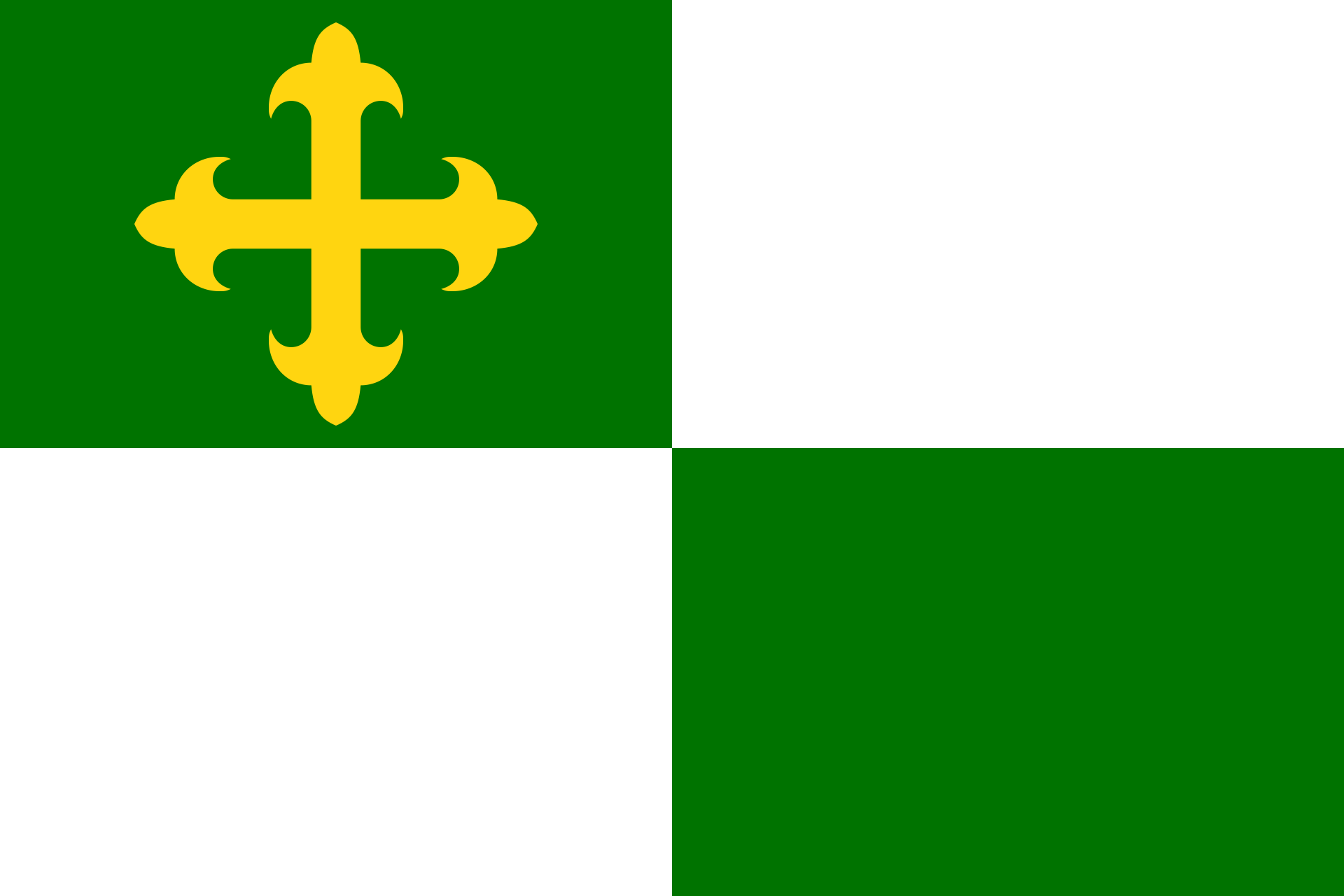
Flag
Comerío's flag is divided into four rectangles of green and white. A golden cross appears in the upper-left quadrant, honoring the municipality's patron saint, Santo Cristo de la Salud, while the green fields represent the lush mountains surrounding the town.
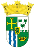
Coat of Arms
The coat of arms features a golden cross, tobacco leaves recalling Comerío's agricultural heritage, royal palms representing the municipality's original name, blue waves symbolizing the Río La Plata, and a Taíno-inspired crown honoring the indigenous chief Comerío. A mural crown identifies the municipality as one of Puerto Rico's seventy-eight municipalities.
Anthem
The official anthem of Comerío is "Con alma henchida de amor y esperanza" ("With a Soul Filled with Love and Hope"), with lyrics by Dr. Francisco Manrique Cabrera. The anthem expresses the pride, resilience, and strong community spirit of Comerío while celebrating its beautiful mountains, rich history, and the hardworking people who have shaped the municipality through generations. It is traditionally performed during civic ceremonies, cultural celebrations, and municipal events, serving as a musical tribute to the town's enduring heritage.
Con alma henchida de amor y ensueño....
Human & Capital Resources
Economy
Agriculture has long been the foundation of Comerío's economy. Tobacco once dominated local production, earning the municipality the nickname "El Pueblo del Tabaco", while coffee and livestock also played significant roles. Today, the economy has diversified to include retail businesses, government services, manufacturing, healthcare, construction, and tourism. Outdoor recreation, cultural tourism, and local restaurants continue to attract visitors exploring Puerto Rico's Central Mountain Region.
Education
Comerío is served by public and private schools that provide educational opportunities from elementary through high school. Students pursuing higher education benefit from nearby institutions in Bayamón, Caguas, and Barranquitas, as well as the University of Puerto Rico system. Community libraries, cultural organizations, and environmental education programs help preserve the municipality's rich history while promoting lifelong learning.
Demographics *
Population
18,883
Land Area: 28.4 sq mi
Density: 667 per sq mi
Median Age: 40.6
Sex: 51% female
Economics **
$7,746
Median household income: $14,297
Puerto Rico: $21,058
Persons below poverty line: 53.7%
Housing, families and educational attainment *
Number of households
5,264
Housing units density:
284.9 (2013)
Persons per household: 3.6
High school grad or higher: 71%
Marital status: 28% married
* U.S. Census Bureau 2020 data, unless otherwise noted - Source: Quick Facts Puerto Rico.
** U.S. Census Bureau 2016-2020
Map References
Coordinates: 18.2181° N, 66.2261° W
ZIP Code: 782
Driving Distance from San Juan: 31.8 miles
Driving Time: 1 hour, 5 minutes
Frequently Asked Questions
What is Comerío known for?
Comerío is known for its spectacular mountain scenery, the Route of the Seven Wonders, El Salto Hydroelectric Complex, Río La Plata, and its nickname, "Paradise Among the Mountains."
Where is Comerío located?
Comerío is located in Puerto Rico's Central Mountain Region, about an hour southwest of San Juan, bordered by Barranquitas, Cidra, Aguas Buenas, Naranjito, and Bayamón.
What are the best things to do in Comerío?
Visitors can drive the Route of the Seven Wonders, visit the El Salto Hydroelectric Complex, hike to scenic viewpoints, swim in natural pools, explore caves, and enjoy traditional Puerto Rican cuisine at local restaurants and chinchorros.
What is the Route of the Seven Wonders?
The Route of the Seven Wonders is a scenic driving route that connects many of Comerío's most popular natural and historic attractions, including rivers, waterfalls, viewpoints, caves, and the historic hydroelectric complex.
Is Comerío a good destination for outdoor activities?
Yes. Comerío is one of Puerto Rico's top mountain destinations for hiking, river exploration, birdwatching, photography, scenic drives, and nature excursions.
Why is Comerío called "Paradise Among the Mountains"?
The nickname reflects Comerío's lush mountain landscapes, rivers, waterfalls, pleasant climate, and peaceful rural atmosphere that make it one of Puerto Rico's most scenic municipalities.
Did You Know?
More than 50% of Puerto Rico's total exports are in the pharmaceutical sector.
This is your comprehensive guide to La Isla del Encanto.