
Hurricanes in Puerto Rico
Puerto Rico's location in the northeastern Caribbean places it within the Atlantic hurricane region. Tropical storms and hurricanes can bring powerful winds, torrential rainfall, flash flooding, landslides, dangerous surf and coastal flooding to the island.
The Atlantic hurricane season officially runs from June 1 through November 30, although tropical systems can occasionally develop outside those dates.
What Is a Hurricane?
A hurricane is a tropical cyclone with maximum sustained winds of at least 74 mph (119 km/h). These large storm systems form over warm tropical or subtropical waters and can extend far beyond the storm's center.
Hurricanes rotate counterclockwise in the Northern Hemisphere. At the center of a mature hurricane may be an eye, an area of relatively calm conditions surrounded by the eyewall, where some of the storm's strongest winds and heaviest rainfall occur.
For Puerto Rico, wind is only one part of the danger. Hurricanes and tropical storms can also produce extreme rainfall, flash and river flooding, landslides, storm surge, dangerous waves and rip currents.
Hurricane Categories
Hurricanes are classified using the Saffir-Simpson Hurricane Wind Scale, which is based on a storm's maximum sustained wind speed.
| Category | Sustained Winds |
|---|---|
| Category 1 | 74–95 mph (119–153 km/h) |
| Category 2 | 96–110 mph (154–177 km/h) |
| Category 3 | 111–129 mph (178–208 km/h) |
| Category 4 | 130–156 mph (209–251 km/h) |
| Category 5 | 157 mph or higher (252 km/h or higher) |
Important: A hurricane's category measures wind speed, not its total potential impact. Storm surge, flooding, rainfall and landslides can be life-threatening even during lower-category hurricanes and tropical storms.
Categories describe wind speed — not the total danger posed by a storm. A lower-category hurricane or tropical storm can still cause severe flooding, landslides, coastal flooding and other life-threatening conditions.
Hurricane Watch vs. Hurricane Warning
Hurricane Watch
Hurricane conditions are possible in the specified area. Watches are generally issued about 48 hours before tropical-storm-force winds are expected to begin, giving people time to prepare.
Hurricane Warning
Hurricane conditions are expected in the specified area. Warnings are generally issued about 36 hours before tropical-storm-force winds are expected to begin. Preparations should be completed and evacuation instructions from local authorities should be followed.
Understanding the Forecast Cone
The National Hurricane Center's forecast cone represents the probable path of the center of a tropical cyclone based on historical forecast errors. It does not show the full area that could experience dangerous weather.
Strong winds, heavy rain, flooding, tornadoes and coastal hazards can occur well outside the cone, so people should not use their location inside or outside the cone as their only measure of risk.
Hurricanes and Puerto Rico
Puerto Rico's mountainous terrain and numerous river valleys can intensify some hurricane-related hazards. Heavy tropical rainfall can cause rivers and streams to rise rapidly, while steep terrain increases the risk of flash floods and landslides. Coastal communities may also face storm surge, large waves, erosion and dangerous currents.
Because hurricane impacts can vary considerably across the island, visitors and residents should pay attention not only to a storm's projected track and category, but also to local forecasts and alerts.
Notable Hurricanes in Puerto Rico's History
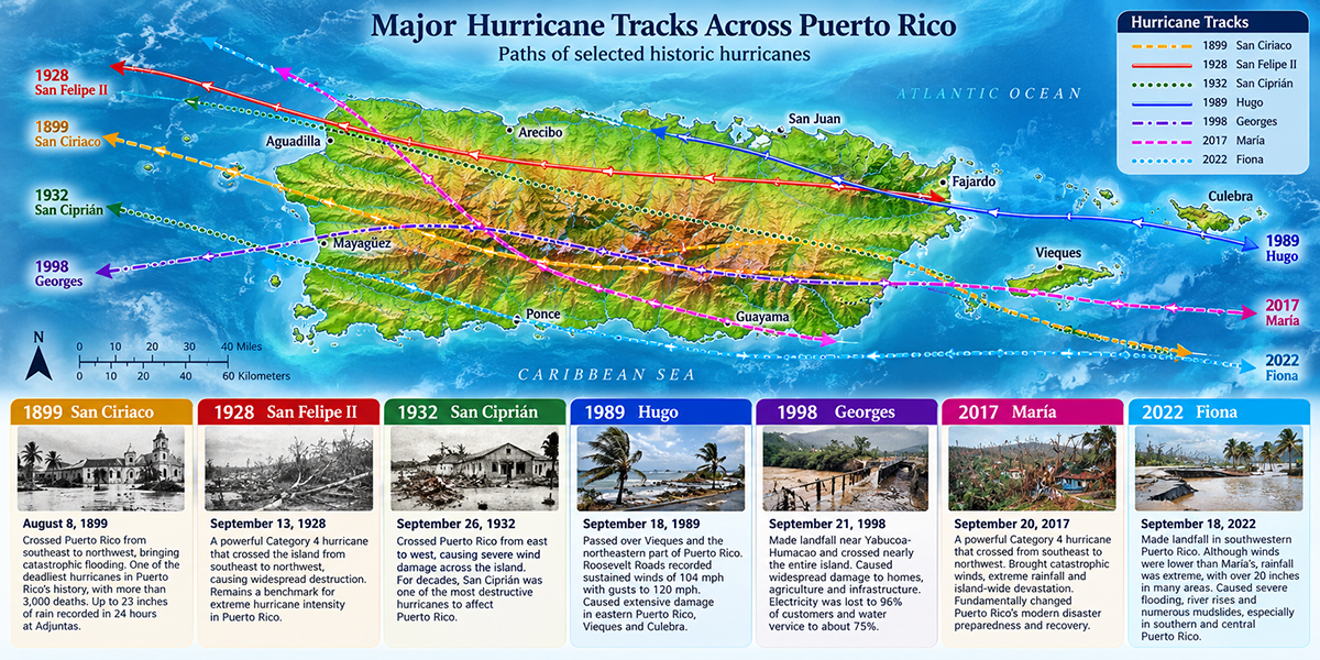
Hurricanes have shaped Puerto Rico's landscape, communities and history for centuries. Before storms received standardized names, Puerto Ricans commonly identified major hurricanes by the Catholic saint's day on which they struck—names such as San Ciriaco, San Felipe and San Ciprián remain part of the island's historical memory.
Some storms are remembered for catastrophic loss of life, others for their winds, flooding or destruction of infrastructure. The hurricanes below are among the most consequential in Puerto Rico's recorded history.
1899 — Hurricane San Ciriaco
San Ciriaco crossed Puerto Rico from southeast to northwest on August 8, 1899, bringing destructive winds and extraordinary rainfall. The center entered near Arroyo and crossed the island before emerging near Aguadilla.
The hurricane caused catastrophic flooding and remains one of the deadliest natural disasters in Puerto Rico's history. NOAA historical records report more than 3,000 deaths, many caused by drowning. At Adjuntas, 23 inches of rain were recorded in 24 hours, a remarkable rainfall total that illustrates the severe flood threat hurricanes can pose to Puerto Rico's mountainous interior.
Why it matters:
One of Puerto Rico's deadliest recorded hurricanes and an early landmark in organized hurricane observation and warning on the island.
1928 — Hurricane San Felipe II
On September 13, 1928, a powerful hurricane known in Puerto Rico as San Felipe II crossed the island. The storm entered southeastern Puerto Rico and traveled northwestward across the island, producing extraordinary winds and widespread destruction.
Contemporary U.S. Weather Bureau records document the severity of the hurricane as it passed Puerto Rico. The name San Felipe II distinguishes it from another hurricane associated with the feast of San Felipe that affected Puerto Rico in 1876.
Why it matters:
It became a benchmark for extreme hurricane intensity in Puerto Rico. When Hurricane María struck in 2017, the National Weather Service noted that Puerto Rico had not experienced a Category 4-or-stronger hurricane since 1928.
1932 — Hurricane San Ciprián
In late September 1932, another destructive hurricane crossed Puerto Rico from east to west. Known locally as San Ciprián, the storm passed through the Virgin Islands before crossing Puerto Rico, producing severe wind damage across the island.
San Ciprián became another historical reference point for island-wide hurricane destruction. More than six decades later, the National Weather Service described Hurricane Georges as the most destructive hurricane to strike the entire island since San Ciprián.
Why it matters:
For generations, San Ciprián remained one of the storms against which later Puerto Rico hurricanes were compared.
1989 — Hurricane Hugo
Hurricane Hugo brought the modern era of major hurricane destruction back to northeastern Puerto Rico. After devastating portions of the northeastern Caribbean, Hugo crossed Vieques and the extreme northeastern part of Puerto Rico in September 1989.
The former Roosevelt Roads Naval Station recorded sustained winds of 104 mph with gusts to 120 mph. Hugo caused extensive damage in eastern Puerto Rico as well as Vieques and Culebra.
Why it matters:
Hugo demonstrated how dramatically hurricane impacts can vary across Puerto Rico: eastern Puerto Rico and the offshore islands experienced some of the storm's most severe effects.
1998 — Hurricane Georges
Hurricane Georges made landfall near Yabucoa-Humacao on September 21, 1998, with sustained winds estimated at 115 mph. Unlike Hugo, which primarily affected eastern Puerto Rico, Georges traveled across nearly the entire island from east to west.
The hurricane caused extensive damage to homes, agriculture and infrastructure. According to the National Weather Service's preliminary report, electricity was lost to 96% of customers, while water and sewer service was lost to approximately 75% of customers. The coffee, plantain and banana crops suffered particularly severe losses.
Why it matters:
Georges was the first hurricane in decades to cross Puerto Rico from one side of the main island to the other, making its effects unusually widespread.
2017 — Hurricane María
Hurricane María made landfall near Yabucoa on the morning of September 20, 2017, as a powerful Category 4 hurricane with maximum sustained winds of approximately 155 mph. It crossed Puerto Rico from southeast to northwest, bringing destructive winds and extreme rainfall across much of the island.
Catastrophic flooding occurred in numerous river basins, communities became isolated when roads and bridges failed, and widespread structural and vegetation damage occurred throughout Puerto Rico. The National Weather Service described catastrophic damage along the path of María's center.
Why it matters:
María fundamentally changed Puerto Rico's modern understanding of hurricane preparedness, infrastructure vulnerability and disaster recovery.
2022 — Hurricane Fiona
Five years after María, Hurricane Fiona made landfall in southwestern Puerto Rico near Punta Tocón on September 18, 2022. Although Fiona's winds were less intense than María's at landfall, rainfall became the dominant hazard.
Parts of Puerto Rico received more than 20 inches of rain, with preliminary estimates exceeding two feet in some areas. Rivers rose rapidly, widespread flooding affected southern and central Puerto Rico, and numerous mudslides occurred in mountainous areas.
Why it matters:
Fiona is a particularly important example of why hurricane categories alone don't describe a storm's danger. Extreme rainfall and flooding can be devastating even when wind speeds are substantially lower than those of a storm such as María.
When a Hurricane Threatens Puerto Rico
If a tropical storm or hurricane threatens Puerto Rico, follow official forecasts and instructions from emergency authorities. Evacuate when directed, avoid flooded roads and waterways, and remain sheltered from high winds in a secure location. Never rely solely on a storm's category or forecast track when deciding whether conditions are dangerous.
Did You Know?
In Puerto Rico, life expectancy at birth for the population has increased from 29.8 years in 1902 to 79.4 years in 2016.
Get Our Newsletter
Discover new places, local flavors, upcoming events, cultural stories, and some of our favorite finds from around the island.Read the Latest ¡La Isla! Newsletter
Follow Along


