
Puerto Rico Highways & Toll Road
Getting Around Puerto Rico
Puerto Rico has an extensive network of highways and local roads connecting its cities, coastal communities, mountains, and popular attractions. While public transportation is available in parts of the San Juan metropolitan area, renting a car is often the most convenient way to explore destinations beyond the capital.
Most major highways are well maintained, but driving conditions can vary significantly between urban expressways, coastal roads, and narrow mountain routes.
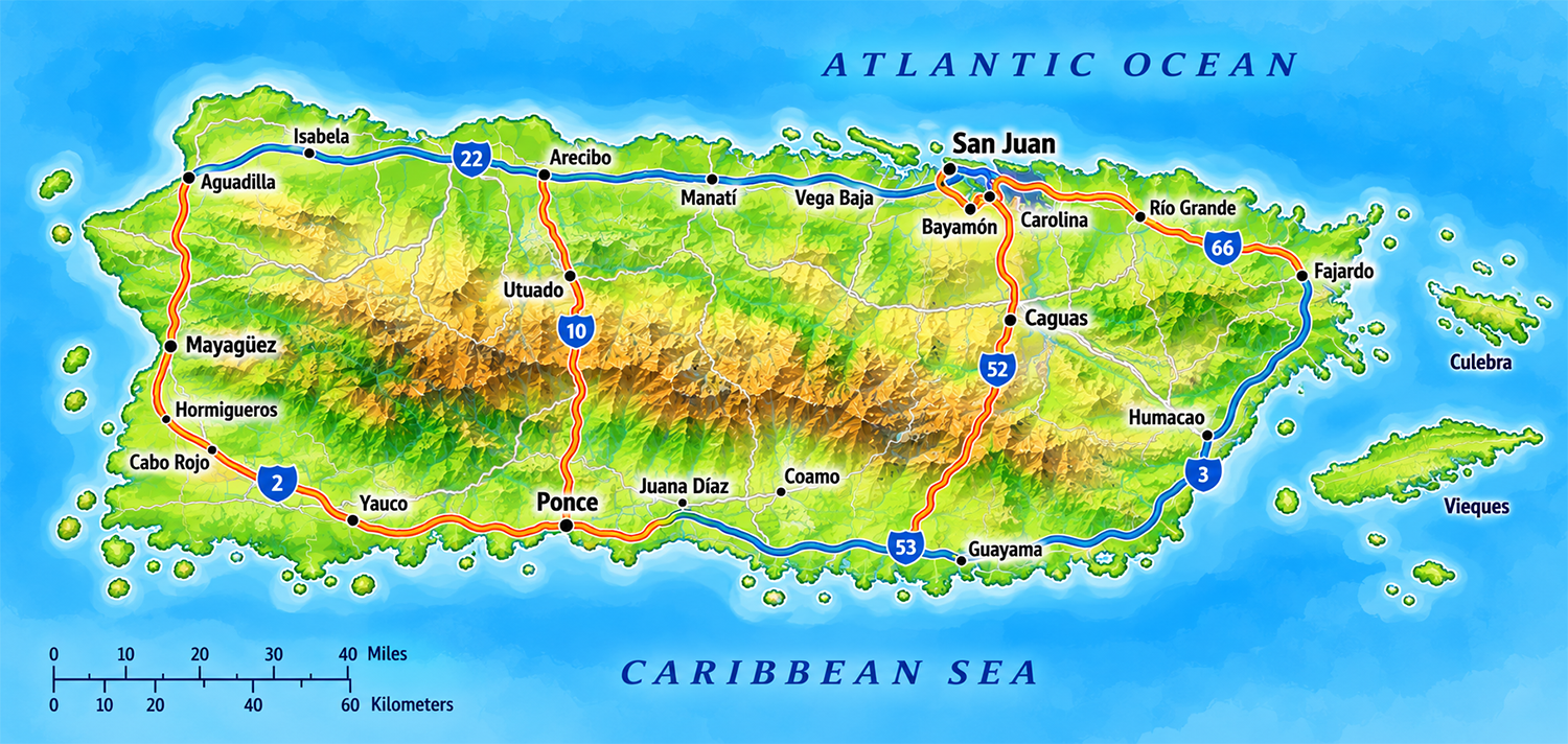
Major Highways in Puerto Rico
Puerto Rico's highway network connects the San Juan metropolitan area with cities, coastal communities, mountain towns, and popular attractions throughout the island. Major routes include toll expressways, primary highways, and scenic roads that provide access to destinations beyond the capital.
The following highways are among the most important routes for residents and visitors traveling across Puerto Rico.
| Highway | Main Route | Description |
|---|---|---|
| PR-1 | San Juan to Ponce | A historic north–south highway passing through communities in Puerto Rico's central interior. It offers an alternative to the faster PR-52 expressway. |
| PR-2 | San Juan to Ponce via western Puerto Rico | One of Puerto Rico's principal highways, connecting northern, western, and southern communities, including Arecibo, Aguadilla, Mayagüez, and Ponce. |
| PR-3 | San Juan to Salinas via eastern Puerto Rico | A major route serving eastern coastal communities, including Carolina, Río Grande, Fajardo, Humacao, and southeastern municipalities. |
| PR-10 | Arecibo to Ponce corridor | A north–south route through Puerto Rico's mountainous interior. It provides access to communities such as Utuado and Adjuntas, although some portions of the corridor require connecting roads. |
| PR-22 | San Juan to Hatillo | Known as Expreso José de Diego, this toll expressway is a major route along the northern coast, connecting the metropolitan area with Bayamón, Arecibo, and other northern communities. |
| PR-52 | San Juan to Ponce | Known as Autopista Luis A. Ferré, this toll expressway is one of the fastest routes between the San Juan metropolitan area and southern Puerto Rico. |
| PR-53 | Eastern and southeastern Puerto Rico | Known as Autopista José Celso Barbosa, this toll expressway serves portions of eastern and southeastern Puerto Rico. The expressway is not continuous along the entire corridor. |
| PR-66 | Carolina to Río Grande | Known as Autopista Roberto Sánchez Vilella, this toll expressway provides an alternative to portions of PR-3 for travel toward northeastern Puerto Rico. |
Understanding Puerto Rico's Highway Numbers
Puerto Rico's numbered roads are organized into several categories. Primary highways generally use one- or two-digit route numbers, while secondary and tertiary roads typically use three- and four-digit numbers.
However, a highway's number does not necessarily indicate whether it is a toll road or a limited-access expressway. Some primary highways pass through towns and intersections, while others include high-speed expressway segments.
Visitors should follow posted road signs and use current navigation information when planning their routes.
Toll Roads in Puerto Rico
Puerto Rico has several toll highways that provide faster connections between major cities and regions. These expressways are particularly useful when traveling between San Juan, the northern coast, southern Puerto Rico, and northeastern destinations.
Toll roads are commonly called autopistas de peaje in Spanish. Most toll facilities use electronic collection systems rather than traditional cash payment booths.
Major Toll Highways
| Highway | Region Served | Toll Information |
|---|---|---|
| PR-22 | Northern Puerto Rico | Toll expressway connecting San Juan with communities along the northern coast toward Hatillo. |
| PR-52 | Central and southern Puerto Rico | Toll expressway connecting the San Juan metropolitan area with Ponce. |
| PR-53 | Eastern and southeastern Puerto Rico | Tolls apply on designated expressway segments serving eastern and southeastern communities. |
| PR-66 | Northeastern Puerto Rico | Toll expressway connecting Carolina with Río Grande. |
Travel tip: Toll charges vary depending on the highway, toll location, and vehicle classification. Check current rates before traveling, particularly if you plan to use toll roads frequently.
AutoExpreso: Puerto Rico's Electronic Toll System
AutoExpreso is Puerto Rico's electronic toll collection system. It allows participating vehicles to pay tolls electronically using an associated account and vehicle identification technology.
Drivers using toll highways should make sure they have an accepted payment arrangement before entering a toll facility.
For account information, participating toll facilities, and current payment instructions, visit the official AutoExpreso website.
How Do Tourists Pay Tolls?
Visitors renting a car should confirm how electronic tolls are handled before leaving the rental counter. Many rental car companies offer toll-payment programs, but the terms and charges can differ.
Depending on the rental company, toll charges may be billed automatically to the rental agreement or processed through a separate toll service.
Before renting a vehicle, ask the following questions:
- Does the rental vehicle include an electronic toll tag or another approved payment method?
- Is enrollment in a toll-payment program automatic or optional?
- Are service fees charged daily, per toll, or only on days when toll roads are used?
- Are toll charges included in the quoted rental price?
- How and when will toll charges appear on the final bill?
Important: Toll charges and rental company service fees are not necessarily the same. A rental company may charge additional administrative fees beyond the toll amount.
Can You Avoid Toll Roads?
Yes. Many destinations in Puerto Rico can be reached using non-toll highways and local roads. However, these alternatives may involve additional intersections, slower traffic, and longer travel times.
Navigation applications often provide an option to avoid toll roads. Review the suggested route before departing, especially when traveling through mountainous areas or unfamiliar communities.
Scenic Drives and Recommended Routes
Driving is one of the best ways to discover Puerto Rico beyond its major tourist destinations. The island's road network offers access to coastal towns, mountain landscapes, historic communities, forests, and scenic viewpoints.
Some routes are best suited for efficient travel, while others offer opportunities to explore the island at a slower pace.
| Route | Highlights | Best For |
|---|---|---|
| PR-2 | Northern and western Puerto Rico, including Aguadilla, Mayagüez, and nearby coastal communities. | Exploring western cities, beaches, and historic towns. |
| PR-3 | Eastern coastal communities, including Río Grande, Fajardo, and Humacao. | Visiting northeastern and eastern destinations. |
| PR-10 | Mountain scenery and communities in Puerto Rico's central interior. | Exploring inland landscapes and mountain towns. |
| PR-22 | Convenient access to northern municipalities, including Arecibo and surrounding communities. | Traveling efficiently along the northern coast. |
| PR-52 | Mountain landscapes along the route between the San Juan metropolitan area and Ponce. | Traveling between northern and southern Puerto Rico. |
| PR-66 | Access to northeastern communities, including Río Grande. | Reaching northeastern attractions while avoiding portions of PR-3. |
La Ruta Panorámica
For travelers interested in a more scenic experience, La Ruta Panorámica is a network of roads crossing Puerto Rico's mountainous interior. The route passes through rural communities, forested landscapes, and areas with impressive views of the island.
Unlike the major expressways, the panoramic route is intended for leisurely exploration rather than fast travel. Sections may include steep grades, sharp curves, narrow lanes, and limited services.
Allow additional travel time, check road conditions, and consider exploring shorter sections rather than attempting the entire route in one day.
Choosing the Right Route
If your priority is reaching a destination quickly, major expressways such as PR-22 and PR-52 may be the most convenient options. If you prefer discovering smaller towns and local attractions, primary highways and scenic roads provide more opportunities to stop along the way.
Travel times can vary significantly depending on traffic, weather, road construction, and the type of road.
Driving Tips for Visitors
Driving in Puerto Rico is generally familiar to visitors from the mainland United States, but several local characteristics are worth understanding before getting behind the wheel.
Driving Rules and Road Signs
- Drive on the right: Vehicles travel on the right side of the road, as in the mainland United States.
- Speed limits: Speed limits are posted in miles per hour (mph).
- Distances: Road distances are generally displayed in kilometers.
- Road signs: Many signs are in Spanish, although familiar traffic symbols are widely used.
- Seat belts: Drivers and passengers must follow Puerto Rico's seat belt and child restraint requirements.
- Driver's license: Visitors with a valid U.S. driver's license can generally drive in Puerto Rico without obtaining an additional local license.
Traffic and Travel Times
Traffic congestion is common in the San Juan metropolitan area, particularly during weekday commuting hours. Major highways such as PR-22 and PR-52 may experience delays near urban centers, interchanges, and toll facilities.
When planning day trips, allow extra time for traffic and avoid scheduling activities too closely together.
Mountain Roads
Roads through Puerto Rico's mountainous interior can be narrow, winding, and steep. Some routes have sharp curves, limited shoulders, and reduced visibility.
Drive cautiously, particularly during heavy rain or after dark. If you are unfamiliar with mountain driving, consider traveling during daylight hours.
Rain and Road Conditions
Tropical rainfall can affect visibility and road conditions. Heavy rain may produce localized flooding, standing water, or landslides, especially in mountainous areas.
During severe weather, avoid flooded roads and follow official travel advisories. Never attempt to drive through moving floodwater.
Navigation and GPS
GPS navigation applications are useful throughout Puerto Rico, but directions are not always perfect. Some smaller roads may be narrow, poorly marked, or unsuitable for certain vehicles.
Review your route before departing and consider downloading offline maps when visiting remote areas where mobile reception may be limited.
Parking
Parking availability varies by destination. Urban areas and popular attractions may have paid parking facilities, while smaller towns often provide street parking or municipal parking areas.
Always observe posted restrictions and avoid leaving valuables visible inside your vehicle.
Local tip: When exploring Puerto Rico's interior, start early in the day. Daylight makes mountain roads easier to navigate and gives you more time to enjoy scenic stops along the way.
Frequently Asked Questions
Are there toll roads in Puerto Rico?
Yes. Puerto Rico has several toll expressways, including PR-22, PR-52, PR-53, and PR-66. These roads provide convenient connections between major cities and regions.
How do tourists pay tolls in Puerto Rico?
Most toll facilities use electronic collection systems such as AutoExpreso. Visitors renting a car should confirm the rental company's toll-payment arrangements and any additional service fees before driving.
Can I drive in Puerto Rico with a U.S. driver's license?
Yes. Visitors with a valid U.S. driver's license can generally drive in Puerto Rico without obtaining an additional local license.
Are Puerto Rico's highways safe to drive?
Major highways are generally suitable for everyday travel, but road conditions, traffic, and visibility vary. Mountain roads may be narrow and winding, and heavy rainfall can create hazardous conditions.
What is the main highway from San Juan to Ponce?
PR-52, also known as Autopista Luis A. Ferré, is the principal expressway connecting the San Juan metropolitan area with Ponce in southern Puerto Rico.
Do rental cars in Puerto Rico include AutoExpreso?
Many rental car companies offer electronic toll-payment arrangements, but policies and fees vary. Ask whether the vehicle is enrolled in a toll program and how toll charges will be billed.
Can I avoid toll roads in Puerto Rico?
Yes. Alternative highways and local roads are available for many destinations. However, avoiding toll roads may increase travel time, particularly during peak traffic hours.
Are road distances in Puerto Rico measured in miles or kilometers?
Road distances are generally measured in kilometers, while speed limits are posted in miles per hour. This combination can be confusing for first-time visitors.
What is the most scenic highway in Puerto Rico?
Puerto Rico offers several scenic driving routes, particularly through its mountainous interior. La Ruta Panorámica is especially popular for its mountain landscapes, rural communities, and scenic viewpoints.
Is it difficult to drive in Puerto Rico?
Driving is generally similar to driving in the mainland United States. However, visitors should be prepared for urban traffic, Spanish-language road signs, winding mountain roads, and occasional differences in local driving conditions.
Continue Exploring Puerto Rico
Transportation in Puerto Rico
Explore your options for getting around Puerto Rico, from rental cars and public transportation to taxis, ferries, and other travel options.
Driving in Puerto Rico
Planning a road trip? Discover essential driving tips, including traffic rules, road signs, parking, and navigating the island safely.
Puerto Rico Geography
Discover Puerto Rico's diverse geography, from the Cordillera Central mountains and lush valleys to coastal plains, rivers, and scenic landscapes.
Did You Know?
El Morro wasn't built overnight. Construction began in 1539 and continued for more than 250 years as the fortress expanded to meet new military threats and advances in warfare.
Get Our Newsletter
Discover new places, local flavors, upcoming events, cultural stories, and some of our favorite finds from around the island.Read the Latest ¡La Isla! Newsletter
Follow Along


