
Cordillera Central
The Mountain Backbone of Puerto Rico
Stretching across the heart of the island, the Cordillera Central is Puerto Rico's largest mountain range and the natural feature that has influenced nearly every aspect of the island's history, climate, economy, and culture. From its peaks originate most of Puerto Rico's rivers, its fertile valleys produce world-renowned coffee, and its forests shelter hundreds of native plant and animal species. While many visitors come to Puerto Rico for its beaches, a journey into the Cordillera Central reveals a completely different side of the island—one filled with winding mountain roads, cool breezes, waterfalls, scenic overlooks, and small towns where traditions have remained largely unchanged for generations.
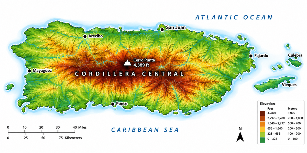
Overview
The Cordillera Central extends approximately 80 miles (130 km) across central Puerto Rico, stretching from Maricao in the west to Cayey in the east. It serves as the island's primary watershed, dividing Puerto Rico into northern and southern regions while creating distinct climates on each side.
Its highest point is Cerro de Punta, rising 4,390 feet (1,338 m) above sea level between the municipalities of Jayuya and Ponce. Numerous state forests, nature reserves, coffee farms, and historic mountain towns are found throughout the range.
How the Cordillera Central Was Formed
The mountains that define Puerto Rico today began forming more than 100 million years ago through intense volcanic activity beneath the ocean. As tectonic plates collided, volcanic islands gradually emerged above sea level. Over millions of years, erosion carved valleys, canyons, rivers, and steep ridges into the landscape, creating the dramatic scenery visitors experience today.
The surrounding limestone formations, particularly in the north, developed later through coral reef deposits that were lifted above sea level, forming the island's famous karst region with caves, sinkholes, and underground rivers.
Why the Cordillera Central Matters
The Cordillera Central is far more than a mountain range—it is the reason Puerto Rico looks, feels, and functions the way it does.
The mountains influence rainfall, determine where rivers flow, create fertile agricultural valleys, moderate temperatures, and separate distinct ecological regions. Historically, they also shaped transportation routes, settlement patterns, and regional traditions.
Without the Cordillera Central, Puerto Rico would not have its lush rainforests, dry southern coast, coffee-growing regions, or hundreds of rivers.
The Mountains Created Puerto Rico's Climate
One of the most fascinating aspects of Puerto Rico's geography is how dramatically the mountains influence the weather.
Moist trade winds blowing from the Atlantic Ocean are forced upward as they encounter the Cordillera Central. As the air rises, it cools and releases moisture as rain over the northern slopes and interior forests.
By the time those air masses descend toward the southern coast, much of their moisture has already fallen, creating a much drier climate.
This phenomenon, known as the rain shadow effect, explains why:
- El Yunque receives over 150 inches of rain annually.
- Ponce is one of Puerto Rico's driest cities.
- Coffee thrives in the mountains.
- Cactus and dry forests flourish in the southwest.
Birthplace of Puerto Rico's Rivers
More than fifty rivers originate within the Cordillera Central, making it the island's principal watershed.
Because Puerto Rico's mountains lie relatively close to both coasts, these rivers tend to be short, fast-flowing, and rich in waterfalls and natural pools.
Some of Puerto Rico's most important rivers include:
- Río de la Plata
- Río Grande de Arecibo
- Río Grande de Loíza
- Río Guanajibo
- Río Culebrinas
- Río Yagüez
These rivers have provided drinking water, irrigation, hydroelectric power, recreation, and transportation for centuries.
Coffee Country
The Cordillera Central is synonymous with Puerto Rican coffee.
Spanish settlers discovered that the cool temperatures, frequent rainfall, fertile volcanic soils, and high elevations created ideal growing conditions for Arabica coffee. During the 19th century, Puerto Rican coffee was considered among the finest in the world and was exported throughout Europe.
Today, visitors can still tour working coffee haciendas, sample locally roasted beans, and learn about traditional cultivation methods.
Well-known coffee-producing municipalities include:
- Adjuntas
- Jayuya
- Maricao
- Lares
- Yauco
- Utuado
Mountain Towns
Each mountain town has developed its own distinct personality.
Adjuntas
Known as the "Switzerland of Puerto Rico," Adjuntas offers cool temperatures, coffee plantations, and scenic overlooks.
Jayuya
The cultural heart of Puerto Rico's Taíno heritage and gateway to Cerro de Punta.
Utuado
Known for caves, rivers, coffee, and outdoor adventure.
Barranquitas
Famous for panoramic mountain views and the birthplace of tenor Antonio Paoli.
Orocovis
Home to Toro Verde Adventure Park and one of the Caribbean's longest zip lines.
Maricao
A quiet mountain municipality known for birdwatching and coffee production.
State Forests
Several of Puerto Rico's most important forests protect the Cordillera Central.
Toro Negro State Forest
Highest forest reserve in Puerto Rico with hiking trails, waterfalls, and Cerro Doña Juana.
Maricao State Forest
One of the island's premier birdwatching destinations and home to extensive coffee-growing regions.
Guilarte State Forest
Offers scenic viewpoints, hiking trails, and camping opportunities.
Carite State Forest
Known for lush vegetation, reservoirs, and abundant birdlife.
Waterfalls and Natural Pools
The mountains are home to many of Puerto Rico's most spectacular waterfalls and swimming holes.
Highlights include:
- Salto La Vaca
- Salto Doña Juana
- Charco Azul
- Salto Curet
- Las Delicias Waterfall
Many require short hikes but reward visitors with unforgettable scenery.
Scenic Mountain Drives
One of the best ways to experience the Cordillera Central is simply by driving through it.
Route 1
San Juan → Cayey → Aibonito → Barranquitas
Rolling mountains, scenic overlooks, bakeries, and roadside fruit stands.
Route 2
Ponce → Adjuntas → Utuado
Coffee country, waterfalls, forests, and mountain vistas.
Route 3
Mayagüez → Maricao → Lares
Coffee plantations, birdwatching, and quiet mountain villages.
Wildlife
The Cordillera Central supports an extraordinary diversity of wildlife.
Visitors may encounter:
- Puerto Rican Tody (San Pedrito)
- Puerto Rican Bullfinch
- Puerto Rican Woodpecker
- Puerto Rican Screech Owl
- Coquí frogs
- Tree ferns
- Native orchids
Several species found here exist nowhere else on Earth.
Mountain Cuisine
The mountains have long been Puerto Rico's agricultural pantry.
Traditional specialties include:
- Freshly roasted Puerto Rican coffee
- Slow-roasted lechón
- Pan sobao from local bakeries
- Longaniza
- Pasteles
- Guineítos
- Yuca
- Sweet plantains
- Mountain cheeses
Roadside restaurants and family-owned bakeries remain an essential part of the experience.
Why I Love La Cordillera Central
Growing up in Puerto Rico, crossing the Cordillera Central always felt like entering another world. The salty sea breeze gave way to cool mountain air, palm trees became forests of giant ferns, and the roads curved through valleys dotted with coffee farms and colorful homes. Every trip included a stop at a neighborhood bakery for warm pan sobao or a roadside restaurant serving fresh lechón. It reminded me that Puerto Rico isn't just beaches—it's an island of remarkable landscapes, where every mountain road reveals another view worth stopping for.
Did You Know?
Because Puerto Rico sits in the tropics, sunrise and sunset vary by less than two hours throughout the entire year. Visitors enjoy roughly 11–13 hours of daylight regardless of the season.
Get Our Newsletter
Discover new places, local flavors, upcoming events, cultural stories, and some of our favorite finds from around the island.Read the Latest ¡La Isla! Newsletter
Follow Along


