
Utuado, Puerto Rico
(oo-too-AH-do)
Utuado is known as "El Pueblo del Viví" (city of the viví). Located deep in Puerto Rico's Cordillera Central, Utuado is a mountain municipality known for its dramatic landscapes, rivers, caves, coffee country, and extraordinary Taíno heritage. Founded in 1739, by Sebastían de Morfi. Utuado takes its name from the Taíno word Otoao, commonly interpreted as "between mountains"—a fitting description for a town surrounded by some of the island's most rugged and beautiful terrain.
Utuado is home to the Caguana Indigenous Ceremonial Park, one of the most important Taíno archaeological sites in the Caribbean. Its ceremonial plazas and petroglyphs offer a remarkable connection to Puerto Rico's Indigenous past, while nearby places such as Cañón Blanco reveal how closely that history is tied to the rivers and mountains of the region.
Overview
Why Visit Utuado?
Utuado offers one of the most immersive ways to experience Puerto Rico's mountainous interior. Surrounded by the Cordillera Central, the municipality combines spectacular scenery, rivers, caves, archaeological sites, coffee country, and small mountain communities far removed from the busier coastal resort areas.
For history and culture, Utuado is especially significant for its Taíno heritage. The Caguana Indigenous Ceremonial Park preserves one of the Caribbean's most important Indigenous ceremonial complexes, while petroglyphs found elsewhere in the municipality reveal how deeply this landscape is connected to Puerto Rico's pre-Columbian past.
Outdoor travelers will find plenty to explore as well. The Tanamá and Caonillas rivers cut through mountains and limestone formations, creating caves, canyons, waterfalls, and natural pools. Lago Dos Bocas and Lago Caonillas add beautiful reservoirs to a landscape ideal for scenic drives, hiking, river adventures, and photography.
Utuado is also part of Puerto Rico's historic coffee-growing region. Its elevation, mountain climate, and agricultural traditions make it a wonderful destination for travelers interested in experiencing the island beyond its beaches and discovering the rural communities, farms, and landscapes of the interior.
Top Things to Do in Utuado
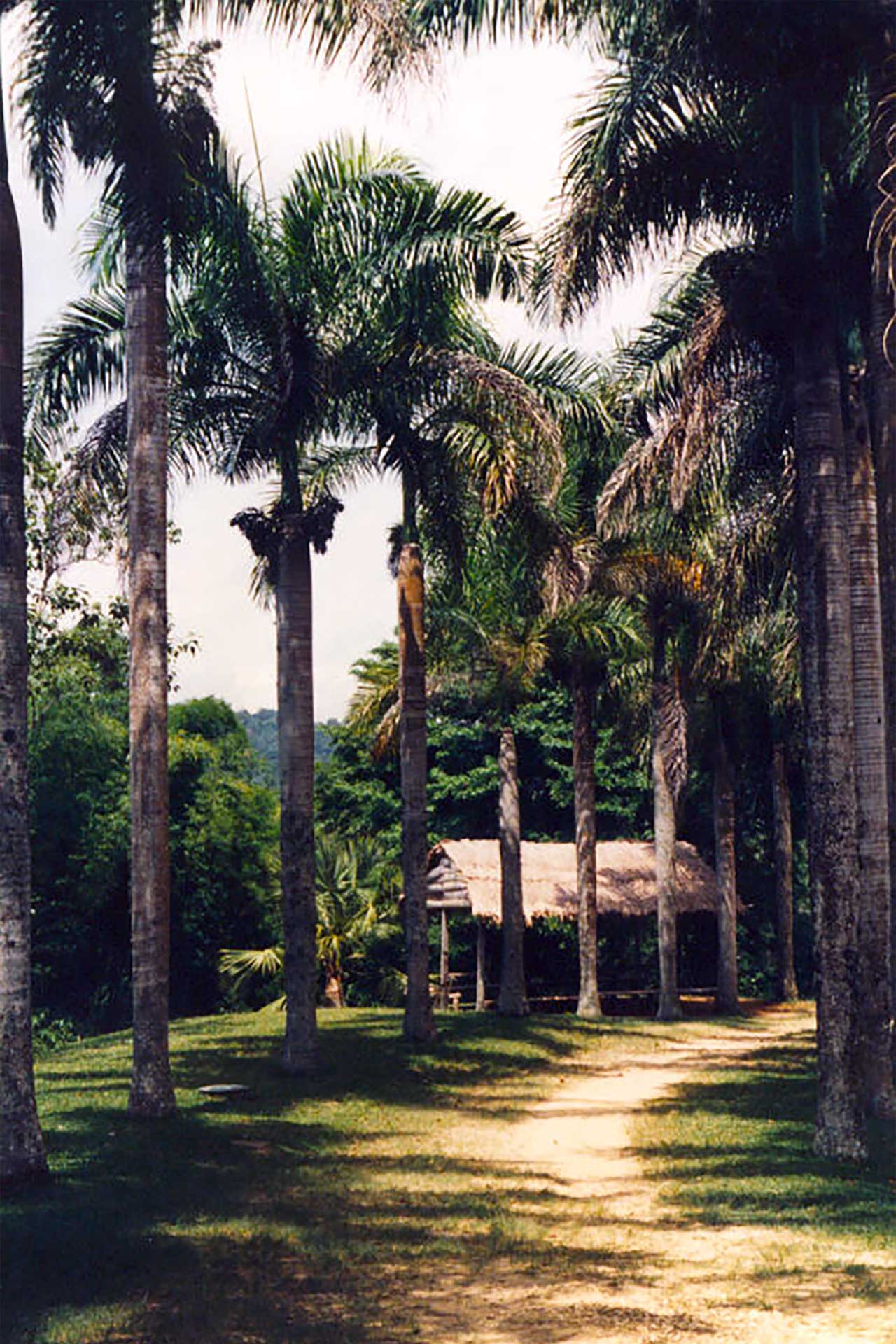
Caguanas, photo by Manuel Santiago
Caguana: A Ceremonial Center in the Mountains
The Caguana Indigenous Ceremonial Park is one of Puerto Rico's most important archaeological sites and one of the most significant Taíno ceremonial complexes in the Caribbean. Located in the Tanamá River Valley, Caguana developed as a major ceremonial center during the centuries before European arrival. Archaeological research dates the principal ceremonial complex to approximately A.D. 1200–1500, with Indigenous occupation continuing into the period of Spanish contact.
The site contains 10 stone-and-earth-lined ceremonial plazas or bateyes, along with carved stone monoliths and numerous petroglyphs. These spaces were much more than playing fields. Bateyes were places where communities could gather for ceremonies, games, dances, storytelling, and other important social and spiritual activities.
The scale of Caguana makes it extraordinary. Its plazas form one of the largest known Indigenous ceremonial complexes of its kind in the West Indies, offering a rare opportunity to walk through a landscape that once served as an important gathering place centuries before the arrival of the Spanish.
More Than a Ball Court
The Taíno batey was an important part of community life. Ceremonial plazas provided spaces for gatherings, games, dances, storytelling, music, and ceremonies. Through these shared traditions, communities reinforced social relationships and passed history, beliefs, and cultural knowledge from one generation to another.
Religion and the natural world were also deeply connected. Taíno spiritual beliefs included zemís — powerful spiritual beings or forces associated with ancestors and elements of the natural world. Images carved into stone and other materials provide some of the most enduring evidence of those beliefs.
At Caguana, petroglyphs carved into the stones surrounding the ceremonial spaces remain among the site's most remarkable features. Their survival allows visitors to encounter Indigenous artistic and spiritual expression in the same mountain landscape where it was created centuries ago.
A Landscape Connected to History
One of the most fascinating aspects of Utuado's Indigenous heritage is that it cannot be separated from the landscape itself. Caguana sits above the Tanamá River in a valley where Puerto Rico's limestone region meets the mountainous volcanic interior. Rivers, caves, valleys, forests, and mountains were part of the environment in which Indigenous communities lived, traveled, farmed, gathered, and practiced their traditions.
That connection extends beyond Caguana. At Cañón Blanco, the Río Caonillas flows through enormous smooth, pale rock formations where Indigenous petroglyphs can still be found. Here, archaeology is not contained within a museum or formal archaeological park — it remains embedded in the landscape.
Seeing these carvings beside a mountain river creates a very different connection to Puerto Rico's Indigenous past. They remind us that the Taíno story is not confined to artifacts behind glass. Evidence of the people who lived here remains written into the mountains and stones themselves.
A Heritage That Endures
Puerto Rico's Indigenous history did not simply disappear when Spanish colonization began. Taíno heritage remains an important part of Puerto Rican culture and identity, visible in archaeological sites and petroglyphs, but also in place names, foods, vocabulary, traditions, and the ways Puerto Ricans continue to understand their relationship with the island.
Utuado offers an especially tangible connection to that history. At Caguana, visitors can walk between ceremonial plazas created centuries ago. Along the Río Caonillas, they can encounter petroglyphs carved into stone. And throughout the municipality, names such as Utuado, Caguana, Caonillas, Tanamá, and Viví preserve echoes of Puerto Rico's Indigenous past.
Together, these places make Utuado much more than a mountain destination. They make it one of the most meaningful places to explore the Indigenous foundations of Puerto Rican history and culture.
Discover Puerto Rico's Indigenous Heritage
Discover Puerto Rico's Taíno heritage through ancient ceremonial plazas, petroglyphs, and sacred sites across the island's mountains and forests.Explore Puerto Rico's Indigenous Heritage
Cañón Blanco
A dramatic mountain canyon where the Río Caonillas flows between smooth white rock formations, creating natural pools and an extraordinary landscape. Indigenous petroglyphs found among the rocks add another layer of cultural significance to the site.
Tanamá River
One of Utuado's great outdoor adventure destinations, with a landscape of forest, caves, limestone formations, waterfalls, and river passages. Guided excursions in the area may include hiking, caving, rappelling, kayaking, and river adventures.
Lago Dos Bocas
A large mountain reservoir surrounded by the lush hills of central Puerto Rico. Its scenic waters and surrounding landscape offer a different perspective on Utuado's mountainous terrain.
Lago Caonillas
A reservoir in Utuado's mountainous interior surrounded by forests and dramatic terrain, adding to the municipality's extensive network of rivers, lakes, and watersheds.
Utuado Pueblo
The historic urban center of the municipality, centered around its traditional plaza, church, municipal buildings, local businesses, and the everyday life of this mountain community.
Plan your Visit
Located in Puerto Rico's mountainous interior, Utuado is best explored by car, allowing visitors to reach its archaeological sites, rivers, lakes, caves, coffee country, and remote mountain communities.
Getting There
By Air
Luis Muñoz Marín International Airport (SJU) is approximately 1½ to 2 hours from Utuado by car, depending on traffic and road conditions. Rafael Hernández Airport (BQN) in Aguadilla is another option for visitors arriving on Puerto Rico's west coast.
By Car
Driving is the most practical way to reach Utuado. Routes into the municipality travel through Puerto Rico's mountainous interior, where roads become increasingly winding as you approach the town and surrounding countryside.
Getting Around
Rental Car
A rental car is strongly recommended for exploring Utuado. Many of its most interesting natural and cultural attractions are spread throughout the mountains and countryside.
Guided Adventures
Local guides and tour operators offer excursions to caves, rivers, canyons, archaeological areas, and other locations that may be difficult to explore independently.
Walking
Utuado's town center can be explored on foot, particularly around the traditional plaza and nearby businesses, but a vehicle is necessary for reaching most attractions outside the urban center.
Nature & Resources
Geography
Utuado is located north of Adjuntas and Ponce; south of Hatillo, Arecibo and Florida; east of Lares; and west of Ciales and Jayuya.
Mountains & Valleys
Utuado lies within Puerto Rico's mountainous interior, where steep ridges, deep valleys, forests, and river corridors dominate the landscape. Its rugged terrain has shaped everything from settlement patterns and agriculture to transportation and recreation.
The municipality's elevation and abundant rainfall create a greener, cooler environment than many of Puerto Rico's coastal communities. Scenic mountain roads provide views across valleys, farms, reservoirs, and densely forested hills.
Rivers & Watersheds
Water is one of the defining features of Utuado. The municipality is crossed by numerous rivers and tributaries, including the Río Grande de Arecibo, Río Tanamá, and Río Caonillas. Over centuries, these waterways have helped carve the valleys, caves, canyons, and limestone formations found throughout the region.
The rivers are also part of Utuado's cultural landscape. Indigenous archaeological sites and petroglyphs found near waterways demonstrate the long relationship between people and the rivers of Puerto Rico's interior.
Lakes & Reservoirs
Lago Dos Bocas and Lago Caonillas are two of the municipality's most prominent reservoirs. Surrounded by mountains and tropical vegetation, they contribute to Utuado's distinctive landscape while forming part of Puerto Rico's important water and hydroelectric infrastructure.
Caves & Karst
Northern Utuado reaches into Puerto Rico's karst region, where water moving through limestone has created caves, underground passages, cliffs, sinkholes, and dramatic rock formations. The Tanamá River area is particularly known for its combination of caves, river passages, and outdoor adventure.
Neighborhoods & Barrios
Utuado is made up of 24 barrios (PDF) (wards/districts):
- Angeles
- Arena
- Caguana
- Caniaco
- Caonillas Abajo
- Caonillas Arriba
- Consejo
- Don Alonso
- Guaonico
- Las Palmas
- Limon
- Mameyes Abajo
- Paso Palmas
- Pueblo
- Río Abajo
- Roncador
- Sabana Grande
- Salto Alto
- Salto Arriba
- Santa Isabel
- Santa Rosa
- Tetuán
- Viví Abajo
- Viví Arriba
Climate
Utuado has a warm tropical climate moderated by its mountainous terrain and elevation. Temperatures are generally warm throughout the year, but evenings and higher elevations can feel noticeably cooler than Puerto Rico's coastal areas.
Rainfall is an important part of Utuado's environment and helps sustain its lush forests, rivers, reservoirs, and agricultural landscapes. Showers and thunderstorms are common, particularly during the wetter months, and conditions can vary considerably between valleys and higher mountain areas.
10 Day Forecast from weather.com
Where to Stay
Staying overnight in Utuado offers a very different experience from Puerto Rico's coastal resort areas. Accommodations here emphasize mountain views, nature, coffee country, and quiet rural settings.
- Casa Grande Mountain Retreat
- La Posada Mountain Retreat
- Finca Remedio
- Monte Sagrado Reserve / Hacienda Horizonte
- Finca Viernes
- Río Abajo Forest Cabin
- Casa Lago
- Lakeview Mountain Guest House
- Finca Regina
Local Flavors & Festivities
Utuado's food reflects its mountain setting and agricultural traditions. Puerto Rican comfort food, locally grown coffee, roadside eateries, and family-run restaurants are part of the experience of traveling through the municipality.
Where to Eat
- La Familia
- Hijos del Josco
- Las Tortugas
- Pueblo Viejo 419 Gastrobar
- Finca Vista Bella
- Bier Garden
- Andares Bistro Café & Pub
- Café Gran Batey
- Café Jumao
Festivals and Events
Displaying 6 results.
-
Fiesta del Barrio Angeles
- March
Community celebration held in Barrio Ángeles featuring local traditions, music, food and activities.
-
Festival Tierra Adentro
- April
Cultural festival celebrating Utuado's mountain heritage, traditional music, artisans, agriculture and Puerto Rican rural traditions.
-
Fiestas de Guarionex
- April
Celebration honoring the Indigenous heritage associated with Utuado and the Taíno cacique Guarionex.
-
Rosario de Cruz
- May
Traditional religious and community observance associated with Puerto Rico's rosario de cruz traditions.
-
Fiestas Patronales de San Miguel Arcangel
- September
Utuado's traditional patron saint celebration honoring San Miguel Arcángel with religious observances, music, food and community festivities.
-
Fiesta Cultural del Otoao
- December
Cultural celebration highlighting Utuado's heritage, traditions and identity, taking its name from Otoao, the Indigenous name associated with the area.
History
Long before the arrival of Europeans, the mountains and river valleys surrounding present-day Utuado were home to thriving Indigenous communities. The area's archaeological legacy is preserved most prominently at the Caguana Indigenous Ceremonial Park, one of the most important Taíno ceremonial sites in the Caribbean.
Caguana contains a remarkable complex of ceremonial plazas, or bateyes, surrounded by stone alignments and petroglyphs. Archaeological evidence demonstrates the site's ceremonial importance and occupation extending into the period of European contact. Today, Caguana provides one of Puerto Rico's strongest physical connections to the island's Indigenous past.
The Spanish settlement of Utuado was officially founded in 1739. Agriculture became central to the municipality's development, particularly coffee cultivation in the surrounding mountains. The steep terrain, fertile valleys, abundant rainfall, and rural communities helped establish the agricultural character that remains visible throughout Utuado today.
During the 20th century, the construction of reservoirs and hydroelectric infrastructure transformed portions of Utuado's landscape. Lago Dos Bocas and Lago Caonillas became prominent features among the mountains, while roads increasingly connected previously isolated communities.
Today, Utuado combines Indigenous heritage, coffee-growing traditions, outdoor recreation, conservation, and mountain life. Its archaeological sites, rivers, forests, farms, and rural landscapes make it one of the best places to experience Puerto Rico beyond the coastal tourism centers.
Moments in History
Indigenous communities establish important settlements and ceremonial spaces in the mountainous region surrounding present-day Utuado.
The ceremonial complex at Caguana develops into one of the most significant Indigenous ceremonial centers in the Antilles, with plazas, stone alignments, and carved petroglyphs.
Utuado is officially founded during the Spanish colonial period.
Coffee cultivation expands throughout Puerto Rico's mountainous interior, becoming an important part of Utuado's agricultural economy and rural identity.
Reservoir and hydroelectric development creates major bodies of water including Lago Dos Bocas and Lago Caonillas, transforming parts of Utuado's mountain landscape.
The Caguana Site is designated a National Historic Landmark, recognizing its exceptional archaeological and cultural importance.
Utuado preserves a distinctive combination of Indigenous heritage, coffee culture, agriculture, forests, rivers, caves, and mountain communities while growing as a destination for cultural and nature-based tourism.
Notable People
Utuado has been the birthplace and home of influential Puerto Ricans in politics, medicine, literature, education, and the arts. Among them are leaders who helped shape Puerto Rico's political institutions, pioneering physicians and researchers, and writers whose works documented the life and social realities of the island's rural communities.
Famous Utuadeños
María Libertad Gómez Garriga
1889–1961
Education • Politics
Educator and political leader who became one of the founders of the Popular Democratic Party. She served in the Puerto Rico House of Representatives, participated in Puerto Rico's Constitutional Convention, and was an important figure in the island's political history.
Isaac González Martínez
1871–1954
Medicine • Science
Physician and researcher recognized as a pioneer in cancer research in Puerto Rico. His medical work contributed to the study of cancer and infectious diseases on the island.
Ramón Juliá Marín
1878–1917
Literature
Puerto Rican novelist, poet, and short-story writer whose works explored rural life and social conditions in Puerto Rico. His best-known novels include La gleba and Tierra adentro.
City Symbols
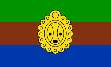
Flag
Utuado's municipal flag incorporates green, brown, and blue, colors associated with the municipality's mountains, land, and waters. At its center appears a representation of the sun associated with Indigenous imagery, reflecting Utuado's strong connection to Puerto Rico's Taíno heritage.
Coat of Arms
Utuado's coat of arms incorporates imagery representing the municipality's Indigenous heritage, agricultural traditions, natural landscape, and history. Its symbolism reflects the mountains and fertile lands that have shaped Utuado's identity for centuries.
Anthem
The anthem celebrates the municipality's mountain landscape and its historical identity, including the Indigenous name Otoao associated with the region.
Valle bendito el de mi Otoao...
Human & Capital Resources
Education
Education in Utuado is primarily provided through schools administered by the Puerto Rico Department of Education, serving students throughout the municipality's urban center and rural mountain communities.
Utuado is also home to the University of Puerto Rico at Utuado, a campus with academic programs closely connected to the needs and traditions of Puerto Rico's central mountain region. Its location in an agricultural municipality has historically made agriculture, natural sciences, business, and related disciplines particularly relevant to the campus and surrounding communities.
Economy
Agriculture has shaped Utuado's economy for generations. Coffee is among the municipality's most recognizable agricultural products, alongside plantains, root crops, fruits, and other crops suited to Puerto Rico's mountainous interior.
Today, Utuado's economy also includes retail, education, government services, small businesses, construction, and tourism. Nature and adventure tourism have become increasingly important as visitors come to explore Caguana, the Tanamá River, Cañón Blanco, Río Abajo State Forest, coffee farms, lakes, caves, and other mountain attractions.
Small farms and locally owned businesses remain important to the municipality's character, helping preserve Utuado's connection to Puerto Rico's agricultural and jíbaro traditions.
Demographics *
Population
28,287
Land Area: 113.53 sq mi
Density: 247 per sq mi
Median Age: 44.4
Sex: 52% female
Economics **
$8,918
Median household income: $15,021
Puerto Rico: $21,058
Persons below poverty line: 54.3%
Housing, families and educational attainment *
Number of households
10,087
Housing units density:
125 (2013)
Persons per household: 2.77
High school grad or higher: 72.4%
Marital status: 40% married
* U.S. Census Bureau 2020 data, unless otherwise noted - Source: Quick Facts Puerto Rico.
** U.S. Census Bureau 2016-2020
Map References
Coordinates: 18.2656° N, 66.7006° W
ZIP Code: 00611, 00641
Driving Distance from San Juan: 71.8 miles
Driving Time: 1 hour, 44 minutes
Frequently Asked Questions
Where is Utuado located?
Utuado is located in Puerto Rico's mountainous interior, within the Cordillera Central. It lies south of Arecibo and between municipalities including Lares, Jayuya, Adjuntas, and Ciales.
What is Utuado known for?
Utuado is known for its Taíno heritage, dramatic mountain scenery, coffee farms, rivers, caves, lakes, and outdoor adventures. Its best-known attractions include the Caguana Indigenous Ceremonial Park, Cañón Blanco, Río Tanamá, Lago Dos Bocas, and Lago Caonillas.
How far is Utuado from San Juan?
Utuado is approximately 1½ to 2 hours from San Juan by car, depending on traffic, weather, road conditions, and your destination within the municipality.
Is Utuado worth visiting?
Yes. Utuado is one of Puerto Rico's best destinations for travelers interested in Taíno history, mountain scenery, coffee culture, rivers, caves, hiking, and outdoor adventure.
What is the Caguana Indigenous Ceremonial Park?
The Caguana Indigenous Ceremonial Park is one of Puerto Rico's most important archaeological sites. It preserves ceremonial plazas or bateyes, stone alignments, petroglyphs, and other archaeological evidence connected to the island's Indigenous history.
What is Cañón Blanco?
Cañón Blanco is a scenic canyon along the Río Caonillas known for its striking pale rock formations, mountain pools, and Indigenous petroglyphs. It is one of Utuado's most distinctive natural and cultural landscapes.
What can you do along the Tanamá River?
The Tanamá River area is known for outdoor adventures that may include hiking, cave exploration, rappelling, river tubing, kayaking, and canyoning. Guided excursions are recommended for many activities.
Can you visit coffee farms in Utuado?
Yes. Utuado is part of Puerto Rico's historic coffee-growing region. Café Gran Batey and other farms in the municipality provide opportunities to experience locally grown Puerto Rican coffee and learn about coffee production.
Do you need a car to visit Utuado?
A car is strongly recommended. Utuado covers a large mountainous area, and many of its archaeological sites, rivers, coffee farms, lakes, and other attractions are located outside the town center.
Where should you stay in Utuado?
Utuado offers mountain retreats, coffee-farm stays, cabins, guesthouses, glamping, and lakefront vacation rentals. Casa Grande Mountain Retreat, Monte Sagrado Reserve, Finca Remedio, and properties near Lago Caonillas and Lago Dos Bocas are among the options.
What is the best time to visit Utuado?
Utuado can be visited year-round, although drier weather is generally more convenient for hiking, river adventures, and other outdoor activities. Because mountain weather can change quickly, visitors should check current conditions before exploring rivers, caves, and canyons.
Did You Know?
The park protects part of Puerto Rico's unique karst landscape, a region characterized by limestone hills, caves, sinkholes, and underground rivers.
Get Our Newsletter
Discover new places, local flavors, upcoming events, cultural stories, and some of our favorite finds from around the island.Read the Latest ¡La Isla! Newsletter
Follow Along


