
Toa Baja, Puerto Rico
(TO-ah BAH-hah)
Toa Baja is known as "La Ciudad Bajo Aguas" (the under water city) is a historic municipality on Puerto Rico's northern coast. Founded in 1745, it developed along the fertile Río de la Plata valley and today combines beaches, historic fortifications, coastal recreation, and neighborhoods closely connected to the San Juan metropolitan area.
The municipality stretches from the Atlantic coast and San Juan Bay inland toward Toa Alta and Bayamón. Its low-lying terrain, fertile plains, and waterways shaped its agricultural past, while its strategic location at the entrance to San Juan Bay made places such as Isla de Cabras and El Cañuelo important to Puerto Rico's colonial defenses.
Overview
Why Visit Toa Baja?
Toa Baja is an easy day trip from San Juan for travelers interested in beaches, colonial history, waterfront scenery, and local culture. Its coastal attractions offer some of the best views back toward Old San Juan and El Morro, while historic sites reveal the municipality's role in defending San Juan Bay and supporting Puerto Rico's early agricultural economy.
The municipality is also a practical stop for families, with swimming areas, picnic facilities, fishing spots, and outdoor recreation close to the metropolitan region.
Top Things to Do in Toa Baja
Isla de Cabras
A scenic coastal recreation area in Palo Seco with sweeping views of Old San Juan, El Morro, and the entrance to San Juan Bay. It is especially popular for photography, picnics, fishing, and sunrise views.
Fortín San Juan de la Cruz (El Cañuelo)
A small Spanish fort strategically positioned across the bay from El Morro. Originally begun in the early 1600s and later rebuilt in masonry, El Cañuelo formed part of the defensive system protecting the entrance to San Juan Bay.
Balneario Punta Salinas
A family-friendly beach with calm waters, picnic facilities, pavilions, fishing areas, and designated zones for kayaking and boating. Its proximity to San Juan makes it a convenient beach option for visitors staying in the metropolitan area.
Hacienda Santa Elena
Founded in 1790 in the Media Luna area, Hacienda Santa Elena became one of Toa Baja's important sugar-producing properties. Its ruins remain part of the municipality's agricultural and industrial heritage.
Central Constancia
A former sugar-processing complex dating to the 19th century whose remaining structures reflect Toa Baja's once-important role in Puerto Rico's sugar economy.
Parroquia San Pedro Apóstol
One of Toa Baja's most important historic landmarks. The parish has deep roots in the colonial settlement of the Río Toa valley and continues to serve as a focal point of religious and community life.
Ermita Nuestra Señora de la Candelaria
A historic chapel associated with the El Plantaje area and an enduring local devotion to Nuestra Señora de la Candelaria. The chapel has been the focus of decades of community preservation efforts.
Guarding San Juan Bay
Toa Baja played an important role in the defense of San Juan Bay during the Spanish colonial period. At the western side of the bay entrance, Fortín San Juan de la Cruz, better known as El Cañuelo, worked together with El Morro across the water to protect the harbor from enemy ships.
Construction of the first fort began in the early 1600s. Its strategic location allowed Spanish forces to create crossfire across the entrance to the bay, while also protecting the waterways that connected the Río Bayamón and interior settlements with San Juan.
Today, visitors to Isla de Cabras can see El Cañuelo and enjoy one of the most dramatic perspectives of Old San Juan and El Morro from across the bay.
Plan your Visit
Located just west of San Juan, Toa Baja is easy to reach by car and is ideal for combining beaches, historic sites, waterfront views, and nearby metropolitan attractions in a single day.
Getting There
By Air
Luis Muñoz Marín International Airport (SJU) is the primary airport serving Toa Baja. Driving time varies by traffic but is generally under one hour.
By Car
Toa Baja is connected to San Juan, Bayamón, Dorado, Toa Alta, and Cataño by major roads and local highways. Driving is the easiest way to reach the municipality's coastal and historic attractions.
Getting Around
Rental Car
A car offers the greatest flexibility for visiting Isla de Cabras, Punta Salinas, Toa Baja Pueblo, Levittown, and historic sites throughout the municipality.
Walking
Individual destinations such as Isla de Cabras, the beach, and the historic town center can be explored on foot once you arrive, but the municipality as a whole is spread out.
Taxis & Rideshare
Rideshare availability is generally better here than in rural municipalities because of Toa Baja's proximity to the San Juan metropolitan area.
Beach & Bay Areas
Weekends can be busier at Punta Salinas and Isla de Cabras, so arriving earlier in the day usually provides easier parking and a more relaxed experience.
Nature & Resources
Geography
Toa Baja lies on Puerto Rico's northern coastal plain, bordered by the Atlantic Ocean to the north, Dorado to the west, Toa Alta to the south, and Cataño and Bayamón to the east. Its terrain is generally low and flat, which helps explain the long-standing nickname Ciudad Bajo Aguas.
The municipality's soils are historically fertile, and the broad alluvial plains surrounding the Río de la Plata supported agriculture and cattle raising for centuries.
Along the coast, Toa Baja includes beaches, mangroves, shallow coastal waters, and the entrance to San Juan Bay, creating a landscape that is both environmentally important and historically strategic.
Rivers & Waterways
The Río de la Plata, historically known as the Río Toa, is the most important river associated with Toa Baja. Its fertile floodplain attracted Indigenous settlement and later Spanish agriculture, helping shape the municipality's early development.
The local hydrological system also includes the Caño Cocal and several smaller streams and drainage channels. Because much of Toa Baja lies on low coastal terrain, water management and flood control have long played important roles in the municipality's development.
Neighborhoods & Barrios
Toa Baja is made up of 9 barrios (PDF) (wards/districts):
- Candelaria
- Campanillas
- Ingenio
- Media Luna
- Levittown
- Pueblo
- Palo Seco
- San José
- Sabana Seca
Climate
Toa Baja has a warm tropical coastal climate, with temperatures remaining relatively consistent throughout the year. Daytime highs commonly reach the mid-to-upper 80s °F (about 29–31°C), while evenings are generally warm and humid.
Rainfall occurs throughout the year, with wetter conditions generally developing from late spring through fall. Because much of Toa Baja sits on low-lying coastal plains near major waterways, heavy rainfall can contribute to localized flooding.
The coastal areas around Punta Salinas, Palo Seco, and Isla de Cabras benefit from Atlantic and bay breezes, which can make conditions feel more comfortable than inland urban areas during the hottest parts of the day.
Visitors should check current weather and marine conditions before beach, boating, or kayaking activities, particularly during the Atlantic hurricane season from June through November.
10 Day Forecast from weather.com
Where to Stay
- Comfort Inn & Suites Levittown
- Aqua by Dreams Hotel & Bar & Grill
- Mango Villas
- Levimar Guest House
- Casa Toñita
- North Breeze Guest House
- Sunset Private Studio
Local Flavors & Festivities
Where to Eat
- La Cabaña
- El Pocito Dulce
- Refresquería Las Tres Palmas
- Harry's Tacos
- Koki Roll
- El Kampestre
- Florpicaleo
- Artesanos del Pan
- Panadería y Repostería Lemy
- Aquino Bakery
- Panadería Los Primos
La Boulevard: Toa Baja's Food Trail
One of Toa Baja's most unexpected attractions is La Boulevard in Levittown, a lively culinary corridor packed with restaurants, food trucks, cafés, bars, bakeries, and casual eateries.
The strip has grown into one of Puerto Rico's notable food destinations, with roughly 60 places offering everything from traditional Puerto Rican cooking and tacos to sushi, brunch, burgers, international cuisine, and creative chef-driven dishes.
Popular stops include Harry's Tacos, known for its Mexican-inspired menu; Koki Roll for Asian flavors; and El Kampestre, where Puerto Rican cuisine draws inspiration from traditional family recipes.
For visitors, La Boulevard offers a completely different side of Toa Baja from Isla de Cabras and Punta Salinas—one centered on neighborhood culture, food, and the energy of Levittown.
Festivals and Events
Displaying 7 results.
-
Festival de Artesanía
- March
Celebration of Puerto Rican craftsmanship featuring artisans, handmade products, cultural displays, music, and community activities.
-
Feria Campo y Pueblo
- May
Family-friendly festival held at Bosque Punta Salinas featuring live music, Puerto Rican culture, entertainment, food, and outdoor activities.
-
Fiestas Patronales de San Pedro Apóstol
- June
Annual patron saint celebration honoring San Pedro Apóstol with religious observances, live music, traditional food, artisans, carnival attractions, and community festivities.
-
Festival Playero
- July
Summer coastal celebration featuring music, food, recreation, and family activities celebrating Toa Baja's beach culture.
-
Fiestas de La Boulevard
- July
Multi-day celebration in Levittown's La Boulevard featuring live music, food, local businesses, artisans, entertainment, and community festivities.
-
Festival de Bandas de Música
- August
Annual music festival featuring bands, musical performances, and community activities celebrating Puerto Rico's musical traditions.
-
Fiestas de Navidad
- December
Christmas-season celebration featuring parrandas, traditional music, holiday activities, food, and community entertainment.
History
Long before the municipality of Toa Baja was established, the fertile valley surrounding the Río Toa was home to Taíno communities. The river, known today as the Río de la Plata, was central to settlement, agriculture, fishing, and transportation throughout the region.
During the earliest years of Spanish colonization, Juan Ponce de León established an agricultural operation along the Río Toa commonly known as the Granja del Rey. Indigenous Taínos were forced to labor there, and European crops were introduced and adapted to local growing conditions.
The exact founding date of Toa Baja has been debated by historians, although 1745 is traditionally recognized as the municipality's founding year. By the eighteenth century, agriculture and cattle raising had become important economic activities along the fertile river plain.
Sugar cane eventually became the dominant crop. Large properties including Hacienda Santa Elena, founded in 1790, and Central Constancia, established near the end of the nineteenth century, helped make Toa Baja an important sugar-producing municipality.
The community also played a strategic role in protecting San Juan Bay. Fortín San Juan de la Cruz, or El Cañuelo, guarded the western side of the harbor entrance and worked together with El Morro across the bay as part of San Juan's colonial defensive system.
During the twentieth century, the decline of agriculture and the rapid growth of the San Juan metropolitan area transformed Toa Baja. Communities such as Levittown expanded, while manufacturing, commerce, construction, services, and residential development became increasingly important.
Moments in History
Juan Ponce de León establishes an agricultural operation along the Río Toa, in a region already inhabited by Taíno communities.
Toa Baja is traditionally recognized as having been founded, although historians differ on the municipality's precise establishment date.
The parish church is established under the patronage of Nuestra Señora de la Concepción, San Pedro and San Matías; today the parish is dedicated to San Pedro Apóstol.
The Ermita de Nuestra Señora de la Candelaria is blessed and opened at Hacienda El Plantaje.
Hacienda Santa Elena is established in Media Luna and becomes one of the municipality's important sugar-producing estates.
Enslaved workers revolt on March 26 and march toward Toa Baja Pueblo, taking control of the Casa del Rey before the uprising is suppressed by Spanish militia.
Central Constancia is founded, becoming another major part of Toa Baja's sugar economy.
Toa Baja is temporarily incorporated into Bayamón under Puerto Rico's municipal consolidation law before being restored as an independent municipality.
Toa Baja adopts its present municipal flag, incorporating symbols of the Río Toa, the fertile plains, and San Pedro Apóstol.
Notable People
Toa Baja has produced poets, writers, educators, scientists, and cultural figures whose accomplishments have contributed to Puerto Rico's literary, academic, and civic life.
Famous Toabajeños
Virgilio Dávila
1869–1943
Poetry • Education
Poet, educator, politician, and businessman born in Toa Baja. His writing celebrated Puerto Rico's landscapes, rural life, and national identity, and he became an important voice in the island's literary tradition.
Ernesto Juan Fonfrías
1909–1990
Literature • Law
Attorney, novelist, poet, essayist, and literary leader who became active in Puerto Rico's cultural and intellectual life and served with the island's PEN organization.
Dr. Carmen A. Pantoja
Astronomy • Science
Astronomer and university professor recognized as the first Puerto Rican woman astronomer. Her academic career has included research, teaching, and scientific outreach in physics and astronomy.
Teresina Delgado
Poetry • Music
Poet, public speaker, and musical composer remembered among Toa Baja's important cultural and literary figures.
Manuel Padilla Dávila
Poetry • Surveying
Surveyor and poet associated with Toa Baja's literary heritage and remembered among the municipality's notable writers.
Luis M. Santiago
Education • Music
Educator and writer associated with Toa Baja who authored the municipality's anthem, preserving local history and pride through music.
City Symbols
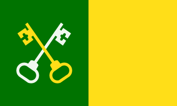
Flag
Adopted in 1980, the flag of Toa Baja uses gold and green. The green band represents the fertile plains of the Toa, while the gold symbolizes the sunlight that shines across the valley. Crossed gold and silver keys represent San Pedro Apóstol, the municipality's patron saint.
Coat of Arms
The coat of arms incorporates a green wavy band representing the historic Río Toa, today known as the Río de la Plata. Crossed keys symbolize San Pedro Apóstol, while crowned Gothic letters "F" and "J" represent Ferdinand II and Juana of Castile and recall the early agricultural settlement known as the Granja de los Reyes Católicos.
Bundles of yuca recognize the crop's importance to Indigenous Taíno communities and the early agricultural settlement, while sugar-cane stalks recall the industry that became one of Toa Baja's principal sources of wealth.
Anthem
Written by Luis M. Santiago, the anthem celebrates the municipality's landscape, history, traditions, and community pride.
Espléndido Toa Baja, jardín de mis amores...
Economy
Agriculture historically formed the foundation of Toa Baja's economy. The fertile alluvial plains surrounding the Río de la Plata supported fruits, livestock, and food crops before sugar cane became the municipality's dominant commercial crop.
By the nineteenth century, large sugar estates and mills employed substantial numbers of workers. Hacienda Santa Elena and Central Constancia became important economic centers, while sugar production continued in Toa Baja well into the twentieth century.
As Puerto Rico industrialized and metropolitan San Juan expanded westward, Toa Baja's economy shifted toward manufacturing, construction, retail, transportation, and services. Metal, plastics, textiles, electronics, concrete products, and beverage production have all formed part of the municipality's modern industrial history.
Today, Toa Baja is closely integrated into the San Juan metropolitan economy. Retail centers, restaurants, professional services, tourism, construction, light industry, and residential development support the local economy, while areas such as La Boulevard have developed into important commercial and culinary destinations.
Education
Public education in Toa Baja is administered primarily by the Puerto Rico Department of Education, with elementary, middle, and secondary schools serving students throughout Pueblo, Levittown, Sabana Seca, Palo Seco, and other communities.
The municipality's location within the San Juan metropolitan region provides residents with convenient access to universities, technical institutes, vocational programs, and other higher-education opportunities in nearby Bayamón, San Juan, and surrounding municipalities.
Toa Baja also has an important connection to science and education through figures such as astronomer Dr. Carmen A. Pantoja, reflecting the municipality's contributions beyond its better-known agricultural and coastal history.
Demographics *
Population
75,293
Land Area: 23.24 sq mi
Density: 3,199.40 per sq mi
Median Age: 42.8
Sex: 55% female
Economics **
$13,510
Median household income: $25,090
Puerto Rico: $21,058
Persons below poverty line: 36.5%
Housing, families and educational attainment *
Number of households
27,915
Housing units density:
1,572.5 (2013)
Persons per household: 2.71
High school grad or higher: 81.4%
Marital status: 35% married
* U.S. Census Bureau 2020 data, unless otherwise noted - Source: Quick Facts Puerto Rico.
** U.S. Census Bureau 2016-2020
Map References
Coordinates: 18.4439° N, 66.2597° W
ZIP Code: 00949, 00950, 00951, 00952
Driving Distance from San Juan: 25.2 miles
Driving Time: 43 minutes
Frequently Asked Questions
What is Toa Baja, Puerto Rico known for?
Toa Baja is known for Isla de Cabras, Fortín El Cañuelo, Punta Salinas, views of Old San Juan, its historic sugar estates, and La Boulevard's popular dining scene.
Where is Toa Baja located?
Toa Baja is located on Puerto Rico's northern coast, west of Cataño and Bayamón, east of Dorado, and north of Toa Alta.
Why is Toa Baja called La Ciudad Bajo Aguas?
The nickname refers to the municipality's low-lying terrain and long history of flooding associated with the Río de la Plata and Puerto Rico's northern coastal plain.
What is Isla de Cabras?
Isla de Cabras is a scenic coastal recreation area in Palo Seco known for views of Old San Juan, El Morro, and the entrance to San Juan Bay. It is also home to historic Fortín El Cañuelo.
What is Fortín El Cañuelo?
Fortín San Juan de la Cruz, commonly called El Cañuelo, is a small Spanish fort built to help defend the western side of the entrance to San Juan Bay in coordination with El Morro.
Does Toa Baja have beaches?
Yes. Balneario Punta Salinas is one of the municipality's most popular coastal recreation areas and offers swimming, picnic facilities, fishing, kayaking, and boating areas.
What is La Boulevard in Toa Baja?
La Boulevard in Levittown is a popular culinary corridor with dozens of restaurants, cafés, food trucks, bars, and other dining options ranging from Puerto Rican cuisine to international flavors.
How far is Toa Baja from San Juan?
Toa Baja is immediately west of the San Juan metropolitan area and can generally be reached within 30 to 45 minutes by car, depending on traffic and the destination within the municipality.
Do I need a car to explore Toa Baja?
A car is recommended for visiting Isla de Cabras, Punta Salinas, Toa Baja Pueblo, Levittown, La Boulevard, and the municipality's historic and coastal attractions.
What are the major festivals in Toa Baja?
Traditional and current celebrations include the Fiestas Patronales de San Pedro Apóstol, Festival de Artesanía, Festival Playero, Festival de Bandas de Música, Feria Campo y Pueblo, Fiestas de La Boulevard, and Christmas festivities.
Did You Know?
Eight major rivers originates in El Yunque and supplies water to 20% of the island's population.
Get Our Newsletter
Discover new places, local flavors, upcoming events, cultural stories, and some of our favorite finds from around the island.Read the Latest ¡La Isla! Newsletter
Follow Along


