Rincon, Puerto Rico
(ring-KON)
Rincón is Puerto Rico's surfing capital, famous for its legendary waves, spectacular sunsets, whale watching, and relaxed beach-town atmosphere. Located on the island's western coast where the Atlantic Ocean meets the Caribbean Sea, west of Añasco and Aguada.
Rincón attracts surfers, divers, beach lovers, and nature enthusiasts from around the world. Beyond its beaches, visitors will discover local art galleries, fresh seafood restaurants, scenic lighthouses, and one of Puerto Rico's most welcoming communities.
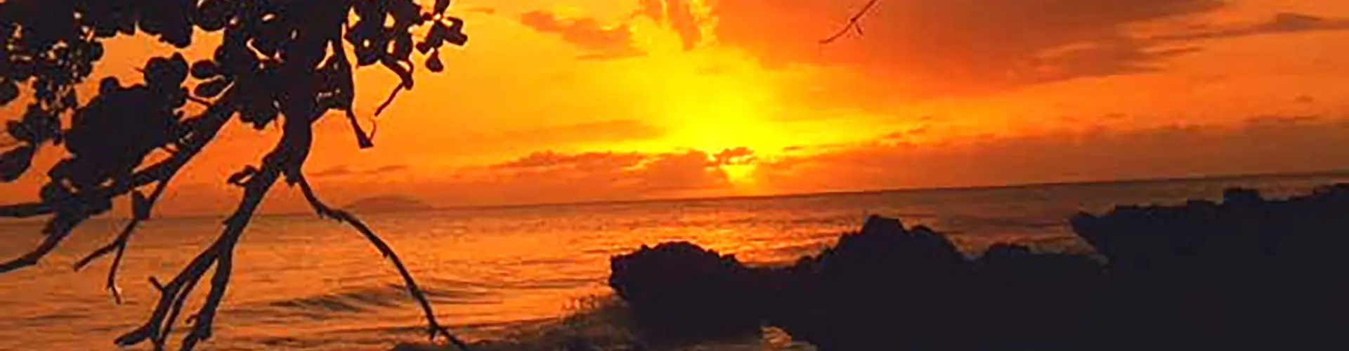
Rincón is known as Pueblo del Surfing (the surfing town) and El Pueblo de los Bellos Atardeceres (the town of beautiful sunsets). Rincón was founded in 1771 by Luis de Añasco.
Overview
Why Visit Rincón?
Rincón is Puerto Rico's surfing capital, celebrated for its legendary waves, spectacular sunsets, and laid-back coastal charm. Whether you're surfing world-class breaks, snorkeling vibrant reefs, watching humpback whales, or simply relaxing on uncrowded beaches, Rincón offers the perfect blend of adventure, natural beauty, and small-town hospitality.
A Different Puerto Rico
Visitors are often surprised by how different Rincón feels from the rest of Puerto Rico. The surf culture, the small-town atmosphere, and the international community create a unique blend of island life that's both welcoming and relaxed. It's one of those places that encourages you to stay just one more day.
Top Attractions in Rincón
The Punta Higuero Lighthouse
Perched atop dramatic limestone cliffs overlooking the Atlantic Ocean, Punta Higuero Lighthouse is one of Rincón's most iconic landmarks. Originally built in 1892 and reconstructed after the 1918 earthquake, the lighthouse continues to guide ships navigating Puerto Rico's western coast.Today, visitors come for much more than history. The surrounding park features walking trails, gardens, scenic overlooks, and some of the island's most spectacular sunsets. During the winter months, the observation deck is also one of Puerto Rico's best places to watch migrating humpback whales as they pass along the western shoreline. watching.
Domes Beach
Located beside Punta Higuero Lighthouse, Domes Beach is one of Puerto Rico's legendary surfing destinations. The beach earned its name from the abandoned nuclear power plant dome visible nearby and has hosted numerous local and international surfing competitions.Powerful winter swells attract experienced surfers from around the world, while calmer summer conditions make the area popular for sightseeing, photography, and relaxing by the ocean. Although swimming is possible during calm weather, visitors should always be mindful of strong currents.
Sandy Beach
Sandy Beach is one of Rincón's most popular gathering places, known for its wide stretch of golden sand, beachfront restaurants, and laid-back atmosphere. It's an excellent destination for sunbathing, beach walks, and enjoying spectacular sunsets over the Caribbean.During the winter surfing season, the beach comes alive with surfers riding the famous waves, while visitors can relax at nearby cafés, browse local shops, or enjoy live music in the evenings.
Steps Beach
Named after the stone steps leading down to the shoreline, Steps Beach is one of Puerto Rico's premier snorkeling and diving destinations. Located within the Tres Palmas Marine Reserve, its crystal-clear waters are home to colorful tropical fish, sea turtles, coral reefs, and other marine life.The calm conditions make it ideal for snorkeling during much of the year, while certified divers can explore deeper reef formations just offshore.
Tres Palmas Marine Reserve
Established to protect one of Puerto Rico's most important coral reef ecosystems, Tres Palmas Marine Reserve is a paradise for snorkelers, divers, and nature lovers. The reserve supports extensive coral formations, sea turtles, tropical fish, rays, and seasonal visits from humpback whales.Visitors are encouraged to practice responsible tourism by avoiding contact with the coral reefs and respecting the protected marine environment.
Rincón Art Walk
Every Thursday evening, downtown Rincón transforms into a lively outdoor marketplace during the popular Art Walk. Local artists, musicians, food vendors, and artisans gather in the town plaza to showcase handcrafted goods, paintings, jewelry, and Puerto Rican cuisine.It's one of the best opportunities to experience Rincón's creative community while enjoying live entertainment and meeting local residents.
Plaza de Recreo
The Plaza de Recreo serves as the heart of downtown Rincón. Surrounded by restaurants, cafés, and historic buildings, the plaza is a welcoming place to relax beneath the shade of mature trees or attend one of the town's many festivals and community events.Like many Puerto Rican town squares, it reflects the island's Spanish colonial heritage while remaining an active gathering place for residents and visitors alike.
Things to do
Whale Watching
From January through March, Rincón becomes one of the Caribbean's premier destinations for humpback whale watching. Thousands of whales migrate from the cold waters of the North Atlantic to the warm Caribbean Sea to mate and give birth.Punta Higuero Lighthouse and nearby observation points offer excellent opportunities to spot whales breaching just offshore, while several local operators offer guided whale-watching excursions.
Surfing in Rincón
Often called the Surfing Capital of the Caribbean, Rincón has been attracting surfers since the 1968 World Surfing Championship introduced the town to an international audience. Today, dozens of surf breaks—including Domes, Maria's, Indicators, and Tres Palmas—offer waves suitable for everyone from beginners to experienced professionals.Surf schools, equipment rentals, and year-round warm waters make Rincón one of the island's best places to learn or improve your surfing skills.
Spectacular Sunsets
Because of its location on Puerto Rico's westernmost coast, Rincón is famous for some of the island's most breathtaking sunsets. Every evening, locals and visitors gather along the beaches, cliffs, and waterfront restaurants to watch the sun disappear below the horizon in a vibrant display of orange, pink, and purple skies.Watching the sunset has become a daily tradition and is considered one of the quintessential Rincón experiences.
Rincón's Surf Legacy
Since hosting the 1968 World Surfing Championship, Rincón has become internationally recognized as Puerto Rico's surfing capital. The event introduced the town to the world and helped establish it as one of the Caribbean's premier surfing destinations. Today, professional surfers, photographers, artists, and ocean enthusiasts from around the globe continue to call Rincón home, contributing to the town's unique blend of Puerto Rican culture and international surf lifestyle.
Moments in History
The area was inhabited by the Taíno people, who relied on fishing, agriculture, and the rich marine resources found along Puerto Rico's western coast.
Rincón is founded as a municipality.
The town was officially established after separating from Aguada, becoming Puerto Rico's 68th municipality. Its name, Rincón ("corner"), reflects its location at the island's northwestern corner.
Fishing and agriculture shape the local economy.
For generations, Rincón remained a small rural community where families depended on fishing, cattle ranching, coconuts, sugar cane, and other agricultural activities.
Punta Higuero Lighthouse is completed.
Built to guide ships navigating the Mona Passage, the lighthouse quickly became one of Puerto Rico's most recognizable coastal landmarks.
Earthquake and tsunami strike Puerto Rico's west coast.
The devastating earthquake damaged Punta Higuero Lighthouse, which was later rebuilt. The event remains one of the most significant natural disasters in Rincón's history.
World Surfing Championship puts Rincón on the map.
The World Surfing Championship introduced Rincón to an international audience. Surfers from around the globe discovered the town's exceptional waves, forever changing its identity and establishing it as Puerto Rico's surfing capital.
Tourism becomes the town's leading industry.
Hotels, guesthouses, restaurants, dive shops, and surf schools flourished as visitors increasingly traveled to Rincón for surfing, snorkeling, scuba diving, whale watching, and spectacular sunsets.
An internationally recognized beach destination.
Today, Rincón is celebrated as one of the Caribbean's premier surfing destinations. While tourism drives much of the local economy, the town continues to preserve its relaxed atmosphere, fishing traditions, natural beauty, and strong sense of community.
Plan your Visit
Whether you are arriving by air at Luis Muñoz Marín International Airport (SJU) or docking at the bustling cruise port, the city serves as the ultimate gateway to the Puerto Rican experience.
Getting There
By Air
Rafael Hernández Airport (BQN) in Aguadilla is the closest airport to Rincón, located about 30 minutes away. The airport offers direct flights from several major U.S. cities and is the most convenient option for visitors staying on Puerto Rico's west coast.
Luis Muñoz Marín International Airport (SJU) in San Juan is Puerto Rico's largest airport and offers the greatest number of domestic and international flights. Rincón is approximately 2½ hours from San Juan by car via PR-22 and PR-2.
Entry Requirements
As a U.S. territory, Puerto Rico requires no passport for U.S. citizens — a government-issued ID suffices. International visitors follow standard U.S. entry requirements.
Getting Around
Rental Car
Rental cars are available at both airports and are the most convenient way to reach Rincón. Private airport transfers and taxis are also available, although rides from San Juan can be expensive due to the distance. If you're staying several days, renting a car is highly recommended.
By Car
Rincón is easily accessible from anywhere on the island via Puerto Rico's highway system. The scenic drive from San Juan takes approximately 2½ hours, while Aguadilla is only about 30 minutes away. Visitors traveling from Ponce can expect a drive of roughly 1½ hours.
Walking
Downtown Rincón is compact and easy to explore on foot. Visitors can walk between the town plaza, local shops, cafés, restaurants, and nearby beaches. Comfortable footwear is recommended, especially when exploring beach trails or walking along uneven sidewalks.
Uber & Taxis
Ride-sharing services are available but are more limited than in the San Juan metropolitan area. Traditional taxis can be arranged through hotels or local transportation providers, but availability may vary, especially during evenings or in less populated areas.
Featured Tours
Neighborhoods & Barrios
Rincón is divided into 10 barrios (PDF) (wards or districts), each offering its own unique character. From lively beachfront communities known for surfing and nightlife to quiet residential and rural areas, the barrios help define the diverse landscapes and experiences found throughout the municipality.
- Atalaya
- Barrero
- Calvache
- Cruces
- Ensenada
- Jagüey
- Bo. Pueblo
- Puntas
- Rincón Pueblo
- Rio Grande
Climate
Rincón enjoys warm tropical weather throughout the year with average temperatures around 80°F (27°C). Cooling trade winds and its location on Puerto Rico's west coast create ideal conditions for surfing, beach activities, and outdoor recreation.
The municipality receives about 53 inches (1,346 mm) of rainfall annually, with October typically being the wettest month and February the driest.
10 Day Forecast from weather.com
Where to Stay
- Horned Dorset Primavera
- Villa Cofresí Hotel
- Rincon Beach Resort
- Tres Sirenas Beach Inn
- Coconut Palms Inn
- Lazy Parrot Inn
- Casa Verde Hotel
- Serenity Rincon Guesthouse
- Rincón Surf Resort Hostel
Whether you're looking for a luxury beachfront resort, a charming boutique hotel, a family-friendly vacation rental, or a surf cottage just steps from the waves, Rincón has accommodations to fit every travel style and budget. Browse our complete guide to places to stay in Rincón.
Where to Eat
- La Cambija
- La Ana de Cofresí
- El Fogón de la Curva
- La Copa Llena
- Casa Isleña
- Tamboo Seaside Grill
- The English Rose
- Jake's Java
- Banana Dang Coffee
- Mi Familias Pizzeria
- Rincón Beer Company
- Ode to the Elephants (Thai)
- Pool Bar Sushi
- Roots Restaurant & Bar
Festivals and Events
Displaying 3 results.
- Festival del Coco - May
-
Fiestas Patronales de Santa Rosa de Lima
- August
Every year, Rincon celebrates a patron saint festival. The festivities include dances, food, parades and religious processions.(787) 823-2575
-
Rincon Art Walk
- Year-round
Weekly evening market featuring local artists, handmade crafts, food vendors, and live music in downtown Rincon.
Notable People
Rincon has shaped artists, athletes, politicians, and visionaries whose influence extends far beyond the island.
Famous Rincoeños
Jaime Sánchez
b. 1938 – d. 2011
Entertainment
One of Puerto Rico's most respected stage and television actors, Jaime Sánchez enjoyed a distinguished career spanning theater, film, and television in both Puerto Rico and the United States
Víctor J. Torres
b. 1947
Politics
A longtime public servant and former member of the Puerto Rico Senate, Víctor J. Torres represented the Mayagüez–Aguadilla District and has been active in public policy and community affairs for decades.
Brunilda Ruiz
b. 1972
Sports
A former Olympic volleyball player, Brunilda Ruiz represented Puerto Rico in international competition and helped elevate women's volleyball on the island through her successful athletic career.
City Symbols

Anthem: Rincón es mi pueblo querido...
Education
There are 8 public schools in Rincon, education is handled by the Puerto Rico Department of Education.
Demographics *
Population
15,187
Land Area: 14.29 sq mi
Density: 969.3 per sq mi
Median Age: 46.9
Sex: 52% female
Economics **
$13,154
Median household income: $20,145
Puerto Rico: $21,058
Persons below poverty line: 43.5%
Housing, families and educational attainment *
Number of households
5,430
Housing units density:
678.4 (2013)
Persons per household: 2.55
High school grad or higher: 71.2%
Marital status: 42% married
* U.S. Census Bureau 2020 data, unless otherwise noted - Source: Quick Facts Puerto Rico.
** U.S. Census Bureau 2016-2020
Map References
Coordinates: 18.3403° N, 67.2517° W
ZIP Code: 677
Driving Distance from San Juan: 96.7 miles
Driving Time: 2 hours, 27 minutes
Frequently Asked Questions
Where is Rincón located?
Rincón is located on Puerto Rico's western coast, about 18 miles (29 km) south of Aguadilla and approximately 2½ hours west of San Juan.
What is Rincón known for?
Rincón is known as Puerto Rico's surfing capital, famous for its world-class waves, spectacular sunsets, beautiful beaches, whale watching, and relaxed beach-town atmosphere.
What are the best beaches in Rincón?
Popular beaches include Domes Beach, Sandy Beach, Steps Beach, María's Beach, and Corcega Beach, offering excellent surfing, snorkeling, swimming, and sunset views.
Why is Rincón famous for surfing?
Rincón gained international recognition after hosting the 1968 World Surfing Championship. Today, its consistent waves attract surfers from around the world throughout the year.
Can you go whale watching in Rincón?
Yes. From January through March, humpback whales migrate along Puerto Rico's west coast, and Punta Higuero Lighthouse is one of the island's best whale-watching locations.
Is Rincón a good place to stay?
Yes. Rincón offers beachfront resorts, boutique hotels, guesthouses, surf cottages, and vacation rentals, making it an excellent base for exploring Puerto Rico's west coast.
Do you need a rental car in Rincón?
Yes. While downtown Rincón is walkable, a rental car is the best way to explore the municipality's beaches, surf breaks, restaurants, and nearby attractions.
How far is Rincón from San Juan?
Rincón is approximately 2½ hours from San Juan by car and about 30 minutes from Rafael Hernández Airport (BQN) in Aguadilla.
When is the best time to visit Rincón?
Rincón is a year-round destination, but December through April offers the driest weather, excellent surfing, and the opportunity to see migrating humpback whales.
What can you do in Rincón besides surfing?
Visitors can enjoy snorkeling, scuba diving, paddleboarding, kayaking, fishing, hiking, beach hopping, shopping, dining, and watching some of Puerto Rico's most spectacular sunsets.
Did You Know?
Cabo Rojo is home to Los Morrillos Lighthouse, one of the most photographed spots on the island.
This is your comprehensive guide to La Isla del Encanto.