
Naguabo, Puerto Rico
(nah-GWAH-bo)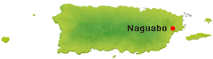
Naguabo is known as "El Pueblo de los Enchumbaos" (the town of the soaked ones), Naguabo is a picturesque coastal municipality on Puerto Rico's eastern shore where mountains, rivers, mangrove forests, and the Caribbean Sea come together. Founded on July 15, 1821, the town offers visitors a unique combination of waterfront dining, outdoor adventures, and authentic Puerto Rican culture. The municipality derives its name from Naguabo, a Taíno chief believed to have lived in the region before Spanish colonization.
Overview
Why Visit Naguabo?
Naguabo combines coastal beauty, lush mountains, fresh seafood, and outdoor adventure, making it one of Puerto Rico's most diverse destinations for nature lovers and food enthusiasts.
Top Things to Do in Naguabo
Malecón de Naguabo
The municipality's lively waterfront featuring seafood restaurants, kiosks, scenic views, and beautiful sunsets over Naguabo Bay.
Reserva Natural Humedal Punta Tuna de Naguabo
Protected wetlands home to mangroves, native birds, and coastal ecosystems.
Playa Húcares
A calm beach and waterfront area popular for swimming, fishing, kayaking, and local seafood restaurants.
Charco El Hippie
A scenic natural swimming hole surrounded by tropical forest and waterfalls near the foothills of El Yunque.
Río Blanco
One of eastern Puerto Rico's beautiful rivers offering freshwater recreation and scenic landscapes.
Plaza Pública de Naguabo
Historic town square surrounded by colorful buildings, cafés, shops, and the parish church.
Iglesia Nuestra Señora del Rosario
Historic Catholic church overlooking the central plaza.
El Yunque National Forest (nearby)
Just a short drive away, offering hiking trails, waterfalls, and rainforest adventures.
Plan your Visit
Located on Puerto Rico's beautiful east coast, Naguabo is best explored by car, offering easy access to beaches, rivers, mountains, and nearby natural attractions.
Getting There
By Air
Luis Muñoz Marín International Airport (SJU) is approximately 1 hour and 15 minutes from Naguabo by car. Antonio Rivera Rodríguez Airport (VQS) on Vieques and José Aponte de la Torre Airport (NRR) in Ceiba are nearby regional airports.
By Car
Naguabo is easily reached via PR-3, PR-31, and PR-53, connecting the municipality with Humacao, Ceiba, Río Grande, and San Juan. A rental car is recommended for exploring the coastline and nearby attractions.
Getting Around
Rental Car
Driving is the most convenient way to explore Naguabo's beaches, waterfront, rivers, mountain roads, and nearby nature reserves.
Malecón & Waterfront
The Malecón de Naguabo is easy to explore on foot, with seafood restaurants, kiosks, fishing piers, and beautiful views of Naguabo Bay all within walking distance.
Taxis & Rideshare
Taxis and rideshare may be available, but service can be limited compared with San Juan.
Nature & Resources
Geography
Naguabo sits between the Sierra de Luquillo foothills and the Caribbean Sea, creating one of Puerto Rico's most diverse landscapes. north of Humacao; south of Río Grande and Ceiba, east of Las Piedras; and El Yunque National Forest to the northwest. Covering approximately 52 square miles (135 km²), the municipality features a diverse landscape of coastal plains, mangrove forests, rivers, mountain foothills, and protected wetlands. Its location between the Sierra de Luquillo and Naguabo Bay makes it one of the island's most scenic municipalities for both mountain and coastal exploration.
Rivers & Natural ResourcesSeveral rivers flow through Naguabo, contributing to its lush tropical landscapes and abundant wildlife. The Río Blanco is the municipality's best-known river, offering scenic swimming holes and freshwater recreation. Other important waterways include the Río Cubuy, Río Icacos, Río Prieto, and numerous smaller streams descending from the Sierra de Luquillo. Along the coast, the municipality protects valuable mangrove forests and wetlands that serve as habitats for migratory birds, fish, and marine life.
Neighborhoods & Barrios
Naguabo is made up of 10 barrios (PDF) (wards/districts):
- Cubuy
- Daguao
- Duque
- Húcares
- Santiago y Lima
- Maizales
- Mariana
- Peña Pobre
- Pueblo
- Río Blanco
Climate
Naguabo enjoys a warm tropical climate year-round, with average temperatures ranging from the upper 70s to mid-80s°F (26–30°C). Its coastal location brings refreshing sea breezes, while nearby mountains receive higher rainfall that supports lush forests, rivers, and abundant wildlife.
10 Day Forecast from weather.com
Where to Stay
- Parador Palmas de Lucía (Yabucoa)
- Wyndham Palmas Beach & Golf Resort (Humacao)
- El Conquistador Resort (Fajardo)
- Parador Palmas de Lucía (Yabucoa)
- Wyndham Palmas Beach & Golf Resort (Humacao)
- El Conquistador Resort (Fajardo)
- Casa Parcha
- Naguabo Ocean View Villa
- El Yunque Retreat Rentals
Local Flavors & Festivities
Where to Eat
- El Mesón de Melquiades
- El Sabor de Naguabo
- La Casa del Chef
- Restaurante El Makito
- La Fanduca
- El Limón
- Panadería Naguabo Bakery
- Café del Malecón
- Panadería La Familia
Festivals and Events
Displaying 5 results.
-
Semana de Pedro Flores
- March
Annual celebration honoring composer Pedro Flores with concerts, cultural programs, and musical performances.(787) 874-3040
-
Festival de Diplo
- June
Festival honoring comedian Ramón Rivero "Diplo" with theatrical performances, comedy, music, and cultural presentations.(787) 874-3040
-
Festival del Chapín
- June
Celebration honoring the municipality's traditional chapín (trunkfish) dish with seafood tastings, live music, artisan vendors, and family activities.(787) 874-3040
-
Fiestas del Carmen
- July
Community celebration featuring live music, artisan vendors, traditional cuisine, and family entertainment.(787) 874-3040
-
Fiestas Patronales Nuestra Señora del Rosario
- October
Naguabo's patron saint festival with religious processions, carnival rides, concerts, artisan vendors, and Puerto Rican food.(787) 874-3040
History
Before Spanish colonization, the region was inhabited by Taíno communities who benefited from the area's fertile valleys, rivers, and abundant coastal resources. According to tradition, the municipality derives its name from Naguabo, a Taíno chief associated with the region.
Naguabo was officially founded on July 15, 1821 by Don Tomás de Abadía. Throughout the nineteenth century, agriculture became the foundation of the local economy, with sugarcane, coconuts, tobacco, and livestock playing important roles. Thanks to its protected bay and strategic location on Puerto Rico's eastern coast, fishing and maritime commerce also contributed to the municipality's growth.
Today, Naguabo is celebrated for its beautiful Malecón, fresh seafood, outdoor recreation, rivers, and easy access to El Yunque National Forest, making it one of eastern Puerto Rico's most scenic destinations.
Moments in History
Taíno communities settled throughout the fertile valleys and coastal areas surrounding present-day Naguabo.
Naguabo is officially founded and established as an independent municipality.
Agriculture, fishing, and maritime commerce become the municipality's principal economic activities.
The Malecón develops into one of eastern Puerto Rico's best-known waterfront destinations for seafood and recreation.
Naguabo continues to attract visitors seeking coastal scenery, outdoor adventures, fresh seafood, and access to nearby El Yunque National Forest.
Notable People
Naguabo has produced influential educators, musicians, entertainers, artists, and public servants whose achievements have enriched Puerto Rico's cultural, political, and artistic heritage.
Famous Naguabeños
Pedro Flores
1894–1979
Music
One of Puerto Rico's greatest composers, Pedro Flores wrote hundreds of boleros and popular songs, including classics such as Obsesión, Amor Perdido, and Esperanza Inútil. His music became internationally recognized throughout Latin America.
Ramón Rivero "Diplo"
1909–1956
Comedy • Theater
A pioneering comedian, actor, producer, and radio personality who became one of Puerto Rico's most beloved entertainers. His satirical humor helped define Puerto Rican comedy during the mid-20th century.
Inés María Mendoza
1908–1990
Education
Educator, writer, and advocate for Spanish-language education who served as Puerto Rico's First Lady alongside Governor Luis Muñoz Marín. She remains one of the island's most respected educational leaders.
Carmen Delia Dipiní
1927–1998
Music
Celebrated singer known as "La Voz de la Ternura," whose recordings of boleros and traditional Puerto Rican music made her one of the island's most admired vocalists.
Arturo Gallardo Woods
1915–2001
Visual Arts
Painter, illustrator, and educator whose work portrayed Puerto Rican landscapes, architecture, and everyday life while mentoring future generations of artists.
Pedro C. Timothee
1940–
Public Service
Public servant and civic leader recognized for his contributions to the development of Naguabo and eastern Puerto Rico through community and governmental service.
City Symbols
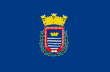
Flag
The flag of Naguabo features a blue field representing the Caribbean Sea and the municipality's coastal heritage. Its central emblem incorporates elements from the municipal coat of arms, symbolizing the town's history, natural resources, and maritime traditions.
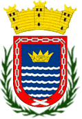
Coat of Arms
The coat of arms depicts blue and silver waves representing Naguabo Bay and the municipality's connection to the sea. The shield also incorporates symbols honoring its Taíno heritage, Spanish colonial history, and agricultural traditions, while the mural crown signifies its status as a municipality.
Anthem
"Hacia el este de las Islas Antillanas" celebrates Naguabo's coastal beauty, proud heritage, hardworking people, and the municipality's enduring connection to Puerto Rico's eastern shoreline.
Hacia el este de las Islas Antillanas...
Human & Capital Resources
Economy
Naguabo's economy has historically been rooted in agriculture and commercial fishing, benefiting from its fertile valleys, abundant rivers, and protected bay. Crops such as plantains, bananas, coconuts, and tropical fruits have long been cultivated throughout the municipality, while seafood harvesting remains an important part of the local identity. Today, tourism, hospitality, retail businesses, healthcare, education, and government services complement the local economy. The Malecón and waterfront restaurants continue to attract visitors from across Puerto Rico, supporting small businesses and the municipality's growing tourism industry.
Education
Education in Naguabo is provided through the Puerto Rico Department of Education, serving students from elementary through high school across the municipality. Residents also have convenient access to nearby higher education institutions, including the University of Puerto Rico at Humacao, Inter American University of Puerto Rico's Fajardo Campus, and Universidad Ana G. Méndez in Gurabo, offering undergraduate and graduate programs across a wide range of disciplines.
Demographics *
Population
23,386
Land Area: 51.66 sq mi
Density: 501.9 per sq mi
Median Age: 39.4
Sex: 53% female
Economics **
$9,337
Median household income: $19,224
Puerto Rico: $21,058
Persons below poverty line: 48.1%
Housing, families and educational attainment *
Number of households
8,276
Housing units density:
232.8 (2013)
Persons per household: 3.13
High school grad or higher: 74.9%
Marital status: 37% married
* U.S. Census Bureau 2020 data, unless otherwise noted - Source: Quick Facts Puerto Rico.
** U.S. Census Bureau 2016-2020
Map References
Coordinates: 18.2194° N, 65.7367° W
ZIP Code: 00718, 00744
Driving Distance from San Juan: 34.9 miles
Driving Time: 1 hour, 19 minutes
Frequently Asked Questions
Where is Naguabo located?
Naguabo is located on Puerto Rico's east coast, bordered by Río Grande, Ceiba, Humacao, and Las Piedras.
What is Naguabo known for?
Naguabo is known for its scenic Malecón, fresh seafood restaurants, rivers, mangrove forests, and easy access to El Yunque National Forest.
Why is Naguabo called "El Pueblo de los Enchumbaos"?
The nickname refers to the municipality's abundance of rainfall and its close relationship with rivers, wetlands, and the surrounding rainforest.
What are the best things to do in Naguabo?
Visitors enjoy the Malecón, Playa Húcares, Charco El Hippie, Río Blanco, kayaking, birdwatching, and exploring nearby El Yunque National Forest.
When are the Fiestas Patronales held?
Naguabo celebrates its Fiestas Patronales in honor of Nuestra Señora del Rosario every October.
What are residents of Naguabo called?
People from Naguabo are known as naguabeños.
Is Naguabo a good destination for seafood?
Yes. The municipality's waterfront is home to several of Puerto Rico's best-known seafood restaurants, serving fresh fish, lobster, shrimp, octopus, and traditional coastal cuisine.
How far is Naguabo from San Juan?
Naguabo is approximately 35 miles (56 km) from San Juan, about a 1 hour and 15 minute drive depending on traffic.
Did You Know?
Jones Act is a federal law requiring that goods shipped between U.S. ports are transported on ships built, owned, and operated by U.S. citizens or permanent residents.
Get Our Newsletter
Discover new places, local flavors, upcoming events, cultural stories, and some of our favorite finds from around the island.Read the Latest ¡La Isla! Newsletter
Follow Along


