
Maunabo, Puerto Rico
(mou-NAH-bo)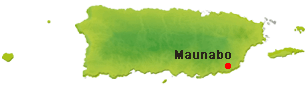
Maunabo is known as "La Ciudad Tranquila" or "La Ciudad de los Jueyeros". Maunabo was founded in 1799. Maunabo derives its name from an Taino Indian river name "Manatabón".
Known as "La Ciudad Tranquila" (The Peaceful City) and "La Ciudad de los Jueyeros" (City of the Crab Catchers), Maunabo is a charming coastal municipality on Puerto Rico's southeastern shore where dramatic mountains meet the Caribbean Sea. Founded in 1799, the town offers visitors a slower pace of life, secluded beaches, rich maritime history, and authentic Puerto Rican culture.
Maunabo is best known for the iconic Punta Tuna Lighthouse, one of Puerto Rico's best-preserved Spanish lighthouses, overlooking rugged coastal cliffs and the Punta Tuna Nature Reserve. The municipality is also home to quiet beaches, scenic coastal drives, the Vicente Morales Lebrón Tunnels, and one of the island's most important wetland ecosystems.
Overview
Why Visit Maunabo?
Maunabo combines scenic beaches, protected natural areas, historic landmarks, and a relaxed small-town atmosphere. Visitors can discover the Punta Tuna Lighthouse, enjoy secluded Caribbean beaches, explore coastal wetlands, experience local seafood traditions, and escape the crowds found in Puerto Rico's more developed resort towns.
Top Things to Do in Maunabo
Faro de Punta Tuna
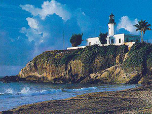
Standing proudly above the southeastern coastline since 1892 (built in 1892 during Spanish rule), the Punta Tuna Lighthouse is one of Puerto Rico's best-preserved Spanish colonial lighthouses. Built to guide ships through the Caribbean Sea and the Vieques Passage, the lighthouse continues to serve as one of the municipality's defining landmarks.
The surrounding park offers sweeping ocean views, dramatic cliffs, walking trails, and excellent birdwatching opportunities. It is also one of the island's favorite sunrise photography locations.
Reserva Natural Humedal Punta Tuna
This protected coastal reserve preserves mangroves, wetlands, beaches, and native wildlife along more than a mile of shoreline. Visitors can enjoy interpretive trails, birdwatching, nature photography, and guided ecotours through one of southeastern Puerto Rico's most important ecosystems.
Playa Larga
A scenic and relatively undeveloped beach known for its wide shoreline, palm-lined surroundings, and peaceful atmosphere. Strong currents can make swimming unsafe, but it is an excellent place for walking, photography, and enjoying the coastal scenery.
Playa Punta Tuna
Located beneath the historic lighthouse, this beautiful beach offers striking views of the cliffs and surrounding coastline. Strong currents make it better suited for sightseeing and beach walks than swimming.
Playa Villa Pesquera
A popular local beach with calmer waters that can be suitable for swimming and kayaking when conditions allow. The nearby fishing community gives visitors a glimpse into Maunabo's traditional coastal lifestyle.
Playa Los Bohíos (Playa Negra)
A quiet coastal gem known for its distinctive dark sand, natural setting, and relaxed atmosphere. It is especially popular with visitors looking for a more secluded beach experience.
Playa California
Known locally for stronger waves, Playa California attracts surfers, bodyboarders, and skimboarders while offering dramatic coastal scenery away from the island's busier resort beaches.
Túneles Vicente Morales Lebrón
Opened in 2008, these twin tunnels pass through the Sierra de Pandura and connect Maunabo with Yabucoa along PR-53. Surrounded by mountains, they have become both an important transportation link and a recognizable landmark of southeastern Puerto Rico.
Ruinas Batey Columbia (La Central)
These historic ruins preserve part of Maunabo's former sugar industry. Established around the beginning of the twentieth century, the site offers a glimpse into the agricultural and industrial history that once shaped the municipality.
Punta Tuna Lighthouse
Built in 1892 during the Spanish colonial era, Punta Tuna Lighthouse is Maunabo's best-known landmark. Perched atop dramatic seaside cliffs overlooking the Caribbean, the historic lighthouse offers panoramic coastal views, scenic walking paths, excellent photography opportunities, and access to the nearby Punta Tuna Nature Reserve. Listed on the National Register of Historic Places, it remains one of Puerto Rico's most iconic lighthouses.
Plan your Visit
Situated on Puerto Rico's scenic southwest coast, Cabo Rojo is best explored by car.
Getting There
By Air
Luis Muñoz Marín International Airport (SJU) is approximately 75 miles (121 km) northwest of Maunabo, about a 1 hour 45 minute drive. José Aponte de la Torre Airport (NRR) in Ceiba is also within driving distance for general aviation.
By Car
Maunabo is accessible via PR-53, PR-901, and PR-760. The Vicente Morales Lebrón Tunnels provide convenient access from Yabucoa, while scenic coastal and mountain roads connect the municipality with Patillas and southeastern Puerto Rico.
Getting Around
Rental Car
A rental car is the easiest and most convenient way to explore Maunabo's beaches, lighthouse, nature reserve, and nearby attractions.
Beach Hopping
Several beaches, including Playa Larga, Playa Punta Tuna, Playa Villa Pesquera, and Playa Los Bohíos, are located just minutes apart, making it easy to enjoy multiple coastal destinations in one day.
Taxis & Rideshare
Taxis and rideshare may be available, but service can be limited compared with San Juan.
Outdoor Adventures
Visitors can explore the Punta Tuna Nature Reserve, enjoy scenic drives through the surrounding mountains, or experience spectacular coastal views from the Punta Tuna Lighthouse.
Nature & Resources
Geography
Maunabo is located on Puerto Rico's southeastern coast, bordered by Yabucoa to the north, Patillas to the west, and the Caribbean Sea to the south. The municipality is framed by the Sierra de Guardarraya and Sierra de Pandura mountain ranges, creating a unique landscape where lush mountains descend to coastal plains, wetlands, and beautiful beaches. Rivers, mangroves, and fertile valleys have long supported agriculture while providing habitat for native wildlife.
Neighborhoods & Barrios
Maunabo is made up of 9 barrios (PDF) (wards/districts):
- Calzada
- Emajagua
- Lizas
- Matuyas Alto
- Matuyas Bajo
- Palo Seco
- Pueblo
- Quebrada Arenas
- Talante
Climate
Maunabo enjoys a warm tropical climate throughout the year, with average temperatures ranging from the mid-70s to upper-80s °F (24–31°C). The nearby Caribbean Sea helps moderate temperatures, while the surrounding mountains create occasional afternoon showers that keep the landscape lush and green. The municipality is an excellent destination for beaches, nature exploration, and outdoor activities during every season.
10 Day Forecast from weather.com
Where to Stay
- Parador MaunaCaribe
- Villas del Faro Resort
- Parador Palmas de Lucía (Yabucoa)
- Wyndham Palmas Beach & Golf Resort (Humacao)
- Four Points by Sheraton Caguas
- Villas del Faro
Local Flavors & Festivities
Where to Eat
- El Muelle Restaurant
- El Puerto Restaurant
- Rincón Criollo/li>
- Aguaviva Restaurant
- Salmorejo Bar & Grill
- MaunaCaribe Restaurant & Bar
- El Puerto Bar & Restaurant
- Bella Vista Restaurant & Sea Terrace
Festivals and Events
Displaying 8 results.
-
Carnaval de Maunabo
- February
Annual carnival featuring colorful parades, vejigante characters, live music, artisan vendors, carnival attractions, traditional food, and community celebrations highlighting Maunabo's cultural traditions.(787) 861-0825
-
Feria de la Caña
- April
Celebrates Maunabo's sugarcane heritage with agricultural exhibits, traditional foods, artisan vendors, cultural demonstrations, live music, and activities highlighting the municipality's historic farming traditions.(787) 861-0825
-
Fiestas Patronales de San Pedro y San Isidro Labrador
- June
Annual patron saint celebration honoring San Pedro and San Isidro Labrador with religious services, processions, live music, traditional Puerto Rican food, carnival rides, artisan vendors, and family entertainment.(787) 861-0825
-
Fiestas de la Virgen del Carmen
- July
Three-day coastal celebration held at Villa Pesquera honoring the Virgen del Carmen with games, tournaments, watersports, live music, food kiosks, and community activities tied to Maunabo's fishing traditions.(787) 861-0825
-
Festi-Carnaval Jueyero
- September
Signature three-day celebration of Maunabo's jueyero tradition featuring crab dishes, live music and DJs, floats, vejigantes, artisan markets, a 5K race, and traditional Puerto Rican food.(787) 861-0825
-
Festival Palo Seco
- November
Community festival celebrating local traditions with music, food, cultural activities, artisan vendors, and family entertainment.(787) 861-0825
-
Festival de Navidad
- December
Holiday celebration featuring Christmas music, parrandas, traditional Puerto Rican foods, artisan vendors, seasonal activities, and family entertainment.(787) 861-0825
-
Maratón Año Viejo
- December
Traditional year-end road race bringing runners and spectators together for an athletic celebration through the streets and communities of Maunabo.(787) 861-0825
History
The area now known as Maunabo was originally inhabited by the Taíno, who called the nearby river Manatuabón, from which the municipality derives its name. Founded on March 9, 1799, Maunabo developed as a small agricultural community producing sugarcane, cattle, fruits, and vegetables. Because the municipality was surrounded by mountains, it remained one of Puerto Rico's most isolated towns for much of its history.
During the nineteenth century, the construction of the Punta Tuna Lighthouse strengthened maritime navigation along Puerto Rico's southeastern coast, while sugar plantations became the area's principal economic activity. The opening of the Vicente Morales Lebrón Tunnels in 2008 dramatically improved access between Maunabo and neighboring municipalities, encouraging tourism and economic development while preserving the town's peaceful character.
Moments in History
Maunabo is officially founded under Spanish colonial rule.
A small port is established, allowing agricultural products to be shipped along Puerto Rico's southeastern coast.
Construction of the Punta Tuna Lighthouse provides safer navigation for vessels traveling the Caribbean coast.
Central Columbia begins operations, helping establish sugar as the municipality's primary industry.
The Vicente Morales Lebrón Tunnels open, dramatically improving transportation between Maunabo and Yabucoa.
Maunabo is recognized for ecotourism, quiet beaches, seafood traditions, and the iconic Punta Tuna Lighthouse.
Notable People
Maunabo has produced educators, artists, public servants, and community leaders whose contributions have helped shape the municipality's cultural and civic legacy.
Famous Maunabeños
Gilberto Martorell
1944–Present
Visual Arts
Puerto Rican artist and printmaker recognized for his contributions to contemporary visual arts and for work inspired by Puerto Rican culture, identity, and social themes.
José G. "Don Gume" Sugrañes
1872–1971
Pharmacy • Public Service
Pharmacist, civic leader, and former mayor of Maunabo whose public service and community involvement made him an important figure in the municipality's early twentieth-century history.
City Symbols
Flag
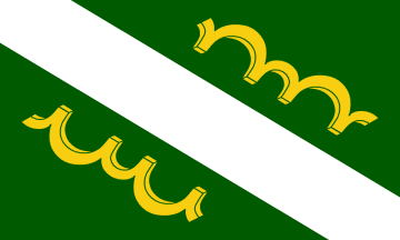
Maunabo's flag features a green field crossed diagonally by a white band. The green represents the municipality's fertile landscape, while the yellow ox yokes symbolize agriculture and honor San Isidro Labrador, the town's patron saint.
Coat of Arms
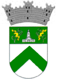
The coat of arms combines green and silver to represent flowering sugarcane, once the municipality's principal crop. A lighthouse symbolizes Punta Tuna, while the inverted green "V" represents the Sierra de Guardarraya and Sierra de Pandura mountain ranges. The ox yokes again recognize Maunabo's agricultural traditions and patron saint.
Anthem
Maunabo pueblito del sureste de mi amada patria Borinquén is the municipality's official anthem. It celebrates Maunabo's beautiful coastline, welcoming community, and pride in its southeastern Puerto Rican heritage.
Maunabo pueblito del sureste de mi amada patria Borinquen...
Human & Capital Resources
Economy
Agriculture has long played an important role in Maunabo's economy, with sugarcane historically serving as the municipality's principal crop. Today, farmers produce fruits, vegetables, and livestock while commercial fishing remains an important local industry. Tourism has become an increasingly important economic driver, with visitors drawn to the Punta Tuna Lighthouse, beaches, wetlands, and ecotourism opportunities. Small businesses, hospitality, retail, and public services also contribute to the local economy.
Education
Education in Maunabo is provided by the Puerto Rico Department of Education through several elementary, middle, and high schools serving the municipality. Students pursuing higher education commonly attend nearby institutions such as the University of Puerto Rico at Humacao (UPRH), Humacao Community College, and the Inter American University of Puerto Rico – Fajardo Campus, all within reasonable driving distance.
Demographics *
Population
10,589
Land Area: 21.07 sq mi
Density: 499.3 per sq mi
Median Age: 44.4
Sex: 51% female
Economics **
$9,872
Median household income: $20,561
Puerto Rico: $21,058
Persons below poverty line: 43.9%
Housing, families and educational attainment *
Number of households
3,893
Housing units density:
263.2 (2013)
Persons per household: 2.71
High school grad or higher: 73.5%
Marital status: 37% married
* U.S. Census Bureau 2020 data, unless otherwise noted - Source: Quick Facts Puerto Rico.
** U.S. Census Bureau 2016-2020
Map References
Coordinates: 18.0072° N, 65.8993° W
ZIP Code: 707
Driving Distance from San Juan: 53.3 miles
Driving Time: 1 hour, 21 minutes
Frequently Asked Questions
Where is Maunabo located?
Maunabo is located on Puerto Rico's southeastern coast, bordered by Yabucoa, Patillas, and the Caribbean Sea.
What is Maunabo known for?
Maunabo is known for the Punta Tuna Lighthouse, quiet beaches, coastal wetlands, scenic mountain roads, seafood traditions, and its relaxed small-town atmosphere.
What are the top attractions in Maunabo?
Popular attractions include Punta Tuna Lighthouse, Punta Tuna Nature Reserve, Playa Larga, Playa Punta Tuna, Playa Villa Pesquera, Playa Los Bohíos, the Vicente Morales Lebrón Tunnels, and the historic Batey Columbia ruins.
Why is Maunabo called "La Ciudad Tranquila"?
The nickname reflects Maunabo's peaceful coastal setting, slower pace of life, and quiet beaches that feel far removed from Puerto Rico's busier tourist areas.
Can you visit Punta Tuna Lighthouse?
Yes. Punta Tuna Lighthouse is one of Maunabo's most important landmarks and can be visited as part of the surrounding coastal and nature reserve area. Access conditions and hours may vary, so visitors should confirm before traveling.
What beaches are in Maunabo?
Popular beaches include Playa Larga, Playa Punta Tuna, Playa Villa Pesquera, Playa Los Bohíos, and Playa California.
What festivals are celebrated in Maunabo?
Major annual events include the Fiestas Patronales de San Pedro y San Isidro Labrador, Festi-Carnaval Jueyero, Feria de la Caña, Fiestas de la Virgen del Carmen, and several sporting and holiday celebrations.
What are people from Maunabo called?
Residents of Maunabo are known as maunabeños and maunabeñas.
What is the best time to visit Maunabo?
Maunabo can be visited year-round, although the drier months from December through April are especially pleasant for beach trips, sightseeing, and outdoor activities.
Is Maunabo worth visiting?
Yes. Maunabo is ideal for travelers who enjoy scenic beaches, historic landmarks, nature reserves, seafood, and a quieter coastal experience away from larger resort areas.
Did You Know?
The Flor de Maga is related to the hibiscus and blooms year-round in Puerto Rico's tropical climate.
Get Our Newsletter
Discover new places, local flavors, upcoming events, cultural stories, and some of our favorite finds from around the island.Read the Latest ¡La Isla! Newsletter
Follow Along


