Caguas, Puerto Rico
(KAH-gwahs)
Caguas is known as "La Ciudad Criolla" (The Creole City), "La Ciudad del Turabo" (Turabo city), and "El Corazón de Borinquén (Borinquen's heart)," Caguas is one of Puerto Rico's cultural and economic centers. Founded on January 1, 1775, the city sits in the fertile Turabo Valley just 30 minutes south of San Juan, where history, art, nature, and modern development come together. Visitors can explore award-winning botanical gardens, museums, lively plazas, performing arts venues, and some of the island's best local restaurants. The city's name honors Caguax, a Taíno chief who converted to Christianity during the early Spanish colonial period, preserving an important piece of Puerto Rico's indigenous heritage.
Overview
Why Visit Caguas?
Caguas blends Puerto Rico's rich cultural heritage with modern city life. Located in the Central Valley just 30 minutes from San Juan, it offers excellent museums, botanical gardens, shopping, local cuisine, and one of the island's most vibrant town plazas. Whether you're interested in history, art, music, or simply enjoying authentic Puerto Rican culture away from the tourist crowds, Caguas makes an ideal day trip or weekend getaway.
Why I Love Caguas?
I've always enjoyed Caguas because it feels like one of those places where Puerto Rico slows down just enough to appreciate everyday life. Sitting in Plaza Santiago R. Palmer watching families gather, visiting the Botanical Garden, or enjoying lunch at a local restaurant reminds me that not every memorable experience happens at the beach. Caguas offers a wonderful balance between city conveniences and Puerto Rico's warm small-town hospitality.
Top Attractions in Caguas

Jardín Botánico y Cultural William Miranda Marín
One of Puerto Rico's finest botanical gardens, featuring tropical plants, reconstructed Taíno and Spanish villages, lakes, sculptures, walking trails, and cultural exhibits spread across more than 60 acres. It's the city's premier attraction and one of the most beautiful parks on the island.Museo de Arte de Caguas
Located in the historic downtown, this museum showcases rotating exhibitions featuring Puerto Rican artists alongside permanent collections celebrating local culture and creativity.
Museo del Tabaco Herminio Torres Grillo
Puerto Rico's only museum dedicated entirely to tobacco tells the story of an industry that shaped the island's economy and culture for centuries. Housed in a beautifully restored 19th-century neoclassical building that once served as a blacksmith shop, the museum explores every stage of tobacco production—from cultivation and curing to cigar rolling and export throughout the Caribbean. Visitors can view historic artifacts, photographs, and a replica of a traditional tobacco drying barn ("ranchón"), while skilled artisans often demonstrate the craft of hand-rolling Puerto Rican cigars. Admission is free, making it one of downtown Caguas' best cultural experiences. Open Tuesday–Saturday, 9:00 a.m.–12:30 p.m. and 1:30 p.m.–5:00 p.m. Admission: Free.
Catedral Dulce Nombre de Jesús
One of Caguas' most recognizable landmarks, this elegant cathedral overlooks Plaza Santiago R. Palmer and has served as the spiritual heart of the city for more than a century.
Plaza Santiago R. Palmer
The city's lively central square is surrounded by restaurants, cafés, historic buildings, and shops. Throughout the year it hosts concerts, artisan fairs, Christmas celebrations, and community festivals.
Centro de Bellas Artes de Caguas
A modern performing arts center featuring concerts, theater productions, dance performances, comedy shows, and cultural events year-round.
Las Catalinas Mall One of Puerto Rico's largest shopping centers outside the Metro Region, offering department stores, boutiques, restaurants, entertainment, and a movie theater.
Caguas is home to several museums. The Museo de Historia de Caguas has five exhibits that showcases the history of Caguas, from the indigenous people up to the present day. The museum's collection includes ceramic, stone artifacts, utensils, bone remains, and skeletal remains. Open Tue-Sat, 9am - 12pm and 1pm - 5pm, 787-653-8833. The Museo de Artes Populares de Caguas showcases arts and crafts from Puerto Rican artisans. Open Wed-Sun 9am-12pm and 1pm-5pm, (787) 744-8833.
Casita Verde Abelardo Díaz Alfaro
The museum celebrates Puerto Rican literature through the famous author Abelardo Diaz Alfaro. Located in a 19th century mansion, the rooms of this museum are decorated with period furniture. Open Tue-Sat 9am - 5pm, 12 Alejandro Ramirez St, (787) 286-7640.
Jorge Sotomayor del Toro Protected Natural Area
Hidden on the slopes of Cerro La Santa, this protected forest preserve safeguards the headwaters of the Turabo River and forms part of the ecological corridor connecting Caguas with Carite State Forest. Rich in native flora and wildlife, the 63-acre reserve is an important conservation area managed by Para la Naturaleza. While public access is limited, nature enthusiasts can occasionally visit through guided educational programs and special conservation events. It is adjacent to the Carite State Forest in the neighboring city of Guayama.
Plan your Visit
Everything you need to know to enjoy Caguas—from arriving in the city and getting around to discovering its museums, restaurants, and local traditions.
Getting There
By Air
Luis Muñoz Marín International Airport (SJU) is approximately 30–35 minutes from Caguas via PR-52. Visitors arriving through Mercedita Airport (PSE) in Ponce can reach Caguas in about 1 hour.
By Car
Caguas is easily accessible via PR-52, Puerto Rico's main north-south expressway. The city also connects to the eastern municipalities via PR-30 and to the mountain towns through PR-1 and PR-156.
Publish Transportation
Intercity buses connect Caguas with San Juan and neighboring municipalities, although service is more limited than driving. Rental cars provide the greatest flexibility for exploring nearby attractions.
Getting Around
Rental Car
The easiest way to experience Caguas and nearby attractions, including the Botanical Garden and surrounding mountain communities.
Walking
Historic downtown Caguas is pedestrian-friendly, making it easy to explore museums, Plaza Santiago R. Palmer, restaurants, cafés, and local shops on foot.
Taxis & Rideshare
Uber and local taxi services are available throughout much of the city, particularly around downtown, shopping centers, and hotels.
Local Tip
Visit Guavate on weekends for the full experience with live music and bustling lechoneras, but arrive early to avoid crowds.
Nature & Resources
Geography
Caguas is located in Puerto Rico's Central Region, approximately 20 miles (32 km) south of San Juan. The municipality borders Trujillo Alto to the north; Gurabo and San Lorenzo to the east; Aguas Buenas, Cidra, and Cayey to the west; and Patillas to the south through its mountainous terrain.
Covering approximately 58 square miles (151 km²), Caguas combines a vibrant urban center with rolling hills, fertile valleys, and rural communities. Several rivers flow through the municipality, including the Río Grande de Loíza, Río Turabo, Río Cañas, Río Bairoa, Río Cagüitas, and Río Cañaboncito, contributing to the area's rich agricultural history.
Neighborhoods & Barrios
Caguas consists of 11 barrios plus the downtown Pueblo district:
- Bairoa
- Beatriz
- Borinquen
- Cañabón
- Cañaboncito
- Pueblo
- Río
- Cañas
- San Antonio
- San Salvador
- Tomás de Castro
- Turabo
Climate
Annual precipitation is approximately 69 inches and the average temperature is 77 F. The driest month is March. The greatest amount of precipitation occurs in September.
10 Day Forecast from weather.com
Where to Stay
- Four Points by Sheraton Caguas Real Hotel & Casino
- Hotel Nest
- Hyatt Place San Juan (about 30 minutes away for visitors exploring both regions)
- The Village Inn
Vacation rentals provide additional space for families and travelers wanting to experience local neighborhoods.
Local Flavors & Festivities
Where to Eat
- El Manjar Criollo
- La Casona de Caguas
- El Novillo Alegre
- Rancho de Apa
- Il Nuovo Mercato
- Romano's Macaroni Grill
- Sizzler
- Osaka Japanese Restaurant
- Gustos Coffee Co.
- Panadería La Española
- Starbucks Reserve
Festivals and Events
- Festival Folklorico - July
-
Fiestas Patronales de Nuestra Sra. del Carmen
- July
Every year, Caguas celebrates a patron saint festival. The festivities include dances, food, parades and religious processions.(787) 746-6100
Displaying 2 results.
Moments in History
Long before the arrival of the Spanish, the valley was home to the Taíno chief Caguax, whose name eventually became Caguas. The region was known for its fertile lands and abundant rivers.
On January 1, 1775, Caguas was officially founded as San Sebastián del Piñal de Caguas, becoming an important agricultural settlement in Puerto Rico's interior.
During the 19th century, Caguas developed into one of Puerto Rico's leading producers of sugar cane, coffee, and tobacco. The municipality prospered through agriculture and trade.
Writer Abelardo Díaz Alfaro, one of Puerto Rico's most beloved storytellers, was born in Caguas. His works helped preserve the island's rural traditions and folklore for future generations.
As Puerto Rico modernized, Caguas gradually transitioned from an agricultural economy to manufacturing, attracting textile factories and later pharmaceutical and medical device companies.
The municipality invested heavily in restoring its historic center, museums, plazas, and cultural institutions, helping transform Caguas into one of Puerto Rico's leading cultural destinations.
Known as "La Ciudad Criolla" (The Creole City), Caguas blends history, art, nature, and innovation. It is one of Puerto Rico's largest municipalities and serves as an important commercial, educational, and healthcare hub for the Central Region.
Notable People
Caguas has produced influential leaders, athletes, artists, and writers whose achievements have helped shape Puerto Rico's culture, politics, and international reputation. From Hall of Fame baseball players to visionary civic leaders, these Cagüeños continue to inspire future generations.
Famous Cagüeños
Abelardo Díaz Alfaro
1916–1999
Author • Educator • Public Servant
Born in Caguas, Abelardo Díaz Alfaro is regarded as one of Puerto Rico's most influential writers. His acclaimed collection of short stories, Terrazo (1947), portrayed the traditions, struggles, humor, and dignity of Puerto Rico's rural communities. His work remains required reading in many Puerto Rican schools and is celebrated for preserving the island's cultural identity and folklore.
William Miranda Marín
1940–2010
Politics & Public Service
Longtime mayor credited with transforming Caguas into one of Puerto Rico's most innovative municipalities through urban revitalization, technology initiatives, cultural investment, and public spaces. The city's Botanical and Cultural Garden proudly bears his name.
José Garriga Picó
1948–Present
History & Literature
Historian, educator, and author recognized for preserving and documenting Puerto Rico's history through numerous books and academic publications.
Read more about famous Caguenos
City Symbols
Caguas' official symbols reflect the municipality's rich Taíno heritage, Spanish colonial roots, and proud cultural identity. The city's flag, coat of arms, and anthem celebrate its history, traditions, and enduring nickname as "La Ciudad Criolla."
Flag
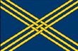
The flag of Caguas features a deep blue field crossed by intertwined golden diagonal bands that form a distinctive lattice pattern. The design is inspired by the coat of arms and symbolizes the municipality's unity, history, and agricultural heritage. The blue represents loyalty and justice, while the gold reflects prosperity, generosity, and the city's cultural richness.

Coat of Arms
The coat of arms of Caguas is rich in symbolism. At its center are crossed sugar cane stalks, representing the municipality's agricultural roots and the importance of sugar production to its early economy. Above them is a royal crown, recalling the city's Spanish colonial heritage and its original name, San Sebastián del Piñal de Caguas.
Surrounding the sugar cane are golden pineapples, symbols of hospitality, abundance, and the fertile lands of the Turabo Valley. The mural crown at the top signifies Caguas' status as an important municipality within Puerto Rico.
Anthem
The municipal anthem of Caguas is a tribute to "La Ciudad Criolla", celebrating the municipality's rich history, cultural traditions, and the hardworking spirit of its people. The lyrics honor Caguas' agricultural roots, its growth into one of Puerto Rico's leading commercial and cultural centers, and the pride residents have in their hometown.
Performed during civic ceremonies, municipal events, and the Fiestas Patronales de Nuestra Señora del Carmen, the anthem reflects the community's strong identity and its enduring connection to the Turabo Valley. It serves as a musical expression of the city's heritage and the affection generations of Cagüeños feel for their beloved municipality.
Human & Capital Resources
Economy
The town's economic activities include: diamond cutting, tobacco processing, and the manufacture of leather goods, glass and plastic products, electronic equipment, clothing and bedding.
Education
There are 52 public schools in Caguas, education is handled by the Puerto Rico Department of Education. Caguas is also home of 13 colleges and universities.
Demographics *
Population
127,244
Land Area: 58.6 sq mi
Density: 2,162.90 per sq mi
Median Age: 44.2
Sex: 54% female
Economics **
$15,757
Median household income: $25,823
Puerto Rico: $21,058
Persons below poverty line: 37.1%
Housing, families and educational attainment *
Number of households
48,446
Housing units density:
1,030.2 (2013)
Persons per household: 2.59
High school grad or higher: 82.6%
Marital status: 32% married
* U.S. Census Bureau 2020 data, unless otherwise noted - Source: Quick Facts Puerto Rico.
** U.S. Census Bureau 2016-2020
Map References
Coordinates: 18.2314° N, 66.0394° W
ZIP Code: 00725, 00726, 00727
Driving Distance from San Juan: 23.7 miles
Driving Time: 42 minutes
Did You Know?
Juan Mari Bras is the world's only Puerto Rican citizen.
This is your comprehensive guide to La Isla del Encanto.