Añasco, Puerto Rico
(ah-NYAHS-ko)
Añasco is known as "La Ciudad Donde los Dioses Mueren" (the city where the gods die) and "El Pueblo Del Hojaldre". The town was founded in October 18, 1733 by Luis de Añasco, a colonist from the Extremadura region of Spain who came to Puerto Rico with Juan Ponce de Añasco. Subsequently, the city was named after him.
The Parroquia San Antonio Abad was founded in 1728, the original church was replaced by the current structure in 1801. This new church has a beautiful 8-foot stained glass window above the front door. The bell tower includes 800 and 500-pound bells along with a number of smaller bells from the original church (tel. 787-826-2215).
The Parque de Diversiones El Castillo amusement park features the largest wave pool in the Caribbean, a medieval castle, antique museum, and haunted house. Open on Wed-Sun & Holidays 10am-6pm (tel. 787-826-0866).
El Mirador de la Bahia is 3-story lookout tower on a small cliff overlooking the Anasco Bay.
Economy
The surrounding areas produces sugar and fruits. Añasco has been long known for producing the best moonshine rum in Puerto Rico.
Geography
Añasco is located in Costal Valley of the West region, bordering the Mona Passage to the west, north of Mayagüez and Las Marías; south of Rincón, Aguada and Moca; and west of San Sebastián and Las Marías.
Añasco is made up of 21 barrios (wards/districts):
- Añasco
- Añasco Abajo
- Añasco Arriba
- Caguabo
- Casey Arriba
- Caracol
- Carreras
- Cerro Gordo
- Cidra
- Corcóvada
- Daguey
- Espino
- Hatillo
- Humatos
- Marías
- Ovejas
- Piñales
- Playa
- Pueblo
- Quebrada Larga
- Río Abajo
Añasco highest peaks include Canta Gallo (370 m), Gordo (340 m) and Pichón (340 m). Its rivers include Río Grande de Añasco (originates in Lares), Huamtas, Casey, La Balase and La Mona.
Climate
Anasco enjoys year-round summer temperatures, an average annual temperature of 77°F. On average, the warmest month is August, and the coolest month is February. Añasco annual precipitation is 13.81 inches. September is the average wettest month.
ANASCO WEATHERNotable People
There are many well-known "añasqueños", among them:
- Mariana Bracetti, patriot and leader of the Puerto Rico independence movement in the 1860's
- José de Jesús Domínguez, poet
- Víctor Arrillaga, poet
- Lolita Aspiros, pianist
Accommodations
- Villas del Castillo Hotel (Hotel),
(787) 826-6088
- Almirante Beach Apartment Rental (Rental),
(787) 464-1823
- Roberto's Hidden Paradise (Rental),
706-868-1942
Restaurants
- Capriccio (Italian), (787) 826-3387
- Chatisy Restaurant (American), (787) 826-2449
- El Tesoro de Julian (American), (787) 826-8025
- Rafael (Sea Food), (787) 826-5023
- Restaurante Casa Linda (Puerto Rican), (787) 868-4228
- Restaurante Chino Wahlon (Chinese), (787) 826-4011
- Restaurante El Coche (Puerto Rican), (787) 826-5151
Festivals and Events
- Festival de Bellas Artes - January
- Festival del Chipe - September
- Festival del Teatro - May
- Festival Mayuco - January
- Festival Santa Rosa de Lima - August
- Fiestas Patronales de San Antonio Abad - January
Every year, Anasco celebrates a patron saint festival. The festivities include dances, food, parades and religious processions. (787) 826-3100 - Maraton Cooperativa - October
Symbols
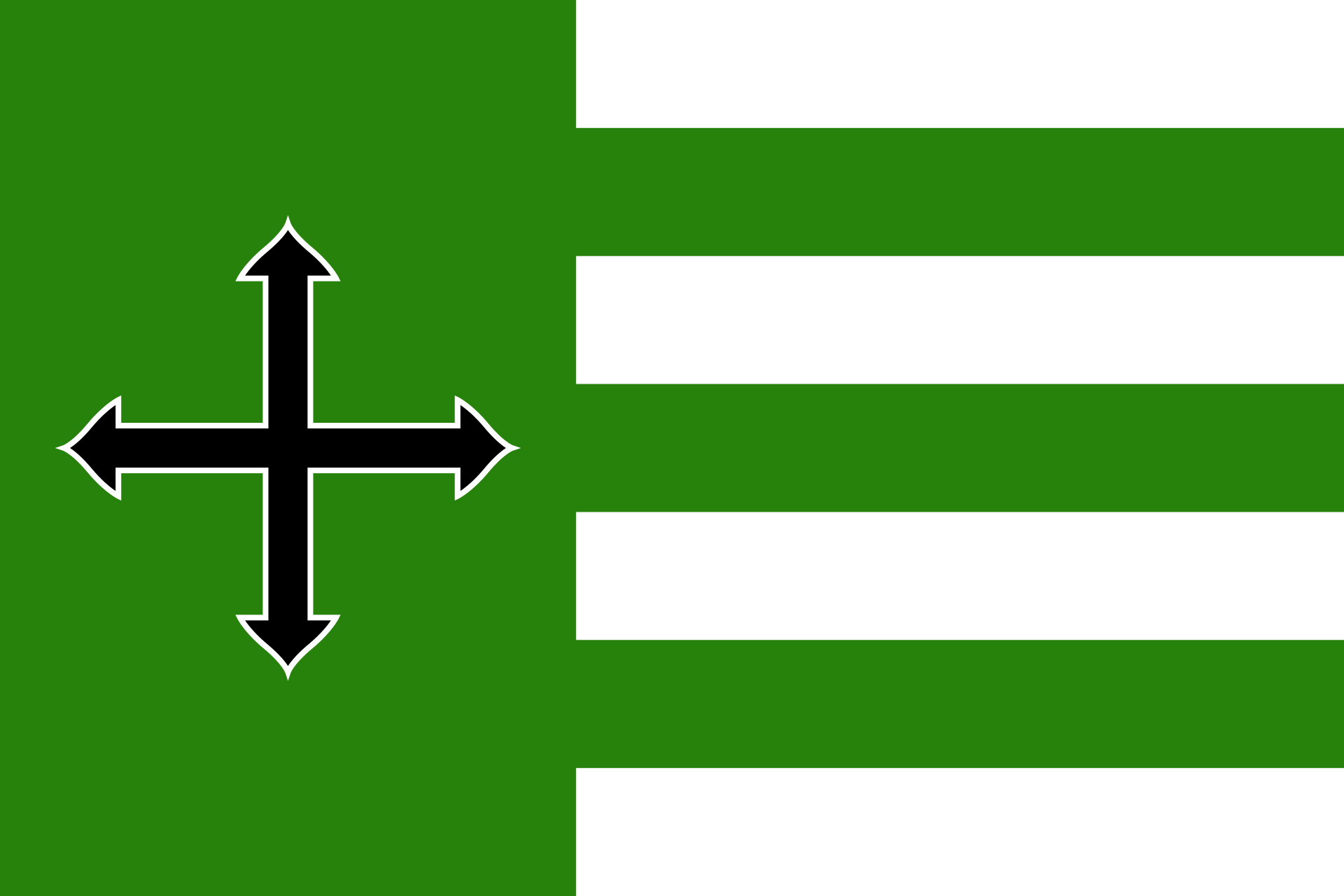
Flag
The flag colors, design and symbolism is taken from the municipal Coat of Arms, with the only exception being that silver is painted white on the flag.
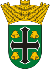
Coat of Arms
The green field of the shield contains a saber cross massed in black, outlined in silver, and has a gold scallop shell in each quadrant formed by the cross. A gold mural crown of three towers crests the shield.
The anthem of Anasco was written by David Cruz Colón. The title is Añasco pueblo querido...
Demographics *
Population
25,596
Land Area: 39.29 sq mi
Density: 676 per sq mi
Median Age: 43.2
Sex: 52% female
Economics **
$10,618
Median household income: $20,167
Puerto Rico: $21,058
Persons below poverty line: 45.5%
Housing, families and educational attainment *
Number of households
8,866
Housing units density:
324.6 (2013)
Persons per household: 2.98
High school grad or higher: 68.3%
Marital status: 43% married
* U.S. Census Bureau 2020 data, unless otherwise noted - Source: Quick Facts Puerto Rico.
** U.S. Census Bureau 2016-2020
Map References
Coordinates: 18.3161° N, 67.1397° W
ZIP Code: 00610, 00611
Driving Distance from San Juan: 97.4 miles
Driving Time: 2 hours, 27 minutes
Did You Know?
The U.S. dollar is the official currency and U.S. citizens don't need a passport.


All content included on this website, is not public domain material. The content is the intellectual property of Magaly Rivera or her content providers. Any duplication or distribution of the information contained herein is prohibited without express written permission.
Designed & Developed by Pencils and Pixels