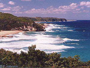
Isabela, Puerto Rico

Isabela is known as "El Jardín del Noroeste" (garden of the northwest) and "El Pueblo de los Quesitos de Hoja".
In 1725 the first European settlers built a town near the Guajataca River and named it San Antonio de la Tuna. The area was later abandoned until the early 1800's when it was resettled. Isabela was founded on May 21, 1819. and named in honor of Isabel Queen of Spain.
Isabela is located in the north-western region of the island, north of San Sebastián; west of Quebradillas; and east of Aguadilla and Moca.
Tourism, industry, dairy products, livestock, leather goods and tobacco are the principal economic activities.
There are many well-known "isabelinos", among them: composer Noel Estrada.
Isabela is made up of 14 barrios (wards/districts):
- Arenales Altos
- Arenales Bajos
- Bajuras
- Bejucos
- Coto
- Galateo Alto
- Galateo Bajo
- Guayabos
- Guerrero
- Jobos
- Llanadas
- Mora
- Planas
- Pueblo
Restaurants
- Eclipse Restaurant & Bar (Puerto Rican), (787) 872-9554
- El Buen Mofongo (Puerto Rican), (787) 830-8496
- Happy Belly's on the Beach (Puerto Rican), (787) 398-9452
- Ocean Front Restaurant (International/Sea Food/Steak), (787) 872-0444
- Punta Saldinera Sea Food (Sea Food), (787) 830-4766
- Restaurante Flavor China (Chinese), (787) 830-8115
Accommodations
- Costa Dorada Beach Resort (Small Inn),
(787) 872-7255
- Fusion Beach Villas (Villa),
(787) 409-8368
- Ocean Front Hotel and Restaurant (Hotel),
(787) 872-0444
- Parador Villas del Mar Hau (Parador),
(787) 872-2045
- Villa Montana Beach Resort (Resort),
1-888-780-9195
(787) 872-9554 - Ocean Blue Villa (Rental),
(787) 546-8038
- Pelican Reef Apartments (Apartment/Condo),
(787) 872-6518
(787) 830-0984
Toll-free 1-866-444-9818 - Villa Bajandas (Rental),
(787) 240-0545
- Villa Tropical (Rental),
(787) 872-7172
Festivals and Events
- Dia de los Santos Inocentes - December
- Fiesta del Gallo Isabelino - February
- Fiesta de Reyes Isabelinos - January 5-6
Every year Isabela celebrates the holiday with a two-day festivity that includes dramatizations of the arrival of the three Magi and their pilgrimage to find the baby Jesus, adore him and present their gifts. The glorious outcome is celebrated with a fiesta at the town square (Plaza Manuel Maria Corchado y Juarbe) that includes a Velorio de Reyes, a traditional song fest in honor of the Magi; handcrafts fair, Trovadores contest with prizes, puppet shows for children, Christmas music and carolers, typical food and drinks. (787) 819-6555 - Fiestas Patronales de San Antonio de Padua - June
Every year, Isabela celebrates a patron saint festival. The festivities include dances, food, parades and religious processions. (787) 872-2100
Education
There are 19 public schools in Isabela, education is handled by the Puerto Rico Department of Education. Isabela is also home of 2 colleges and universities.
Symbols

Anthem: Isabela, permite que me inspire...
Climate
The annual precipitation is around 62.8 inches, and its average temperature is 84.7°F.
10 Day Forecast from weather.com
Demographics *
Population
42,337
Land Area: 55.3 sq mi
Density: 742.8 per sq mi
Median Age: 43.1
Sex: 51% female
Economics **
$9,853
Median household income: $16,996
Puerto Rico: $21,058
Persons below poverty line: 51.2%
Housing, families and educational attainment *
Number of households
15,159
Housing units density:
384.6 (2013)
Persons per household: 2.69
High school grad or higher: 71%
Marital status: 41% married
* U.S. Census Bureau 2020 data, unless otherwise noted - Source: Quick Facts Puerto Rico.
** U.S. Census Bureau 2016-2020
Map References
Coordinates: 18.5131° N, 67.0700° W
ZIP Code: 662
Driving Distance from San Juan: 76.9 miles
Driving Time: 1 hours, 53 minutes
Did You Know?
La Fortaleza in San Juan is the oldest executive mansion in the New World.


All content included on this website, is not public domain material. The content is the intellectual property of Magaly Rivera or her content providers. Any duplication or distribution of the information contained herein is prohibited without express written permission.
Designed & Developed by Pencils and Pixels