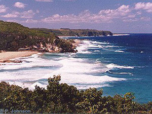
Isabela, Puerto Rico

Isabela is known as "El Jardín del Noroeste" (garden of the northwest) and "El Pueblo de los Quesitos de Hoja".
In 1725 the first European settlers built a town near the Guajataca River and named it San Antonio de la Tuna. The area was later abandoned until the early 1800's when it was resettled. Isabela was founded on May 21, 1819. and named in honor of Isabel Queen of Spain.
Isabela is located in the north-western region of the island, north of San Sebastián; west of Quebradillas; and east of Aguadilla and Moca.
Tourism, industry, dairy products, livestock, leather goods and tobacco are the principal economic activities.
There are many well-known "isabelinos", among them: composer Noel Estrada.
Isabela is made up of 14 barrios (wards/districts):
- Arenales Altos
- Arenales Bajos
- Bajuras
- Bejucos
- Coto
- Galateo Alto
- Galateo Bajo
- Guayabos
- Guerrero
- Jobos
- Llanadas
- Mora
- Planas
- Pueblo
Restaurants
-
[an error occurred while processing this directive]
Accommodations
-
[an error occurred while processing this directive]
Festivals and Events
-
[an error occurred while processing this directive]
Education
There are 19 public schools in Isabela, education is handled by the Puerto Rico Department of Education. Isabela is also home of 2 colleges and universities.
Symbols


Anthem: Isabela, permite que me inspire...
Climate
The annual precipitation is around 62.8 inches, and its average temperature is 84.7°F.
[an error occurred while processing this directive]


